 My GeoNetwork catalogue
INSPIRE - IS GDU NRW DS - Gefährdungspotenziale des Untergrundes in Nordrhein-Westfalen (Bürgerversion) - Datensatz
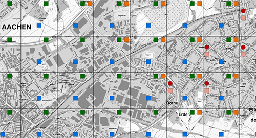
Das Onlineportal "Gefährdungspotenziale des Untergrundes in Nordrhein-Westfalen" (GDU-Bürgerversion) informiert über geologisch oder bergbaulich bedingte Gefährdungspotenziale des Untergrundes in NRW. Aus datenschutzrechtlichen Gründen werden die Informationen nicht grundstücksbezogen, sondern mithilfe von schematisch angeordneten Symbolen, anonymisiert in jeweils 0,5 x 0,5 Kilometer großen Rasterflächen dargestellt. Der Datensatz ist für das INSPIRE-Thema Natural Risk Zones aufbereitet und beinhaltet dementsprechend lediglich die geogen bedingten Gefährdungspotenziale.
INSPIRE
Identification
- File identifier
- 743dc212-c707-44f1-a91d-c2881a26ab54 XML
- Hierarchy level
- Dataset
Online resource
Resource identifier
- Metadata language
- Deutsch
- Spatial representation type
- Vector
Encoding
- Format
-
GML
- Version
-
3.2
- Format
-
GDB
- Version
-
10.X
Projection
- code
- EPSG:4258
Classification of data and services
- Topic category
-
- Geoscientific information
Classification of data and services
Coupled resource
Coupled resource
Classification of data and services
Coupled resource
Coupled resource
Keywords
-
GEMET - INSPIRE themes, version 1.0
-
-
Gebiete mit naturbedingten Risiken
-
-
Spatial scope
-
-
Regional
-
-
High-value dataset categories
-
-
Erdbeobachtung und Umwelt
-
Other keywords
- Discipline
-
-
Geowissenschaften
-
Georisiko
-
GDU
-
Gefährdungspotenziale
-
Karst
-
Erdbebengefährdung
-
Subrosion
-
Erdfall
-
Gasaustritt in Bohrungen
-
- Keywords
-
-
inspireidentifiziert
-
opendata
-
Geographic coverage
))
Temporal reference
Temporal extent
Temporal extent
- Date (Creation)
- 2022-03-08
- Date (Publication)
- 2022-10-27
Quality and validity
- Lineage
-
Teilweise Datenbestandsüberführung des Fachinformationssystems "Gefährdungspotenziale des Untergrundes in Nordrhein-Westfalen" (Bürgerversion) des Geologischen Dienstes NRW in das INSPIRE-Datenmodell Gebiete mit naturbedingten Risiken.
- Distance
- 500 m
Conformity
Conformity
Conformity
Conformity
Conformity
Conformity
Restrictions on access and use
- Access constraints
- Es gelten keine Zugriffsbeschränkungen
- Access constraints
- Dieser Datensatz kann gemäß der Lizenz "Datenlizenz Deutschland Namensnennung 2.0" (https://www.govdata.de/dl-de/by-2-0) genutzt werden.
- Access constraints
-
{ "id": "dl-by-de/2.0", "name": "Datenlizenz Deutschland Namensnennung 2.0", "url": " https://www.govdata.de/dl-de/by-2-0 ", "quelle": "INSP-ISGDU Bürgerversion @ Geologischer Dienst NRW, Jahr des Abrufs" }
Responsible organization (s)
Contact for the resource
- Organisation name
-
Geologischer Dienst NRW
Responsible organization (s)
Contact for the resource
- Organisation name
-
Geologischer Dienst NRW
Metadata information
Contact for the metadata
- Organisation name
-
Geologischer Dienst NRW
- Date stamp
- 2024-08-08
- Metadata language
- Deutsch
- Character set
- 8859 Part 1
SDS
Conformance class 1: invocable
Access Point URL
Endpoint URL
Technical specification
Conformance class 2: interoperable
Access constraints
Limitation
Use constraints
Limitation
Responsible custodian
Contact for the resource
Overviews
Spatial extent
Provided by
