 My GeoNetwork catalogue
Geologische Karte von Bayern 1:500.000 (GK500) - WMS
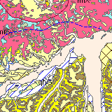
Die "Geologische Karte von Bayern 1:500.000" bietet einen Überblick über die Gesteinsverbreitung in ganz Bayern und den angrenzenden Gebieten (1 km in der Wirklichkeit entspricht 2 mm auf der Karte). Grundlage der GK 500 ist die Topographische Übersichtskarte von Bayern 1:500.000. Zusammen mit dem zugehörigen Erläuterungsbuch ist die GK 500 das Standardwerk zur Geologie Bayerns und liegt mittlerweile in der vierten Auflage aus dem Jahr 1996 vor. Für den WMS-Dienst wurde einige Flächen, Grenzen und Beschriftungen der Originalkarte von 1996 geändert (Stand Februar 2015). Für die GK 500 wurden alle verfügbaren größermaßstäbigen Kartierungen ausgewertet. Dem Charakter einer Übersichtskarte gemäß ist die Darstellung der Gesteinsverbreitung stark generalisiert und die Deckschichten werden weitgehend unterdrückt. Aus diesem Grund ist die GK 500 nur als Grundlage für großräumige Planungen geeignet, die vom geologischen Bau eines Gebiets abhängen. Für die Konzeption lokaler Vorhaben muss auf größermaßstäbige geologische Karten (GK 25, GK 50) oder Spezialuntersuchungen zurückgegriffen werden. Maximale Bildgröße: 4096 x 4096 Pixel.
Simple
Identification info
- Alternate title
-
Geologie
- Date (Revision)
- 2015-02-10T00:00:00.000+01:00
- Status
- On going
- Maintenance and update frequency
- As needed
- Update scope
- Service
-
GEMET - INSPIRE themes, version 1.0
-
-
Geologie
-
-
Service Classification, version 1.0
-
-
infoMapAccessService
-
- Keywords
-
-
gdiby
-
GK500
-
Geologische Kartierung
-
Stratigraphie
-
Bodeninformationssystem Bayern
-
BIS
-
Geologie
-
Geologische Karte
-
sgd_Geologie
-
- Keywords
-
-
inspireidentifiziert
-
- Use limitation
-
keine Einschränkungen
- Use constraints
- Other restrictions
- Other constraints
-
Creative Commons Namensnennung 4.0 International (CC BY 4.0); Datenquelle: Bayerisches Landesamt für Umwelt, www.lfu.bayern.de
- Other constraints
-
{"id":"cc-by/4.0","name":"Creative Commons Namensnennung 4.0 International (CC BY 4.0)","url":" https://creativecommons.org/licenses/by/4.0/deed.de","quelle":"Bayerisches Landesamt für Umwelt, www.lfu.bayern.de"}
- Access constraints
- Other restrictions
- Other constraints
- Es gelten keine Zugriffsbeschränkungen
- Service Type
- view
- Service Version
-
OGC:WMS 1.3.0
- Description
-
Der Dienst umfasst die Landesfläche Bayerns und direkt angrenzender Gebiete.
))
- Coupling Type
- Tight
Contains Operations
- Operation Name
-
GetCapabilities
- Distributed Computing Platforms
- Web services
- Operation Description
-
application/vnd.ogc.wms_xml; text/xml;
Contains Operations
- Operation Name
-
GetMap
- Distributed Computing Platforms
- Web services
- Operation Description
-
image/bmp; image/jpeg; image/tiff; image/png; image/png8; image/png24; image/png32; image/gif; image/svg+xml;
- Connect Point
- https://www.lfu.bayern.de/gdi/wms/geologie/gk500?
Contains Operations
- Operation Name
-
GetFeatureInfo
- Distributed Computing Platforms
- Web services
- Operation Description
-
application/vnd.esri.wms_raw_xml; application/vnd.esri.wms_featureinfo_xml; application/vnd.ogc.wms_xml; text/xml; text/html; text/plain;
- Connect Point
- https://www.lfu.bayern.de/gdi/wms/geologie/gk500?
- Unique resource identifier
- EPSG 4326: WGS 84 / geographisch
- Unique resource identifier
- EPSG 4258: ETRS89 / geographisch
- Unique resource identifier
- EPSG 31467: DHDN / Gauss-Krüger Zone 3
- Unique resource identifier
- EPSG 31468: DHDN / Gauss-Krüger Zone 4
- Unique resource identifier
- EPSG 25832: ETRS89 / UTM Zone 32N
- Unique resource identifier
- EPSG 25833: ETRS89 / UTM Zone 33N
- Unique resource identifier
- EPSG 31258: MGI / Austria GK M31
- Unique resource identifier
- EPSG 3857: WGS 84 / Pseudo-Mercator
- Distribution format
-
-
Sonstiges
()
-
Sonstiges
()
Distributor
- Fees
-
geldleistungsfrei
- OnLine resource
- URL des Dienstes
- OnLine resource
- Informationsseite des LfU
- OnLine resource
-
Dienst "Geologische Karte von Bayern 1:500.000 (GK500) - WMS" (GetCapabilities)
(
OGC Web Map Service
)
application/vnd.ogc.wms_xml; text/xml;
- Hierarchy level
- Service
- Other
-
service
Conformance result
- Date (Publication)
- 2013-04-04
- Explanation
-
see the referenced specification
- Pass
- Yes
Conformance result
- Date (Publication)
- 2009-10-20
- Explanation
-
see the referenced specification
- Pass
- Yes
Conformance result
- Date (Publication)
- 2010-12-07
- Explanation
-
see the referenced specification
- Pass
- No
- File identifier
- 7481af86-055e-3343-968e-557a320d4165 XML
- Metadata language
- Deutsch
- Character set
- UTF8
- Hierarchy level
- Service
- Hierarchy level name
-
service
- Date stamp
- 2026-04-08
- Metadata standard name
-
ISO19119
- Metadata standard version
-
2005/PDAM 1
Overviews
Spatial extent
Provided by
