 My GeoNetwork catalogue
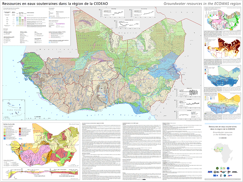
Groundwater resources in the ECOWAS region
The map “Groundwater resources in the ECOWAS region” captures and standardises existing groundwater data of West Africa and gives a consistent regional overview on the groundwater resources. It provides a quantitative assessment of aquifer productivity using a combination of aquifer flow type and expected borehole yield. The map highlights the suitability of aquifers for water supply on different scales while at the same time showing the physical limits of groundwater development. Map elaboration comprised the harmonisation of existing continental and regional geological maps and the attribution of hydrogeological units with expected yield data compiled from a literature meta-survey. Insert maps highlight the geological structure, geogenic background levels of arsenic and fluoride, and groundwater recharge.
Simple
- Alternate title
-
GWR ECOWAS
- Date (Publication)
- 2022-03-01
- Edition
-
v1
- Citation identifier
- 21d99f16-3845-59df-2087-1f24fa5454e0
- Citation identifier
- https://doi.org/10.25928/GWR-ECOWAS.1
- Other citation details
-
BGR, BGS, BRGM, EAWAG & UNESCO (2022): Ressources en eaux souterraines dans la région de la CEDEAO – Groundwater resources in the ECOWAS region. 1 : 5 000 000. DOI: 10.25928/GWR-ECOWAS.1
- Status
- Completed
-
GEMET - INSPIRE themes, version 1.0
-
-
Geologie
-
Geology
-
Géologie
-
-
GEMET - Concepts, version 2.4
-
-
Grundwasser
-
Groundwater
-
Eaux souterraines
-
Hydrogeologie
-
Hydrogeology
-
Hydrogéologie
-
- Place
-
-
Afrika
-
Africa
-
Afrique
-
ECOWAS
-
CEDEAO
-
- Theme
-
-
Aquifer
-
Aquifère
-
Groundwater recharge
-
Recharge des eaux souterraines
-
Geogenic background values
-
Fond géochimique
-
Groundwater resources
-
Ressources en eaux souterraines
-
Groundwater yield
-
Rendement
-
Aquifer media type
-
Type de milieu aquifère
-
Lithology
-
Lithologie
-
Productivity
-
Productivité
-
Sedimentary basins
-
Bassins sédimentaires
-
Fluoride
-
Fluorure
-
Arsenic
-
Opendata
-
Données ouvertes
-
- Access constraints
- Other restrictions
- Other constraints
- Es gelten keine Zugriffsbeschränkungen
- Use constraints
- Other restrictions
- Other constraints
-
Creative Commons Attribution-ShareAlike 4.0 International (CC BY-SA 4.0). Die bereitgestellten Informationen sind wie folgt zu zitieren / The information provided must be quoted as follows / Les informations fournies doivent être citées comme suit: BGR, BGS, BRGM, EAWAG & UNESCO (2022): Ressources en eaux souterraines dans la région de la CEDEAO – Groundwater resources in the ECOWAS region. 1 : 5 000 000. DOI: 10.25928/GWR-ECOWAS.1
- Other constraints
-
{"id": "cc-by-sa/4.0", "name": "Creative Commons Namensnennung - Weitergabe unter gleichen Bedingungen 4.0 International (CC-BY-SA 4.0)", "url": " http://creativecommons.org/licenses/by-sa/4.0/ ", "quelle": "BGR, BGS, BRGM, EAWAG & UNESCO (2022): Ressources en eaux souterraines dans la région de la CEDEAO – Groundwater resources in the ECOWAS region. 1 : 5 000 000. DOI: 10.25928/GWR-ECOWAS.1"}
- Spatial representation type
- Vector
- Denominator
- 5000000
- Language
- fra
- Language
- English
- Character set
- UTF8
- Topic category
-
- Geoscientific information
))
- Unique resource identifier
- EPSG:4326
- Distribution format
-
-
PDF
(
n/a
)
-
Shapefile
(
n/a
)
-
PDF
(
n/a
)
- Transfer size
- 25
- OnLine resource
-
GWR ECOWAS (PDF)
GWR ECOWAS im Format PDF
- Transfer size
- 31
- OnLine resource
-
GWR ECOWAS (Shapefile)
GWR ECOWAS im Format SHP
- OnLine resource
- Karte im BGR-Geoviewer
- OnLine resource
- Website
- Hierarchy level
- Dataset
Conformance result
- Date (Publication)
- 2010-12-08
- Explanation
-
siehe dazu die angegebene Durchführungsbestimmung
- Statement
-
L'élaboration de la carte comprenait l'harmonisation des cartes géologiques continentales et régionales existantes et l'attribution des unités hydrogéologiques avec les données de rendement attendu compilées à partir d'une méta-enquête bibliographique. Map elaboration comprised the harmonisation of existing continental and regional geological maps and the attribution of hydrogeological units with expected yield data compiled from a literature meta-survey.
- File identifier
- 794a6359-fd05-4851-8790-9281d1c7717b XML
- Metadata language
- fra
- Character set
- UTF8
- Hierarchy level
- Dataset
- Hierarchy level name
-
Grundwasser
- Date stamp
- 2025-03-12
- Metadata standard name
-
INSPIRE Metadata Implementing Rules: Technical Guidelines based on EN ISO 19115 and EN ISO 19119
- Metadata standard version
-
n/a
Overviews
Spatial extent
Provided by
