 My GeoNetwork catalogue
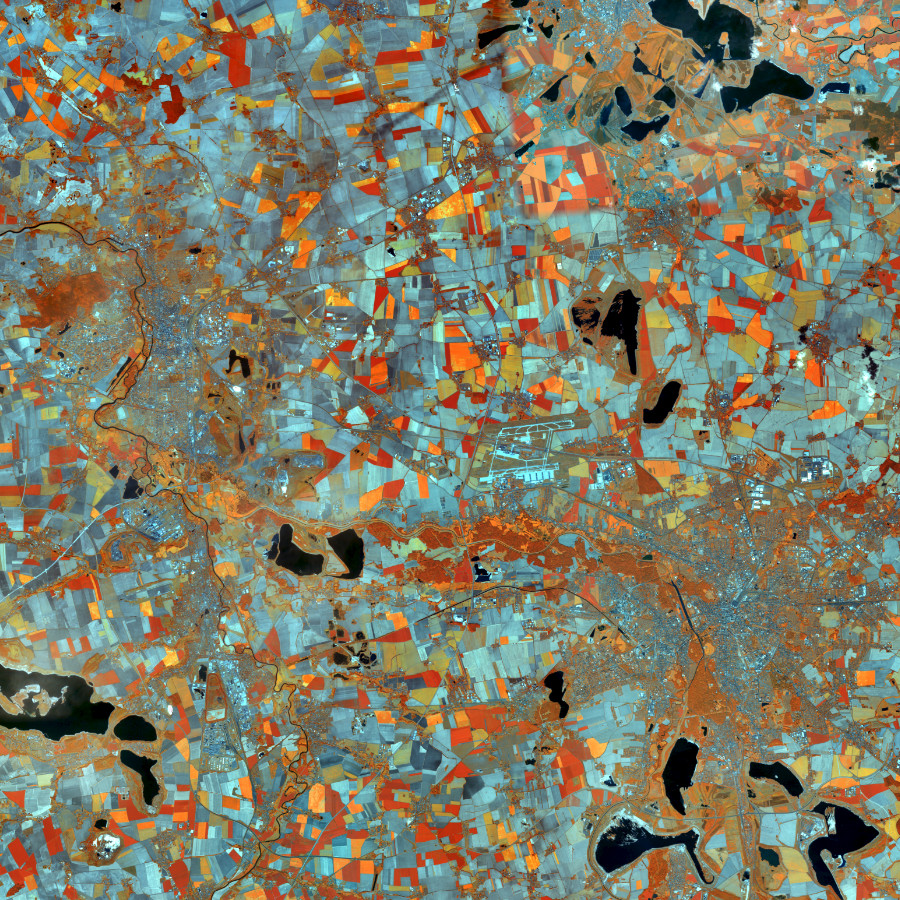
WMS RapidEye 2012
Darstellungsdienst für RapidEye Satellitenbilder Deutschland, Echt- und Falschfarbendarstellung Stand 2012 im Gebiet der Bundesrepublik Deutschland.
Das BKG stellt multitemporale Satellitenbilder des Sensors RapidEye (5 Kanäle,: R, G, B, RE, IR) aus den Jahren 2009/2010 und 2012 zur Verfügung.Die Bilder sind aus einer Höhe von ca. 630 km aufgenommen und haben eine Bodenauflösung von 5 m. Der Bewölkungsanteil beträgt weniger als 5 %.
Der Dienst wird ausschließlich Bundesbehörden zur Verfügung gestellt.
- Identification
- Distribution
- Quality
- Spatial rep.
- Ref. system
- Content
- Portrayal
- Metadata
- Md. constraints
- Md. maintenance
- Schema info
Identification
Identification info
Service Identification (19119)
Citation
- Alternate title
-
wms_rapideye_2012
- Date (Creation)
- 2014-12-12T00:00:00.000+01:00
- Status
- Completed
+49 69 6333-251
https://www.bkg.bund.de
+49 69 6333-235
https://www.bkg.bund.de
Maintenance information
- Maintenance and update frequency
- Not planned
- Update scope
- Service
-
Service Classification, version 1.0
-
-
infoMapAccessService
-
- Keywords
-
-
RapidEye
-
ViewService
-
WMS
-
infoMapAccessService
-
Bund
-
BKG
-
Bundesamt für Kartographie und Geodäsie
-
Deutschland
-
Hintergrundkarte
-
Legal constraints
- Use constraints
- Other restrictions
- Other constraints
-
Quellenvermerk: Includes material © (Jahr) Planet Labs Netherlands BV. All rights reserved.
Legal constraints
- Access constraints
- Other restrictions
- Other constraints
-
Es gelten Zugriffsbeschränkungen. Für den Erwerb von Nutzungsrechten wenden Sie sich deshalb bitte an die Zentrale Stelle Geotopographie der AdV (ZSGT) / Dienstleistungszentrum (DLZ) des Bundesamtes für Kartographie und Geodäsie: https://www.bkg.bund.de/DE/Service/Kontakt/kontakt.html .
- Service Type
- view
- Service Version
-
OGC:WMS 1.3.0
- Service Version
-
OGC:WMS 1.1.1
Extent
Geographic description
- Extent type code
- Yes
- Geographic identifier
- Raumbezug von: RapidEye 2012
))
Geographic description
- Extent type code
- Yes
- Geographic identifier
- Bundesrepublik Deutschland
))
- Coupling Type
- Tight
Contains Operations
- Operation Name
-
GetCapabilities
- Distributed Computing Platforms
- Web services
- Connect Point
- https://sg.geodatenzentrum.de/wms_rapideye_2012?
Contains Operations
- Operation Name
-
GetMap
- Distributed Computing Platforms
- Web services
- Connect Point
- https://sg.geodatenzentrum.de/wms_rapideye_2012?
Contains Operations
- Operation Name
-
GetFeatureInfo
- Distributed Computing Platforms
- Web services
- Connect Point
- https://sg.geodatenzentrum.de/wms_rapideye_2012?
- Operates On
Distribution
Distribution
- Distribution format
-
-
TIFF
()
-
PNG
()
-
JPEG
()
-
TIFF
()
- OnLine resource
- GetCapabilites
- OnLine resource
- Geodatenzentrum
- OnLine resource
- Dokumentation
- OnLine resource
- Dienst "WMS RapidEye 2012" (GetCapabilities) ( OGC Web Map Service )
Quality
Data quality
Scope
- Hierarchy level
- Service
- Other
-
service
Conformance result
Citation
- Date (Publication)
- 2020-01-20
- Explanation
-
see the referenced specification
- Pass
- Yes
Ref. system
- Unique resource identifier
- EPSG 4326: WGS 84 / geographisch
- Reference system identifier
- CRS 84: CRS 84 / mathematisch
- Unique resource identifier
- EPSG 25832: ETRS89 / UTM Zone 32N
- Unique resource identifier
- EPSG 25833: ETRS89 / UTM Zone 33N
- Unique resource identifier
- EPSG 31466: DHDN / Gauss-Krüger Zone 2
- Unique resource identifier
- EPSG 31467: DHDN / Gauss-Krüger Zone 3
- Unique resource identifier
- EPSG 31468: DHDN / Gauss-Krüger Zone 4
- Unique resource identifier
- EPSG 31469: DHDN / Gauss-Krüger Zone 5
- Unique resource identifier
- EPSG 5676: DHDN / Gauss-Krüger Zone 2 (E-N)
- Unique resource identifier
- EPSG 5677: DHDN / Gauss-Krüger Zone 3 (E-N)
- Unique resource identifier
- EPSG 5678: DHDN / Gauss-Krüger Zone 4 (E-N)
- Unique resource identifier
- EPSG 5679: DHDN / Gauss-Krüger Zone 5 (E-N)
- Unique resource identifier
- EPSG 3857: WGS 84 / Pseudo-Mercator
- Unique resource identifier
- EPSG 4258: ETRS89 / geographisch
- Unique resource identifier
- EPSG 3034: ETRS89 / LCC Europa
- Unique resource identifier
- EPSG 3035: ETRS89 / LAEA Europa
- Unique resource identifier
- EPSG 3044: ETRS89 / UTM Zone 32N (N-E)
- Unique resource identifier
- EPSG 3045: ETRS89 / UTM Zone 33N (N-E)
- Unique resource identifier
- EPSG 4839: ETRS89 / LCC Deutschland (N-E)
- Unique resource identifier
- EPSG 4647: ETRS89 / UTM Zone 32N (zE-N)
- Unique resource identifier
- EPSG 5650: ETRS89 / UTM Zone 33N (zE-N)
Metadata
Metadata
- File identifier
- 7B620DAE-5D3C-41F8-B9F9-970E58F9F377 XML
- Metadata language
- Deutsch
- Character set
- UTF8
- Hierarchy level
- Service
- Hierarchy level name
-
service
- Date stamp
- 2026-05-05
- Metadata standard name
-
ISO19119
- Metadata standard version
-
2005/PDAM 1
Overviews
Spatial extent
Provided by
