 My GeoNetwork catalogue
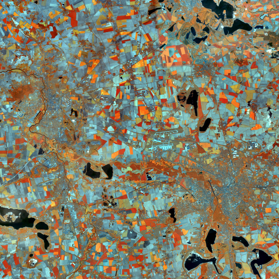
WMS RapidEye 2012
Darstellungsdienst für RapidEye Satellitenbilder Deutschland, Echt- und Falschfarbendarstellung Stand 2012 im Gebiet der Bundesrepublik Deutschland.
Das BKG stellt multitemporale Satellitenbilder des Sensors RapidEye (5 Kanäle,: R, G, B, RE, IR) aus den Jahren 2009/2010 und 2012 zur Verfügung.Die Bilder sind aus einer Höhe von ca. 630 km aufgenommen und haben eine Bodenauflösung von 5 m. Der Bewölkungsanteil beträgt weniger als 5 %.
Der Dienst wird ausschließlich Bundesbehörden zur Verfügung gestellt.
INSPIRE
Identification
- File identifier
- 7B620DAE-5D3C-41F8-B9F9-970E58F9F377 XML
- Hierarchy level
- Service
Online resource
- Protocol
- OGC Web Map Service
Resource identifier
Encoding
- Format
-
TIFF
- Format
-
PNG
- Format
-
JPEG
Projection
- code
-
CRS 84: CRS 84 / mathematisch
Classification of data and services
- Service Type
- view
- Coupling Type
- Tight
Coupled resource
Coupled resource
Classification of data and services
- Service Type
- view
- Coupling Type
- Tight
Coupled resource
Coupled resource
Keywords
-
Service Classification, version 1.0
-
-
infoMapAccessService
-
Other keywords
- Keywords
-
-
RapidEye
-
ViewService
-
WMS
-
infoMapAccessService
-
Bund
-
BKG
-
Bundesamt für Kartographie und Geodäsie
-
Deutschland
-
Hintergrundkarte
-
Geographic coverage
))
))
Temporal reference
Temporal extent
Temporal extent
- Date (Creation)
- 2014-12-12T00:00:00.000+01:00
Conformity
Conformity
Conformity
Conformity
Conformity
Conformity
- Explanation
-
see the referenced specification
Restrictions on access and use
- Access constraints
-
Quellenvermerk: Includes material © (Jahr) Planet Labs Netherlands BV. All rights reserved.
- Access constraints
-
Es gelten Zugriffsbeschränkungen. Für den Erwerb von Nutzungsrechten wenden Sie sich deshalb bitte an die Zentrale Stelle Geotopographie der AdV (ZSGT) / Dienstleistungszentrum (DLZ) des Bundesamtes für Kartographie und Geodäsie: https://www.bkg.bund.de/DE/Service/Kontakt/kontakt.html .
Responsible organization (s)
Contact for the resource
- Organisation name
-
Bundesamt für Kartographie und Geodäsie (BKG)
- Organisation name
-
Bundesamt für Kartographie und Geodäsie (BKG)
Responsible organization (s)
Contact for the resource
- Organisation name
-
Bundesamt für Kartographie und Geodäsie (BKG)
- Organisation name
-
Bundesamt für Kartographie und Geodäsie (BKG)
Metadata information
Contact for the metadata
- Organisation name
-
Bundesamt für Kartographie und Geodäsie (BKG)
- Date stamp
- 2026-05-05
- Metadata language
- Deutsch
SDS
Conformance class 1: invocable
- Pass
- Yes
Access Point URL
Endpoint URL
Technical specification
- Date
- Explanation
-
see the referenced specification
Conformance class 2: interoperable
Access constraints
Limitation
- string
-
Es gelten Zugriffsbeschränkungen. Für den Erwerb von Nutzungsrechten wenden Sie sich deshalb bitte an die Zentrale Stelle Geotopographie der AdV (ZSGT) / Dienstleistungszentrum (DLZ) des Bundesamtes für Kartographie und Geodäsie: https://www.bkg.bund.de/DE/Service/Kontakt/kontakt.html .
Use constraints
- Use constraints
- Other restrictions
- Other constraints
-
Quellenvermerk: Includes material © (Jahr) Planet Labs Netherlands BV. All rights reserved.
Limitation
- string
-
Quellenvermerk: Includes material © (Jahr) Planet Labs Netherlands BV. All rights reserved.
Responsible custodian
Contact for the resource
Conformance class 3: harmonized
Contains Operations
- Operation Name
-
GetCapabilities
- Distributed Computing Platforms
- Web services
- Connect Point
- https://sg.geodatenzentrum.de/wms_rapideye_2012?
Contains Operations
- Operation Name
-
GetMap
- Distributed Computing Platforms
- Web services
- Connect Point
- https://sg.geodatenzentrum.de/wms_rapideye_2012?
Contains Operations
- Operation Name
-
GetFeatureInfo
- Distributed Computing Platforms
- Web services
- Connect Point
- https://sg.geodatenzentrum.de/wms_rapideye_2012?
Overviews
Spatial extent
Provided by
