 My GeoNetwork catalogue
Map of Mineral Resources of Germany 1:1,000,000
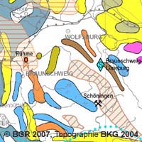
The Map of Mineral Resources of Germany 1: 1,000,000 (BSK1000) provides the basic information on the spatial distribution of energy resources and mineral raw materials (‘stones and earth’, industrial minerals and ores) in Germany. The mineral resources are summarized in commodity groups, represented as different colored units. The back of the map contains information about the definition, creation, important deposits, use and economic significance of all the raw materials shown. The map is published by the Federal Institute for Geosciences and Natural Resources in cooperation with the National Geological Surveys.
Simple
- Alternate title
-
BSK1000
- Date (Publication)
- 2007-09-30
- Edition
-
1. Auflage
- Citation identifier
- 7CE98053-1E22-467B-8E72-F83FCB4F6B50
- Other citation details
-
Größe der gedruckten Karte: 82.0 cm x 96.0 cm - Size of printed map: 82.0 cm x 96.0 cm
- Status
- Completed
-
GEMET - INSPIRE themes, version 1.0
-
-
Geologie
-
Geology
-
- Theme
-
-
inspireidentifiziert
-
mineral resources
-
Rohstoff
-
Rohstoffgeologie
-
Rohstoffverbreitung
-
opendata
-
- Place
-
-
Deutschland
-
-
Spatial scope
-
-
National
-
-
High-value dataset categories
-
-
Erdbeobachtung und Umwelt
-
- Access constraints
- Other restrictions
- Other constraints
- Es gelten keine Zugriffsbeschränkungen
- Use constraints
- Other restrictions
- Other constraints
-
Allgemeine Geschäftsbedingungen, s. https://www.bgr.bund.de/agb - General Terms and Conditions, s. https://www.bgr.bund.de/agb_en
- Other constraints
-
Dieser Datensatz kann gemäß der "Nutzungsbestimmungen für die Bereitstellung von Geodaten des Bundes" ( https://sg.geodatenzentrum.de/web_public/gdz/lizenz/geonutzv.pdf ) genutzt werden.
- Other constraints
-
Preis der gedruckten Karte: 13,55 EUR (zzgl. 7% MWSt. und Versandkosten) Weitere Informationen zur Bestellung beim Internationalen Landkartenhaus siehe https://www.bgr.bund.de/produktcenter-bestellhinweis-ILH
- Other constraints
-
{"id": "geoNutz/20130319", "name": "Nutzungsbestimmungen für die Bereitstellung von Geodaten des Bundes", "url": " https://sg.geodatenzentrum.de/web_public/gdz/lizenz/geonutzv.pdf ", "quelle": "Bundesanstalt für Geowissenschaften und Rohstoffe (BGR)"}
- Spatial representation type
- Grid
- Spatial representation type
- Vector
- Denominator
- 1000000
- Language
- Deutsch
- Character set
- UTF8
- Topic category
-
- Geoscientific information
- Economy
))
- Geographic identifier
- Regionalschlüssel / 000000000000
- Unique resource identifier
- EPSG:4326
- Distribution format
-
-
PDF
(
n/a
)
-
Shapefile
(
n/a
)
-
JPEG
(
n/a
)
-
TIFF
(
n/a
)
-
gedruckt
(
n/a
)
-
georef. TIFF
(
n/a
)
-
PDF
(
n/a
)
- Transfer size
- 6
- OnLine resource
-
BSK1000 (PDF)
BSK1000 im Format Adobe Acrobat Datei (Auflösung 300 dpi)
- Transfer size
- 2
- OnLine resource
-
BSK1000 (Shapefile)
BSK1000 im Format ESRI Shape
- Transfer size
- 10
- OnLine resource
-
BSK1000 (JPEG)
BSK1000 im Format JPEG (Auflösung 150 dpi)
- Transfer size
- 139
- OnLine resource
-
BSK1000 (TIFF)
BSK1000 im Format TIFF (Auflösung 300 dpi)
- OnLine resource
-
BSK1000 (gedruckt)
BSK1000 im Format gedruckt, gefalzt
- Transfer size
- 24
- OnLine resource
-
BSK1000 (georef. TIFF)
BSK1000 im Format georeferenziertes TIFF
- OnLine resource
- BSK1000-Internetseite - BSK1000-Website
- OnLine resource
- Karte im BGR-Geoviewer
- Hierarchy level
- Dataset
Conformance result
- Date (Publication)
- 2010-12-08
- Explanation
-
siehe dazu die angegebene Durchführungsbestimmung
- Statement
-
Kartographische Redaktion und Herstellung: C. Vinnemann
- File identifier
- 7F12ED28-84DA-4AAE-AEDB-33310962705E XML
- Metadata language
- Deutsch
- Character set
- UTF8
- Hierarchy level
- Dataset
- Hierarchy level name
-
Geologie
- Hierarchy level name
-
Rohstoffe
- Date stamp
- 2026-01-13
- Metadata standard name
-
INSPIRE Metadata Implementing Rules: Technical Guidelines based on EN ISO 19115 and EN ISO 19119
- Metadata standard version
-
n/a
Overviews
Spatial extent
Provided by
