 My GeoNetwork catalogue
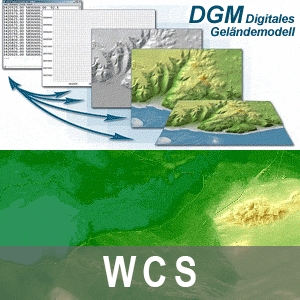
WCS Digitales Geländemodell Gitterweite 1m Brandenburg mit Berlin
Dieser Web Coverage Service stellt das Digitale Geländemodell mit der Bodenauflösung von 1m als farbige Höhenschichten mit Schummerung vom Gebiet Brandenburg mit Berlin zur Verfügung.
Simple
Identification info
- Alternate title
-
Digitale Geländemodelle
- Date (Publication)
- 2015-04-10T00:00:00
- Citation identifier
- https://registry.gdi-de.org/id/de.bb.metadata/7cbcb2a6-bd70-45cb-b34b-6d225f93e012
+49 331 8844-16123
- Maintenance and update frequency
- Irregular
- Keywords
-
-
opendata
-
- Theme
-
-
3D
-
BB-BE
-
WCS
-
AdVMIS
-
WCS_BB-BE_DGM_1m
-
Höhenlinien
-
Relief
-
infoCoverageAccessService
-
- Place
-
-
Brandenburg
-
Berlin
-
-
BE/BB Schlagwortliste, Version 1.0
-
-
Photogrammetrie
-
Vermessung
-
Geländemodell
-
- Use constraints
- Other restrictions
- Other constraints
-
Die Daten können gemäß der „Datenlizenz Deutschland - Namensnennung - Version 2.0“ ( https://www.govdata.de/dl-de/by-2-0 ) genutzt werden. Namensnennung: "GeoBasis-DE/LGB“, Beispiel: „© GeoBasis-DE/LGB, dl-de/by-2-0, (Daten geändert)“, (Klammer = optional) Hinweis: werden auch Daten des Bundeslandes Berlin genutzt, ist der Copyright-Vermerk um den Hinweis “© Geoportal Berlin, dl-de/zero-2-0“ zu ergänzen. Beispiel: „© GeoBasis-DE/LGB, dl-de/by-2-0; © Geoportal Berlin, dl-de/zero-2-0 (Daten geändert)“, (Klammer = optional)
- Other constraints
-
{"id":"dl-by-de/2.0","name":"Datenlizenz Deutschland - Namensnennung - Version 2.0","url":" https://www.govdata.de/dl-de/by-2-0","quelle":"Quelle : © GeoBasis-DE/LGB, dl-de/by-2-0; © Geoportal Berlin, dl-de/zero-2-0"}
- Access constraints
- Other restrictions
- Other constraints
- Es gelten keine Zugriffsbeschränkungen
- Service Type
- download
- Service Version
-
OGC:WCS 2.0.1
- Description
-
Land Brandenburg
))
- Coupling Type
- Tight
Contains Operations
- Operation Name
-
GetCapabilities
- Distributed Computing Platforms
- Web services
- Connect Point
- https://isk.geobasis-bb.de/ows/dgm_wcs?
Contains Operations
- Operation Name
-
GetCoverage
- Distributed Computing Platforms
- Web services
- Connect Point
- https://isk.geobasis-bb.de/ows/dgm_wcs?
Contains Operations
- Operation Name
-
DescribeCoverage
- Distributed Computing Platforms
- Web services
- Connect Point
- https://isk.geobasis-bb.de/ows/dgm_wcs?
- Unique resource identifier
- EPSG:25832
- Unique resource identifier
- EPSG:25833
- Unique resource identifier
- EPSG:3034
- Unique resource identifier
- EPSG:3035
- Unique resource identifier
- EPSG:3044
- Unique resource identifier
- EPSG:3045
- Unique resource identifier
- EPSG:3857
- Unique resource identifier
- EPSG:4258
- Unique resource identifier
- EPSG:4326
- Unique resource identifier
- EPSG:4647
- Unique resource identifier
- EPSG:4839
- Unique resource identifier
- EPSG:5650
Distributor
+49 331 8844-16123
- Fees
-
kostenfrei, unter Beachtung der Lizenzbedingungen
- OnLine resource
- Produktinformation ( Web Address (URL) )
- OnLine resource
- Hilfe zur Nutzung von Downloaddiensten ( File for download )
- File identifier
- 7cbcb2a6-bd70-45cb-b34b-6d225f93e012 XML
- Metadata language
- Deutsch
- Character set
- UTF8
- Hierarchy level
- Service
- Hierarchy level name
-
service
- Date stamp
- 2025-07-18T14:53:29
- Metadata standard name
-
ISO 19115:2003/Cor 1:2006, 19119:2005/Amd 1:2008 (AdV-Metadatenprofil)
- Metadata standard version
-
1.2.1
+49 331 8844-16123
Overviews
Spatial extent
Provided by
