 My GeoNetwork catalogue
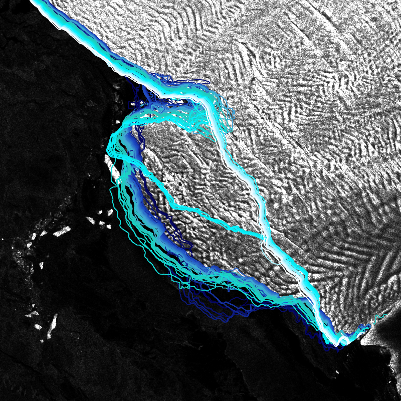
IceLines - Sentinel-1 - Antarctica
IceLines (Ice Shelf and Glacier Front Time Series) is an automated calving front monitoring service providing monthly ice shelf front time series of major Antarctic ice shelves. The provided time series allows to discover the dynamics of ice shelf front changes and calving events. The front positions are automatically derived from Sentinel-1 data based on a deep neuronal network called HED-U-Net. The time series covers the timespan 2014 to today (partly limited due to Sentinel-1 data availability). Incorrectly extracted fronts are truncated which might lead to gaps in the time series especially between December to March due to strong surface melt. Annual averages are calculated based on the extracted monthly fronts (excluding the summer months) and provide more robust results due to temporal aggregation
INSPIRE
Identification
- File identifier
- 7ffa8888-fe28-4f12-b3a1-d08eae6f265e XML
- Hierarchy level
- Series
Online resource
- Protocol
-
OGC:WMS
- Protocol
-
OGC:WMS
- Protocol
-
OGC:WMS
- Protocol
-
OGC:WMS
- Protocol
-
OGC:WMS
- Protocol
-
OGC:WMS-http-get-capabilities
- Protocol
-
WWW:LINK-1.0-http--link
- Protocol
-
WWW:LINK-1.0-http--link
- Protocol
-
WWW:LINK-1.0-http--link
- Protocol
-
WWW:LINK-1.0-http--link
Resource identifier
- Metadata language
- English
- Spatial representation type
- Vector
Encoding
- Format
-
GeoPackage
Projection
- code
- EPSG:3031
Classification of data and services
- Topic category
-
- Environment
Classification of data and services
Coupled resource
Coupled resource
Classification of data and services
Coupled resource
Coupled resource
Keywords
-
GEMET - INSPIRE themes, version 1.0
-
-
Land cover
-
Other keywords
- Keywords
-
-
opendata
-
IceLines
-
Antarctica
-
Landcover
-
Sentinel-1
-
time-series
-
yearly
-
monthly
-
quarterly
-
daily
-
inspireidentifiziert
-
- Place
Geographic coverage
))
Temporal reference
Temporal extent
- Begin
- 2014-12-01
Temporal extent
- Date (Creation)
- 2022-06-01T00:00:00
Quality and validity
- Lineage
-
Created from Sentinel-1 Copernicus data provided by the Alaska Satellite Facility (ASF) https://vertex.daac.asf.alaska.edu/ and the European Space Agency (ESA) https://scihub.copernicus.eu/ .
Processing steps include the pre-processing of Sentinel-1 dual and single polarized GRD scenes with the ESA SNAP toolbox. The fronts are extracted with a deep learning approach described in:
Heidler, K., Mou, L., Baumhoer, C., Dietz, A., and Zhu, X. X.: HED-UNet: Combined Segmentation and Edge Detection for Monitoring the Antarctic Coastline, IEEE Trans. Geosci. Remote Sensing, 1–14, https://doi.org/10.1109/TGRS.2021.3064606 , 2021.
Baumhoer, C. A., Dietz, A. J., Kneisel, C., and Kuenzer, C.: Automated Extraction of Antarctic Glacier and Ice Shelf Fronts from Sentinel-1 Imagery Using Deep Learning, Remote Sensing, 11, 2529, https://doi.org/10.3390/rs11212529 , 2019.
- Denominator
- 80000
Conformity
Conformity
Conformity
Conformity
Conformity
Conformity
- Explanation
-
See the referenced specification
Restrictions on access and use
- Access constraints
- There are no limitations on public access to spatial data sets and services.
- Access constraints
-
Nutzungsbedingungen: Lizenz, https://creativecommons.org/licenses/by/4.0 / terms of use: https://creativecommons.org/licenses/by/4.0/
- Access constraints
-
{"id": "cc-by/4.0",
"name": "Creative Commons Namensnennung – 4.0 International (CC BY 4.0)",
"url": " http://dcat-ap.de/def/licenses/cc-by/4.0 ",
"quelle": "Copyright DLR (year of production)"}
Responsible organization (s)
Contact for the resource
- Organisation name
-
German Aerospace Center (DLR)
Responsible organization (s)
Contact for the resource
- Organisation name
-
German Aerospace Center (DLR)
Metadata information
Contact for the metadata
- Organisation name
-
German Aerospace Center (DLR)
- Date stamp
- 2024-06-20T13:07:35
- Metadata language
- English
- Character set
- UTF8
SDS
Conformance class 1: invocable
Access Point URL
Endpoint URL
Technical specification
Conformance class 2: interoperable
Access constraints
Limitation
Use constraints
Limitation
Responsible custodian
Contact for the resource
Overviews

Spatial extent
Provided by
