 My GeoNetwork catalogue
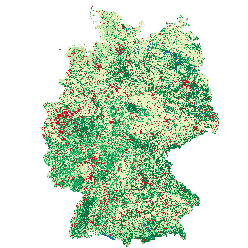
Land Cover DE - Sentinel-2 - Germany, 2015
This land cover classification of Germany was created using Sentinel-2 imagery from the years 2015 to 2017 and LUCAS 2015 in-situ reference data ( https://ec.europa.eu/eurostat/web/lucas ). It contains seven land cover types: (1) artificial land, (2) open soil, (3) high seasonal vegetation, (4) high perennial vegetation, (5) low seasonal vegetation, (6) low perennial vegetation and (7) water with a spatial resolution of 10m x 10m. For further information, please see the following publication: https://doi.org/10.1016/j.jag.2020.10206 5
- Identification
- Distribution
- Quality
- Spatial rep.
- Ref. system
- Content
- Portrayal
- Metadata
- Md. constraints
- Md. maintenance
- Schema info
Identification
Data identification
Citation
- Date (Creation)
- 2020-02-05T12:48:00
- Edition
-
1.0
- Citation identifier
- https://geoservice.dlr.de/catalogue/srv/metadata/8205e1c9-14c3-47a7-ac12-8c890225680a
- Presentation form
- Digital map
- Other citation details
-
DOI: 10.15489/1ccmlap3mn39
- Status
- Completed
- Maintenance and update frequency
- As needed
-
GEMET - INSPIRE themes, version 1.0
-
-
Land cover
-
- Keywords
-
-
Sentinel-2
-
Land cover map
-
Germany
-
- Use limitation
-
Nutzungseinschränkungen: Das DLR ist nicht haftbar für Schäden, die sich aus der Nutzung ergeben. / Use Limitations: DLR not liable for damage resulting from use.
- Use limitation
-
Nutzungsbedingungen: Lizenz, https://creativecommons.org/licenses/by-nc/4.0 / Terms of use: License, https://creativecommons.org/licenses/by-nc/4.0
Legal constraints
- Access constraints
- Other restrictions
- Other constraints
-
License
Legal constraints
- Use constraints
- License
- Use constraints
- Other restrictions
- Other constraints
-
Nutzungsbedingungen: Lizenz, https://creativecommons.org/licenses/by-nc/4.0 / Terms of use: License, https://creativecommons.org/licenses/by-nc/4.0
- Other constraints
-
{"id": "cc-by-nc/4.0",
"name": "Creative Commons Namensnennung - Nicht kommerziell 4.0 International (CC BY-NC 4.0)",
"url": " http://dcat-ap.de/def/licenses/cc-by-nc/4.0 ",
"quelle": "Copyright DLR (year of production)"}
- Spatial representation type
- Grid
- Denominator
- 20000
- Language
- English
- Character set
- UTF8
- Topic category
-
- Imagery base maps earth cover
Extent
))
- Begin date
- 2015-06-27T10:25:31
- End date
- 2017-09-29T10:20:07
Distribution
Distribution
- Distribution format
-
Digital transfer options
- OnLine resource
-
LCC_DE_2015
(
OGC:WMS
)
Land Cover DE, 2015
- OnLine resource
-
EOC Geoservice Map Context
(
WWW:LINK-1.0-http--link
)
EOC Geoservice Map Context (de:lcc)
- OnLine resource
-
HTTP Download
(
WWW:LINK-1.0-http--link
)
HTTP Download (Land Cover DE)
- OnLine resource
-
Scientific publication
(
WWW:LINK-1.0-http--link
)
Scientific publication describing the Land Cover DE product
Quality
Data quality
- Hierarchy level
- Dataset
Domain consistency
- Measure identification
- INSPIRE / Conformity_001
Conformance result
Citation
- Date (Publication)
- 2010-12-08
- Explanation
-
See the referenced specification.
- Pass
- Yes
Lineage
- Statement
-
Input data: Sentinel-2 multispectral imagery, LUCAS in-situ reference points, and imperviousness layers from OSM and the LoD1-de building model.
- Description
-
This dataset was created using a median mosaic of all collected Sentinel-2 Scenes up until April 30, 2017 with a cloud cover of less than 60 percent. From these a total of 226 spectral and textural image features were derived. Additionally imperviousness from buildings, roads and railways were included. A supervised machine learning classifier was trained with in-situ reference points from the 2015 Land Use and Coverage Area Frame Survey (LUCAS). For further details we refer to the following publication: Weigand, M., Staab, J., Wurm, M., Taubenböck, H. (2020): Spatial and semantic effects of LUCAS samples on fully automated land use/land cover classification in high-resolution Sentinel-2 data, International Journal of Applied Earth Observation and Geoinformation, Volume 88, 102065, ISSN 0303-2434. https://doi.org/10.1016/j.jag.2020.10206 5
Spatial rep.
Grid spatial representation
- Number of dimensions
- 2
Dimension
- Dimension name
- Column
- Dimension size
- 74592
- Resolution
- 10 m
Dimension
- Dimension name
- Row
- Dimension size
- 90211
- Resolution
- 10 m
- Cell geometry
- Area
- Transformation parameter availability
- No
Ref. system
- Reference system identifier
- EPSG / ETRS89 / LAEA Europe (EPSG:3035) / 8.6
Metadata
Metadata
- File identifier
- 8205e1c9-14c3-47a7-ac12-8c890225680a XML
- Metadata language
- English
- Character set
- UTF8
- Hierarchy level
- Dataset
- Hierarchy level name
-
Dataset
- Date stamp
- 2024-11-11T08:38:09
- Metadata standard name
-
19115-1:2014/19139
- Metadata standard version
-
1.0
Overviews
Spatial extent
Provided by
