 My GeoNetwork catalogue
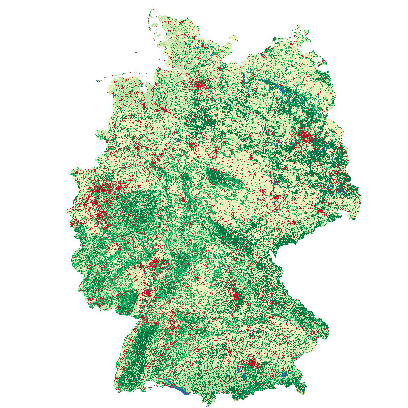
Land Cover DE - Sentinel-2 - Germany, 2015
This land cover classification of Germany was created using Sentinel-2 imagery from the years 2015 to 2017 and LUCAS 2015 in-situ reference data ( https://ec.europa.eu/eurostat/web/lucas ). It contains seven land cover types: (1) artificial land, (2) open soil, (3) high seasonal vegetation, (4) high perennial vegetation, (5) low seasonal vegetation, (6) low perennial vegetation and (7) water with a spatial resolution of 10m x 10m. For further information, please see the following publication: https://doi.org/10.1016/j.jag.2020.10206 5
INSPIRE
Identification
- File identifier
- 8205e1c9-14c3-47a7-ac12-8c890225680a XML
- Hierarchy level
- Dataset
Online resource
- Protocol
-
OGC:WMS
- Protocol
-
WWW:LINK-1.0-http--link
- Protocol
-
WWW:LINK-1.0-http--link
- Protocol
-
WWW:LINK-1.0-http--link
Resource identifier
- Metadata language
- English
- Spatial representation type
- Grid
Encoding
Projection
- code
-
ETRS89 / LAEA Europe (EPSG:3035)
Classification of data and services
- Topic category
-
- Imagery base maps earth cover
Classification of data and services
Coupled resource
Coupled resource
Classification of data and services
Coupled resource
Coupled resource
Keywords
-
GEMET - INSPIRE themes, version 1.0
-
-
Land cover
-
Other keywords
- Keywords
-
-
Sentinel-2
-
Land cover map
-
Germany
-
Geographic coverage
))
Temporal reference
Temporal extent
- Begin
- 2015-06-27T10:25:31
- End
- 2017-09-29T10:20:07
Temporal extent
- Date (Creation)
- 2020-02-05T12:48:00
Quality and validity
- Lineage
-
Input data: Sentinel-2 multispectral imagery, LUCAS in-situ reference points, and imperviousness layers from OSM and the LoD1-de building model.
- Denominator
- 20000
Conformity
Conformity
Conformity
Conformity
Conformity
Conformity
- Explanation
-
See the referenced specification.
Restrictions on access and use
- Access constraints
-
License
- Access constraints
-
Nutzungsbedingungen: Lizenz, https://creativecommons.org/licenses/by-nc/4.0 / Terms of use: License, https://creativecommons.org/licenses/by-nc/4.0
- Access constraints
-
{"id": "cc-by-nc/4.0",
"name": "Creative Commons Namensnennung - Nicht kommerziell 4.0 International (CC BY-NC 4.0)",
"url": " http://dcat-ap.de/def/licenses/cc-by-nc/4.0 ",
"quelle": "Copyright DLR (year of production)"}
Responsible organization (s)
Contact for the resource
- Organisation name
-
German Aerospace Center (DLR)
- Organisation name
-
German Aerospace Center (DLR)
- Organisation name
-
German Aerospace Center (DLR)
Responsible organization (s)
Contact for the resource
- Organisation name
-
German Aerospace Center (DLR)
- Organisation name
-
German Aerospace Center (DLR)
- Organisation name
-
German Aerospace Center (DLR)
Metadata information
Contact for the metadata
- Organisation name
-
German Aerospace Center (DLR)
- Date stamp
- 2024-11-11T08:38:09
- Metadata language
- English
- Character set
- UTF8
SDS
Conformance class 1: invocable
Access Point URL
Endpoint URL
Technical specification
Conformance class 2: interoperable
Access constraints
Limitation
Use constraints
Limitation
Responsible custodian
Contact for the resource
Overviews
Spatial extent
Provided by
