 My GeoNetwork catalogue
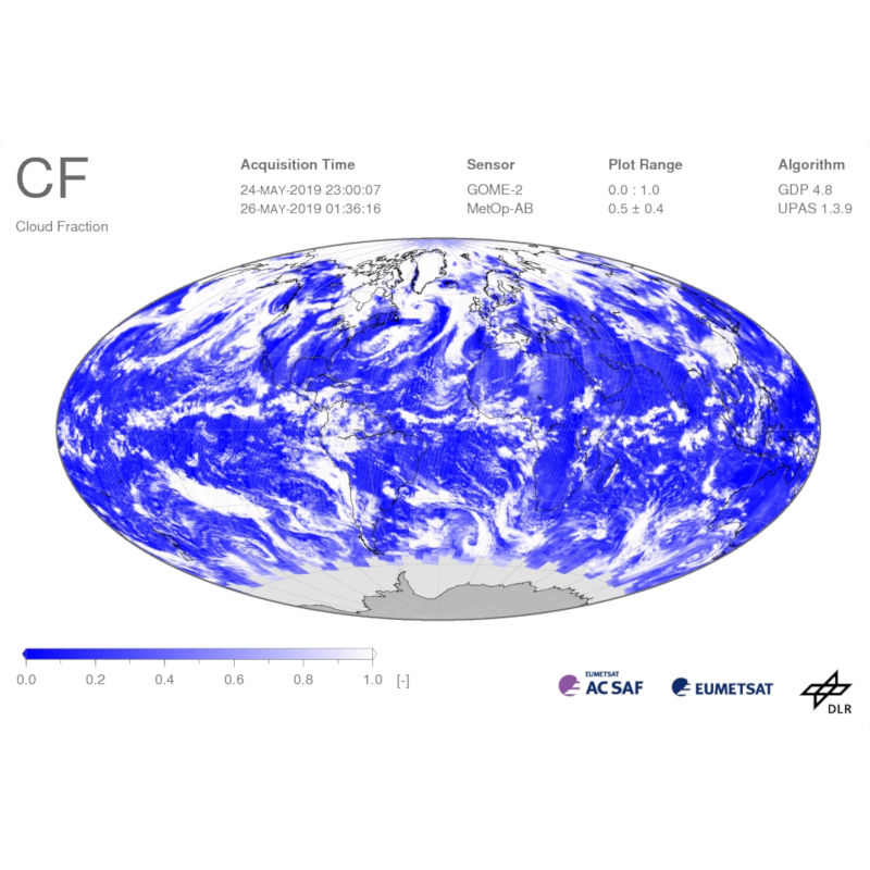
METOP GOME-2 - Cloud Fraction (CF) - Global
Gridded Level 3 cloud fraction derived from Metop/GOME observations.
Cloud physical properties (cloud fraction, cloud top height, cloud optical thickness) are derived from GOME/GOME-2 observations using the OCRA (Optical Cloud Recognition Algorithm) and ROCINN (Retrieval of Cloud Information using Neural Networks). For more details please refer to relevant peer-review papers listed on the GOME and GOME-2 documentation pages: https://atmos.eoc.dlr.de/app/docs/
The Global Ozone Monitoring Experiment-2 (GOME-2) instrument continues the long-term monitoring of atmospheric trace gas constituents started with GOME / ERS-2 and SCIAMACHY / Envisat. Three instruments operate on board EUMETSAT's Meteorological Operational satellites MetOp-A, -B, and -C, launched in 2006, 2012, and 2018, respectively. GOME-2 measures a range of atmospheric trace constituents, with the emphasis on global ozone distribution. Furthermore, cloud properties and intensities of ultraviolet radiation are retrieved. These data are crucial for monitoring the atmospheric composition and the detection of pollutants.
DLR generates operational GOME-2 / MetOp products in the framework of EUMETSAT's Satellite Application Facility on Atmospheric Composition Monitoring (AC-SAF).
Simple
- Date (Creation)
- 2020-02-22T00:00:00
- Citation identifier
- https://geoservice.dlr.de/catalogue/srv/metadata/8a587870-2ad7-4626-9228-4caad2fc9246
- Presentation form
- Digital map
- Status
- On going
- Maintenance and update frequency
- Continual
- Keywords
-
-
MetOp-A
-
MetOp-B
-
MetOp-C
-
GOME-2
-
CF
-
Cloud Fraction
-
AC-SAF
-
FEDEO
-
-
GEMET - INSPIRE themes, version 1.0
-
-
Atmospheric conditions
-
- Use limitation
-
Nutzungsbedingungen: Das DLR ist nicht haftbar für Schäden, die sich aus der Nutzung ergeben. / Terms of use: DLR not liable for damage resulting from use.
- Access constraints
- Other restrictions
- Other constraints
-
License
- Use constraints
- License
- Use constraints
- Other restrictions
- Other constraints
-
Nutzungsbedingungen: Lizenz, https://geoservice.dlr.de/resources/licenses/ac_saf/AC-SAF_User_License.pdf / Terms of use: License, https://geoservice.dlr.de/resources/licenses/ac_saf/AC-SAF_User_License.pdf
- Spatial representation type
- Grid
- Denominator
- 80000000
- Language
- English
- Character set
- UTF8
- Topic category
-
- Climatology, meteorology, atmosphere
))
- Begin date
- 2007-01-23T10:16:34
- Reference system identifier
- EPSG / WGS 84 (EPSG:4326) / 7.4
- Distribution format
-
-
(
)
-
(
)
- OnLine resource
-
EOC Geoservice Map Context
(
WWW:LINK-1.0-http--link
)
EOC Geoservice Map Context (metop:gome2.tc.daily)
- OnLine resource
-
DLR-ATMOS FTP-server
(
WWW:DOWNLOAD-1.0-ftp--download
)
For data access via FTP, please register at https://acsaf.org/registration_form.html or contact helpdesk@acsaf.org .
- OnLine resource
- https://atmos.eoc.dlr.de/app/missions/gome2
- OnLine resource
-
METOPB_GOME2_L3_P1D_CF
(
OGC:WMS
)
MetOp-B GOME-2 L3 Daily CF
- OnLine resource
-
METOPC_GOME2_L3_P1D_CF
(
OGC:WMS
)
MetOp-C GOME-2 L3 Daily CF
- OnLine resource
-
METOPB_GOME2_L3_P1D_CF
(
OGC:WCS
)
MetOp-B GOME-2 L3 Daily CF
- OnLine resource
-
METOPC_GOME2_L3_P1D_CF
(
OGC:WCS
)
MetOp-C GOME-2 L3 Daily CF
- OnLine resource
- https://geoservice.dlr.de/eoc/atmosphere/wms?SERVICE=WMS&REQUEST=GetCapabilities ( OGC:WMS-http-get-capabilities )
- OnLine resource
- https://geoservice.dlr.de/eoc/atmosphere/wcs?SERVICE=WCS&REQUEST=GetCapabilities ( OGC:WCS-http-get-capabilities )
- Hierarchy level
- Series
Domain consistency
- Measure identification
- INSPIRE / Conformity_001
Conformance result
- Date (Publication)
- 2010-12-08
- Explanation
-
See the referenced specification
- Pass
- Yes
- Statement
-
Please refer to relevant peer-review papers listed on the GOME and GOME-2 documentation pages for more details on cloud fraction retrieval: https://atmos.eoc.dlr.de/app/docs/
- File identifier
- 8a587870-2ad7-4626-9228-4caad2fc9246 XML
- Metadata language
- English
- Character set
- UTF8
- Hierarchy level
- Series
- Hierarchy level name
-
Dataseries
- Date stamp
- 2026-05-12T13:11:54
- Metadata standard name
-
19115-1:2014/19139
- Metadata standard version
-
1.0
Overviews

Spatial extent
Provided by
