 My GeoNetwork catalogue
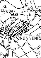
WMS HE Karten - DTK50 sw
Geobasisdaten © Hessische Verwaltung für Bodenmanagement und Geoinformation: Liegenschaftskarte, Topographische Landeskarten, Präsentationsgraphiken, Topographische Gebietskarten, Geländedarstellung:Digitale Topographische Karte 1:50 000 Schwarz_Weiß (DTK50 sw)
Simple
Identification info
- Date (Revision)
- 2026-04-24
-
mapbender.2.registryId
-
-
1c349fea-924b-488f-b6a2-e896f40ac897
-
- Keywords
-
-
Geobasisdaten
-
AdV
-
AdV-OWS-Basisprofil
-
AdV-WMS-Profil
-
WMS
-
Hessen
-
HE
-
GDI-Hessen
-
AdVMIS
-
Alkis
-
ATKIS
-
ATKIS PG
-
Präsentationsgrafik
-
Digitale Topographische Karte
-
DTK
-
infoMapAccessService
-
- Access constraints
- Other restrictions
- Other constraints
- Es gelten keine Zugriffsbeschränkungen
- Use constraints
- Other restrictions
- Other constraints
-
Der automatisierte Abruf und die Nutzung der Geobasisdaten, der Bodenrichtwerte und der zugehörigen Metadaten sind kostenfrei. (§ 24 Hessisches Vermessungs- und Geoinformationsgesetz – HVGG und § 1 Abs. 2 des Gutachterausschusskostengesetzes) - Lizenz: dl-zero-de/2.0 - Datenlizenz Deutschland – Zero – Version 2.0 - https://www.govdata.de/dl-de/zero-2-0
- Other constraints
-
{"id":"dl-zero-de/2.0","name":"Datenlizenz Deutschland \u2013 Zero \u2013 Version 2.0","url":" https://www.govdata.de/dl-de/zero-2-0"}
- Service Type
- view
- Service Version
-
OGC:WMS 1.1.1
))
- Coupling Type
- Tight
Contains Operations
- Operation Name
-
GetCapabilities
- Distributed Computing Platforms
- Web services
- Distribution format
-
- OnLine resource
-
he_dtk50_sw
(
OGC:WMS-1.1.1-http-get-map
)
Digitale Topographische Karte 1:50 000 Schwarz_Weiß (DTK50 sw)
- Hierarchy level
- Service
- Other
-
Dienst
Conformance result
- Date (Publication)
- 2010-12-08
- Explanation
-
No explanation available
- Pass
- Yes
Conformance result
- Date (Publication)
- 2009-10-20
- Explanation
-
No explanation available
- Pass
- Yes
Conformance result
- Date (Publication)
- 2014-12-11
- Explanation
-
No explanation available
- Pass
- Yes
Conformance result
- Date (Publication)
- 2008-12-04
- Explanation
-
No explanation available
- Pass
- Yes
Conformance result
- Date (Publication)
- 2014-12-11
- Explanation
-
No explanation available
- Pass
- Yes
Conformance result
- Date (Publication)
- 2013-12-10
- Explanation
-
No explanation available
- Pass
- Yes
Conformance result
- Date (Publication)
- 2011-02-05
- Explanation
-
No explanation available
- Pass
- Yes
Conformance result
- Date (Publication)
- 2010-12-08
- Explanation
-
No explanation available
- Pass
- Yes
Overviews
Spatial extent
Provided by
