 My GeoNetwork catalogue
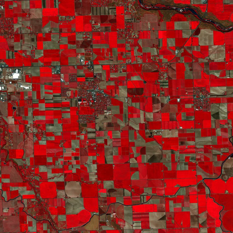
PlanetScope (RESA) - Level 1B Scene - 4 Band
The PlanetScope satellite constellation, called ‘Flock’, consists of multiple launches of groups of individual Dove satellites into a 400 km orbit. Some of them were launched from the ISS. Therefore, on-orbit capacity is constantly improving in capability or quantity. Each Dove satellite is a CubeSat with a size of 10 x 10 x 34 cm. The complete PlanetScope constellation of approximately 130 satellites is able to image the entire land surface of the Earth every day, equating to a daily collection capacity of 200 million km².
In 2014 the first Dove satellites started operationally acquiring images from the earth’s surface. The optical sensors mounted on the individual Dove satellites operate in the visual and near-infrared parts of the electromagnetic spectrum with a spatial resolution between 3 and 5 meters. A third generation of PlanetScope sensors (known as SuperDove or PSB.SD) is currently in orbit and is producing limited quantities of imagery with 5 spectral bands (BGRNIR + Red Edge). These satellites have the potential to produce imagery with 8 separate spectral bands. The PlanetScope data of this collection has been purchased by the German Space Agency with funds from the Ministry of Economy and is available for Germany-based researchers for scientific use. The data collection is maintained by the German Satellite Data Archive (D-SDA) of DLR’s Earth Observation Center and can be accessed via the EOWEB Geoportal.
This collection comprises the PlanetScope L1B Basic Scene 4-band multispectral image products with three visual RGB and one near-infrared band. The Basic Scene product is a scaled Top of Atmosphere Radiance (at sensor) and sensor corrected product, providing imagery as seen from the spacecraft without correction for any geometric distortions. It has a scene-based framing, and is not mapped to a cartographic projection. If available, the Surface Reflectance layer which corrects for the effects of the Earth's atmosphere is added to the product.
- Identification
- Distribution
- Quality
- Spatial rep.
- Ref. system
- Content
- Portrayal
- Metadata
- Md. constraints
- Md. maintenance
- Schema info
Identification
Data identification
Citation
- Date (Creation)
- 2021-07-30T12:00:00
- Citation identifier
- https://geoservice.dlr.de/catalogue/srv/metadata/8f39ddee-1273-4792-bc62-bd13fd8a10b9
- Presentation form
- Digital image
- Status
- ongoing
- Maintenance and update frequency
- As needed
-
GEMET - INSPIRE themes, version 1.0
-
-
Orthoimagery
-
- Keywords
-
-
urn:eop:DLR:EOWEB:PlanetScope.RESA.L1B_Scene4Band
-
PlanetScope
-
Level 1B
-
4 Band
-
Optical
-
visible wavelengths
-
infrared wavelengths
-
- Use limitation
-
Nutzungseinschränkungen: Das DLR ist nicht haftbar für Schäden, die sich aus der Nutzung ergeben. / Use Limitations: DLR not liable for damage resulting from use.
Legal constraints
- Access constraints
- Other restrictions
Legal constraints
- Use constraints
- Other restrictions
- Other constraints
-
Nutzungsbedingungen / License: https://geoservice.dlr.de/resources/licenses/resa/RESA-License-Agreement-Planet-Data-en.pdf
- Spatial representation type
- Grid
- Denominator
- 7400
- Language
- English
- Character set
- UTF8
- Topic category
-
- Imagery base maps earth cover
))
Distribution
Distribution
- Distribution format
-
-
GeoTIFF
()
-
GeoTIFF
()
Digital transfer options
- OnLine resource
-
Planet Labs, Inc.
(
WWW:LINK-1.0-http--link
)
For non-scientific users
- OnLine resource
-
Planet Labs Germany GmbH – RESA
(
WWW:LINK-1.0-http--link
)
For scientific users
- OnLine resource
- EOWEB Collection
Quality
Data quality
- Hierarchy level
- Series
Domain consistency
- Measure identification
- INSPIRE / Conformity_001
Conformance result
Citation
- Date (Publication)
- 2010-12-08
- Explanation
-
See the referenced specification
- Pass
- Yes
- Statement
-
Scaled Top of Atmosphere Radiance (at sensor) and sensor corrected product.
For more details see:
https://assets.planet.com/docs/Planet_Combined_Imagery_Product_Specs_letter_screen.pdf
Ref. system
- Reference system identifier
- UTM/WGS84
Metadata
Metadata
- File identifier
- 8f39ddee-1273-4792-bc62-bd13fd8a10b9 XML
- Metadata language
- English
- Character set
- UTF8
- Hierarchy level
- Series
- Hierarchy level name
-
Dataseries
- Date stamp
- 2024-06-20T14:12:21
- Metadata standard name
-
ISO 19115-1:2014/19139
Overviews
Spatial extent
Provided by
