 My GeoNetwork catalogue
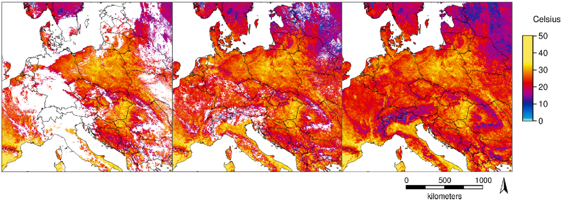
Daily gap-filled MODIS LST data (2003-2019)
Temperature time series with high spatial and temporal resolutions are important for several applications. The new MODIS Land Surface Temperature (LST) collection 6 provides numerous improvements compared to collection 5. However, being remotely sensed data in the thermal range, LST shows gaps in cloud-covered areas. With a novel method [1] we fully reconstructed the daily global MODIS LST products MOD11A1/MYD11A1 (spatial resolution: 1 km). For this, we combined temporal and spatial interpolation, using emissivity and elevation as covariates for the spatial interpolation.
The data are provided in GeoTIFF format. The Coordinate Reference System (CRS) is identical to the MOD11A1/MYD11A1 product (Sinusoidal) as provided by NASA. In WKT as reported by GDAL:
PROJCRS["unnamed",
BASEGEOGCRS["Unknown datum based upon the custom spheroid",
DATUM["Not specified (based on custom spheroid)", ELLIPSOID["Custom spheroid",6371007.181,0, LENGTHUNIT["metre",1, ID["EPSG",9001]]]],
PRIMEM["Greenwich",0, ANGLEUNIT["degree",0.0174532925199433, ID["EPSG",9122]]]], CONVERSION["unnamed",
METHOD["Sinusoidal"], PARAMETER["Longitude of natural origin",0, ANGLEUNIT["degree",0.0174532925199433], ID["EPSG",8802]],
PARAMETER["False easting",0, LENGTHUNIT["Meter",1], ID["EPSG",8806]],
PARAMETER["False northing",0, LENGTHUNIT["Meter",1], ID["EPSG",8807]]],
CS[Cartesian,2], AXIS["easting",east, ORDER[1], LENGTHUNIT["Meter",1]], AXIS["northing",north, ORDER[2], LENGTHUNIT["Meter",1]]]
Acknowledgments: We are grateful to the NASA Land Processes Distributed Active Archive Center (LP DAAC) for making the MODIS LST data available. The dataset is based on MODIS Collection V006.
Meaning of pixel values:
The pixel values are coded in Kelvin * 50
Data type: raster, UInt16
Spatial resolution: 926.62543314 m
Spatial extent Sinusoidal (W, S, E, N): 0, 4447802.079066, 2223901.039533, 6671703.118599
Spatial extent in EPSG:4326 (W, S, E, N): 0, 40, 40, 60
[1] Metz M., Andreo V., Neteler M. (2017): A new fully gap-free time series of Land Surface Temperature from MODIS LST data. Remote Sensing, 9(12):1333. DOI: http://dx.doi.org/10.3390/rs9 121333
Simple
- Date (Publication)
- 2019-03-05
- Citation identifier
-
dataset
- Status
- On going
- Maintenance and update frequency
- As needed
- Temporal
-
-
land surface temperature
-
-
Continents, countries, sea regions of the world.
-
-
World
-
- Theme
-
-
MOOD-H2020
-
-
GEMET - INSPIRE themes, version 1.0
-
-
Meteorological geographical features
-
- Use limitation
-
None
- Access constraints
- Other restrictions
- Use constraints
- License
- Other constraints
- no limitations to public access
- Other constraints
-
Open Data Commons Open Database License v1.0 (ODbL)
- Other constraints
-
{ "id": "odbl", "name": "Open Data Commons Open Database License (ODbL)", "url": " http://www.opendefinition.org/licenses/odc-odbl ", "quelle": "Source: mundialis GmbH & Co. KG" }
- Aggregate Datasetindentifier
- c0009947-e04e-4f5e-b9cb-79ae1f90608a
- Association Type
- Cross reference
- Aggregate Datasetindentifier
- 0a593dc6-8808-417c-ab2c-06b5a6be500f
- Association Type
- Cross reference
- Spatial representation type
- Grid
- Denominator
- 3
- Distance
- 1000 meters
- Language
- English
- Character set
- UTF8
- Topic category
-
- Environment
- Geoscientific information
- Health
- Climatology, meteorology, atmosphere
- Begin date
- 2003-01-01
- End date
- 2019-03-29
- Description
-
global
))
- Reference system identifier
- Sinusoidal
- Distribution format
-
-
GeoTIFF
(
)
-
GeoTIFF
(
)
- OnLine resource
-
Daily gap-filled MODIS LST data (2003-2019)
(
WWW:LINK-1.0-http--link
)
data upon request
- Hierarchy level
- Dataset
Conformance result
- Date (Publication)
- 2010-12-08
- Explanation
-
See specified reference
- Pass
- Yes
- Statement
-
Dataset has been gap-filled from the original MODIS LST products MOD11A1/MYD11A1 at a spatial resolution of 1km
- Description
-
mundialis gap-filling processor for MODIS LST
- File identifier
- 8f4ed617-1783-48fb-a0b6-6e817a0fc7ee XML
- Metadata language
- English
- Character set
- UTF8
- Hierarchy level
- Dataset
- Date stamp
- 2022-11-10T11:00:29
- Metadata standard name
-
ISO 19115:2003/19139
- Metadata standard version
-
1.0
Overviews
Spatial extent
Provided by
