 My GeoNetwork catalogue
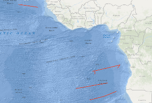
Processed seismic data of Cruise BGR91 1991
The BGR 1991 cruise with M.V. BIN HAI 511 was designed to study the variability of the oceanic crustal structure along flow-line profiles perpendicular to the ridge axis over Early Tertiary through Cretaceous old oceanic crust of the eastern Atlantic Ocean. Seismic data with a coverage of 3,000 % were acquired along four flow-line profiles with a total length of 4,194 km, and in addition 270 km of MCS data were collected during the period from 2nd October to the 3rd November 1991. The most intriguing new observation from the seismic flow-line profiles is the discovery of two huge oceanic crustal structures characterized by an internally divergent to planar pattern of reflectors having ubiquitous seaward dip. These remarkable structures were found within an about 1,300 km long oceanic crust segment of the eastern South Atlantic located between the Bode Verde Fracture zone in the north and the Rio Grande Fracture Zone in the south. These structures resemble the prominent wedges of seaward dipping reflectors on the widespread volcanic rifted continental margins described in the literature. They are interpreted to represent voluminous build-ups of layered extrusive rocks formed during three excessive episodes of volcanism that accompanied the Cretaceous opening of the South Atlantic. These episodes of excessive volcanism/magmatism are: An episode immediate prior to, and during the first stage of seafloor spreading in the South Atlantic, i.e. during about Hauterivian through about early Aptian; an episode of inferred subaerial and/or shallow marine volcanism along the central South Atlantic spreading ridge during the Albian; and an episode of inferred subaerial and/or shallow marine volcanism along the South Atlantic spreading ridge during latest Cenomanian/earliest Turonian through early Campanian.
- Identification
- Distribution
- Quality
- Spatial rep.
- Ref. system
- Content
- Portrayal
- Metadata
- Md. constraints
- Md. maintenance
- Schema info
Identification
Data identification
Citation
- Alternate title
-
BGR91 1991
- Date (Creation)
- 1991-11-03
- Citation identifier
- 9159b25b-42a2-6fbb-9c74-95abb96b64df
- Status
- Completed
-
GEMET - INSPIRE themes, version 1.0
-
-
Geologie
-
geology
-
-
GEMET - Concepts, version 2.4
-
-
geophysics
-
Geophysik
-
raw material
-
Rohstoff
-
- Theme
-
-
Marine geology
-
Meeresgeologie
-
Seismics
-
Seismik
-
Two-dimensional seismic reflection
-
zweidimensionale Reflektionsseismik
-
- Place
-
-
West Africa
-
Westafrika
-
Angola Basin
-
Angola-Becken
-
Namibia
-
Südatlantik
-
South Atlantic Ocean
-
Legal constraints
- Access constraints
- Other restrictions
- Other constraints
- Es gelten keine Zugriffsbeschränkungen
Legal constraints
- Use constraints
- Other restrictions
- Other constraints
-
Allgemeine Geschäftsbedingungen, siehe http://www.bgr.bund.de/AGB - General terms and conditions, see http://www.bgr.bund.de/AGB_en . Die bereitgestellten Informationen sind bei Weiterverwendung wie folgt zu zitieren: Datenquelle: BGR91 1991, (c) BGR, Hannover, 1991
- Spatial representation type
- Vector
- Language
- English
- Character set
- UTF8
- Topic category
-
- Geoscientific information
))
Distribution
Distribution
- Distribution format
-
-
Shapefile
(
n/a
)
-
Shapefile
(
n/a
)
Digital transfer options
- Transfer size
- 2
- OnLine resource
-
BGR91 1991 (Shapefile)
BGR91 1991 im Format ESRI Shape
- OnLine resource
- Karte im BGR-Geoviewer
Quality
Data quality
Scope
- Hierarchy level
- Dataset
Conformance result
Citation
- Date (Publication)
- 2010-12-08
- Explanation
-
siehe dazu die angegebene Durchführungsbestimmung
- Statement
-
During the period from the 2nd October to the 3rd November 1991 BGR acquired seismic lines off West Africa and in the Angola Basin. The lines BGR91-01, BGR91-02, BGR91-03, BGR91-04 and BGR91-06 are raw data. The lines BGR91-02A and BGR91-05 are processed (migrated) data.
Ref. system
- Unique resource identifier
- EPSG:4326
Metadata
Metadata
- File identifier
- 90e51e5d-551b-4a84-900d-10ed5d90ba9f XML
- Metadata language
- English
- Character set
- UTF8
- Parent identifier
-
Marine Seismic Survey Profiles (MSSP)
06a73c56-06a2-40d8-b806-466222b0760d
- Hierarchy level
- Dataset
- Hierarchy level name
-
Geophysik
- Date stamp
- 2023-11-14
- Metadata standard name
-
INSPIRE Metadata Implementing Rules: Technical Guidelines based on EN ISO 19115 and EN ISO 19119
- Metadata standard version
-
n/a
Overviews
Spatial extent
Provided by
