 My GeoNetwork catalogue
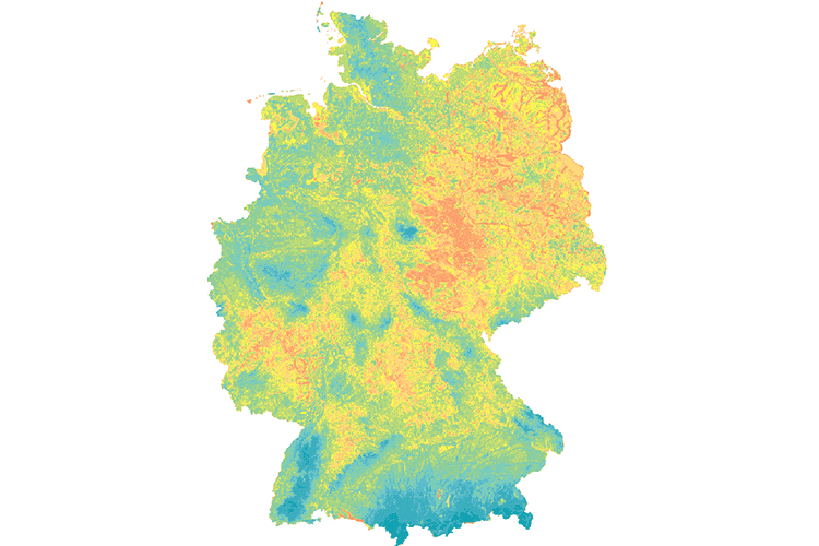
Mean Annual Groundwater Recharge of Germany 1:1,000,000 (GWN1000)
The map shows the average annual groundwater recharge of Germany for the period 1961 - 1990 as a raster image in a cell range of 1 x 1 km. For this purpose, a multi-step regression model was developed (Neumann, J. 2005). In a first step, the baseflow index (BFI = baseflow / total runoff) was determined as the regression target size as a function of slope gradient, drainage density, land cover, available field capacity, depth to groundwater and the ratio of direct runoff to total runoff. Based on this, two different model variants were developed for low-drainage (R < 200 mm/a) and high-drainage regions (R > 200 mm / a). For R < 200 mm/a, groundwater recharge rates were calculated by multiplying the regional grid-based baseflow index and the area-differentiated total runoff according to BAGLUVA. For the higher values R > 200 mm/a, a second regression equation has been used which, in addition to the base flow index, also requires the BAGLUVA total runoff and the depth to groundwater.
INSPIRE
Identification
- File identifier
- 91DB02B4-48A2-4BE3-81E8-99F400108491 XML
- Hierarchy level
- Dataset
Online resource
Resource identifier
- code
-
1542502F-0FB5-4230-9B29-2CAFBEA059D8
- Metadata language
- Deutsch
- Spatial representation type
- Grid
Encoding
- Format
-
TIFF
- Version
-
n/a
Projection
- code
- EPSG:25833
Classification of data and services
- Topic category
-
- Geoscientific information
Classification of data and services
Coupled resource
Coupled resource
Classification of data and services
Coupled resource
Coupled resource
Keywords
-
GEMET - INSPIRE themes, version 1.0
-
-
Geologie
-
-
GEMET - Concepts, version 2.4
-
-
Grundwasser
-
Hydrogeologie
-
Other keywords
- Theme
-
-
Mittlere jährliche Grundwasserneubildung
-
HAD
-
HAD 5.5
-
GWN
-
HK1000
-
- Place
-
-
Deutschland
-
Geographic coverage
))
Temporal reference
Temporal extent
Temporal extent
- Date (Publication)
- 2019-08-15
Quality and validity
- Lineage
-
-
- Denominator
- 1000000
Conformity
Conformity
Conformity
Conformity
Conformity
Conformity
Restrictions on access and use
- Access constraints
- Es gelten keine Zugriffsbeschränkungen
- Access constraints
-
Allgemeine Geschäftsbedingungen, siehe https://www.bgr.bund.de/AGB - General terms and conditions, see https://www.bgr.bund.de/AGB_en . Die bereitgestellten Informationen sind bei Weiterverwendung wie folgt zu zitieren: Datenquelle: GWN1000 (c) BGR Hannover 2019
Responsible organization (s)
Contact for the resource
- Organisation name
-
Bundesanstalt für Geowissenschaften und Rohstoffe (BGR)
Responsible organization (s)
Contact for the resource
- Organisation name
-
Bundesanstalt für Geowissenschaften und Rohstoffe (BGR)
Metadata information
Contact for the metadata
- Organisation name
-
Bundesanstalt für Geowissenschaften und Rohstoffe (BGR)
- Date stamp
- 2025-03-10
- Metadata language
- Deutsch
- Character set
- UTF8
SDS
Conformance class 1: invocable
Access Point URL
Endpoint URL
Technical specification
Conformance class 2: interoperable
Access constraints
Limitation
Use constraints
Limitation
Responsible custodian
Contact for the resource
Overviews
Spatial extent
Provided by
