 My GeoNetwork catalogue
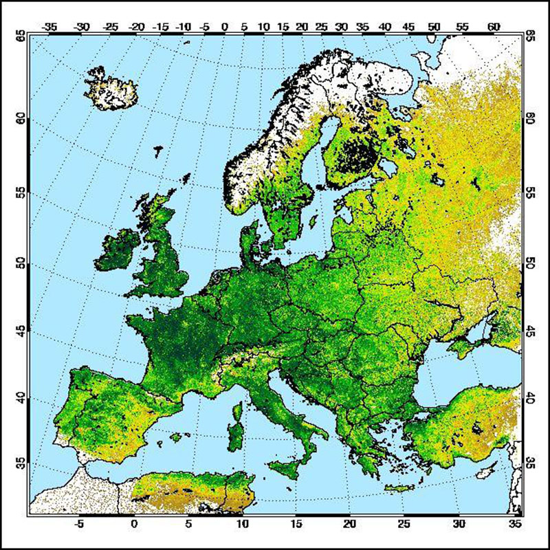
MERIS - Vegetation Index (NDVI) - Europe, 10-Day
The "AVHRR compatible Normalized Difference Vegetation Index derived from MERIS data (MERIS_AVHRR_NDVI)" was developed in a co-operative effort of DLR (German Remote Sensing Data Centre, DFD) and Brockmann Consult GmbH (BC) in the frame of the MAPP project (MERIS Application and Regional Products Projects). For the generation of regional specific value added MERIS level-3 products, MERIS full-resolution (FR) data are processed on a regular (daily) basis using ESA standard level-1b and level-2 data as input. The regular reception of MERIS-FR data is realized at DFD ground station in Neustrelitz.
The Medium Resolution Imaging MERIS on Board ESA's ENVISAT provides spectral high resolution image data in the visible-near infrared spectral region (412-900 nm) at a spatial resolution of 300 m. For more details on ENVISAT and MERIS see http://envisat.esa.int The Advanced Very High Resolution Radiometer (AVHRR) compatible vegetation index (MERIS_AVHRR_NDVI) derived from data of the MEdium Resolution Imaging Spectrometer (MERIS) is regarded as a continuity index with 300 meter resolution for the well-known Normalized Difference Vegetation Index (NDVI) derived from AVHRR (given in 1km spatial resolution). The NDVI is an important factor describing the biological status of canopies. This product is thus used by scientists for deriving plant and canopy parameters. Consultants use time series of the NDVI for advising farmers with best practice.
For more details the reader is referred to
http://wdc.dlr.de/sensors/meris/ and http://wdc.dlr.de/sensors/meris/documents/Mapp_ATBD_final_i3r0dez2001.pdf
This product provides 10-days maps.
Simple
- Date (Creation)
- 2016-01-13T00:00:00
- Citation identifier
- https://geoservice.dlr.de/catalogue/srv/metadata/93587051-2f12-4d37-a97b-520af56144ce
- Presentation form
- Digital map
- Status
- Completed
- Maintenance and update frequency
- Not planned
-
GEMET - INSPIRE themes, version 1.0
-
-
Land cover
-
- Keywords
-
-
ENVISAT
-
MERIS
-
Europe
-
Vegetation index
-
10-days
-
NDVI
-
urn:eop:DLR:EOWEB:Vegetation_Index_MERIS_10-days_maps
-
FEDEO
-
- Access constraints
- License
- Use constraints
- Other restrictions
- Other constraints
-
Nutzungsbedingungen: CC BY-SA 'Attribution ShareAlike' https://creativecommons.org/licenses/by-sa/4.0/legalcode
Reference for the use of MERIS products in publications: Products generated by DLR-DFD
- Use limitation
-
Nutzungseinschränkungen: DLR not liable for damage resulting from use
- Spatial representation type
- Grid
- Denominator
- 600000
- Language
- English
- Character set
- UTF8
- Topic category
-
- Environment
))
- Begin date
- 2003-10-15T08:22:30
- End date
- 2010-03-10T12:09:12
- Reference system identifier
- EPSG / ETRS89 / LAEA Europe (EPSG:3035) / 8.6
- Distribution format
-
- OnLine resource
-
MERIS - Vegetation Index (NDVI) - Europe, 10-Day
(
WWW:LINK-1.0-http--link
)
EOWEB GeoPortal Collection
- Hierarchy level
- Series
Domain consistency
- Measure identification
- INSPIRE / Conformity_001
Conformance result
- Date (Publication)
- 2010-12-08
- Explanation
-
See the referenced specification
- Pass
- Yes
- Statement
-
For further information see: http://wdc.dlr.de/sensors/meris/ and http://wdc.dlr.de/sensors/meris/documents/Mapp_ATBD_final_i3r0dez2001.pdf
- Description
-
Günther, Kurt P. und Maier, Stefan W. (2007) AVHRR compatible vegetation index derived from MERIS data. International Journal of Remote Sensing, 28 (3-4), 693-708.
- File identifier
- 93587051-2f12-4d37-a97b-520af56144ce XML
- Metadata language
- English
- Character set
- UTF8
- Hierarchy level
- Series
- Hierarchy level name
-
Dataseries
- Date stamp
- 2024-09-27T14:02:49
- Metadata standard name
-
ISO 19115-1:2014/19139
- Metadata standard version
-
1.0
Overviews
Spatial extent
Provided by
