 My GeoNetwork catalogue
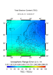
SWACI - Total Electron Content (TEC) Level 2 - Europe
SWACI is a research project of DLR supported by the State Government of Mecklenburg-Vorpommern. Radio signals, transmitted by modern communication and navigation systems may be heavily disturbed by space weather hazards. Thus, severe temporal and spatial changes of the electron density in the ionosphere may significantly degrade the signal quality of various radio systems which even may lead to a complete loss of the signal. By providing specific space weather information, in particular now- and forecast of the ionospheric state, the accuracy and reliability of impacted communication and navigation systems shall be improved.
The total electron content (TEC) is defined as the integral of the electron density along the ray path between satellite and receiver. Thus, TEC provides the number of electrons per square meter. The most frequently used unit is 1TECU = 1x10¹⁶ electrons / m2.
TEC is derived from dual frequency code and carrier phase measurements provided by Global Navigation Satellite Systems (GNSS). SWACI uses GPS measurements from various European GNSS networks such as the International GNSS Service (IGS), European Reference Frame (EUREF), Norwegian Mapping Authority (NMA), and ascos distributed by the Federal Agency of Cartography and Geodesy (BKG) Frankfurt. The global TEC maps are mainly created by using data provided by the International GNSS Service Real-Time Pilot Project (IGS-RTPP).
To generate TEC maps of vertical TEC, the slant measurements have to be transformed to the vertical. In a first approximation the ionospheric range error in GNSS is proportional to TEC.
These TEC maps are used to derive latitudinal and zonal gradients, rate of change of TEC (5 min increments), 27 days medians, hourly forecasts of TEC, and corresponding error estimates.
Spatial resolution (latitude x longitude): 2 °x 2° (Europe), 2.5° x 5° (globally)
Simple
- Date (Creation)
- 2015-03-10T00:00:00
- Citation identifier
- https://geoservice.dlr.de/catalogue/srv/metadata/9520a2d1-2e69-42e7-85ca-a902b83a93a9
- Presentation form
- Digital map
- Status
- Completed
- Maintenance and update frequency
- Not planned
-
GEMET - INSPIRE themes, version 1.0
-
-
Atmospheric conditions
-
- Keywords
-
-
urn:eop:DLR:EOWEB:SWACI.GROUNDBASED.TEC.EU.L2
-
SWACI
-
total electron content
-
Ionosphere
-
TEC
-
EU
-
- Use limitation
-
Conditional
- Access constraints
- Other restrictions
- Use constraints
- License
- Other constraints
-
Limited for public use
SWACI License
- Spatial representation type
- Grid
- Denominator
- 0
- Language
-
eng
- Character set
- UTF8
- Topic category
-
- Climatology, meteorology, atmosphere
))
- Begin date
- 2011-01-02T00:00:00
- End date
- 2015-01-09T00:00:00
- Reference system identifier
- EPSG / WGS 84 (EPSG:4326) / 7.4
- Distribution format
-
- OnLine resource
- Ionosphere Monitoring and Prediction Center Homepage ( WWW:LINK-1.0-http--link )
- Hierarchy level
- Series
Domain consistency
- Measure identification
- INSPIRE / Conformity_001
Conformance result
- Date (Publication)
- 2010-12-08
- Explanation
-
See the referenced specification
- Pass
- Yes
- Statement
-
For details see:
- Description
-
Please refer to https://impc.dlr.de/products/ for more details.
- File identifier
- 9520a2d1-2e69-42e7-85ca-a902b83a93a9 XML
- Metadata language
- English
- Character set
- UTF8
- Hierarchy level
- Series
- Hierarchy level name
-
Dataseries
- Date stamp
- 2024-06-20T14:12:14
- Metadata standard name
-
ISO 19115-1:2014/19139
- Metadata standard version
-
1.0
Overviews

Spatial extent
Provided by
