 My GeoNetwork catalogue
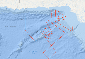
Processed seismic data of Cruise SO122 1997
The Sonne Cruise SO122 was carried out by the Federal Institute for Geosciences and Natural Resources (BGR, Hannover) from 3rd August to 9th September 1997, in cooperation with GEOMAR (Kiel), the National Institute of Oceanography (NIO, Karachi) and the Hydrocarbon Development Institute of Pakistan (HDIP). During the joint project with R/V SONNE the Makran accretionary wedge off Pakistan should have been investigated in detail with multi-channel reflection seismics, magnetics and gravimetry. Intense fishery offshore Pakistan forced a change of the area of investigation to the south with the following objectives: investigation of the crustal structure and occurrence of the bottom simulating reflector (BSR) in the Makran accretionary wedge; investigation of the structure of the Murray Ridge System in order to reconstruct the geodynamic evolution of the eastern Indian Plate margin; determination of the origin of the crust underlying the Indus Fan and reconnaissance of the sedimentary history of the Indus Fan in order to reveal the uplift and erosion history of the Himalayas.
Simple
- Alternate title
-
SO122 1997
- Date (Creation)
- 1997-09-06
- Citation identifier
- 59e92fcc-a286-f3d8-baa1-ba4abfaf2a0f
- Status
- Completed
-
GEMET - INSPIRE themes, version 1.0
-
-
Geologie
-
geology
-
-
GEMET - Concepts, version 2.4
-
-
geophysics
-
Geophysik
-
raw material
-
Rohstoff
-
- Theme
-
-
Marine geology
-
Meeresgeologie
-
Seismics
-
Seismik
-
Two-dimensional seismic reflection
-
zweidimensionale Reflektionsseismik
-
- Place
-
-
Pakistan
-
Arabian Sea
-
Indian Ocean
-
- Access constraints
- Other restrictions
- Other constraints
- Es gelten keine Zugriffsbeschränkungen
- Use constraints
- Other restrictions
- Other constraints
-
Allgemeine Geschäftsbedingungen, siehe http://www.bgr.bund.de/AGB - General terms and conditions, see http://www.bgr.bund.de/AGB_en . Die bereitgestellten Informationen sind bei Weiterverwendung wie folgt zu zitieren: Datenquelle: SO122 1997, (c) BGR, Hannover, 1997
- Spatial representation type
- Vector
- Language
- English
- Character set
- UTF8
- Topic category
-
- Geoscientific information
))
- Unique resource identifier
- EPSG:4326
- Distribution format
-
-
Shapefile
(
n/a
)
-
Shapefile
(
n/a
)
- Transfer size
- 2
- OnLine resource
-
SO122 1997 (Shapefile)
SO122 1997 im Format ESRI Shape
- OnLine resource
- Profile SO122-03
- OnLine resource
- Profile SO122-04
- OnLine resource
- Profile SO122-04A
- OnLine resource
- Profile SO122-08
- OnLine resource
- Profile SO122-09
- OnLine resource
- Profile SO122-10
- OnLine resource
- Profile SO122-11
- OnLine resource
- Profile SO122-12
- OnLine resource
- Profile SO122-13
- OnLine resource
- Profile SO122-13A
- OnLine resource
- Profile SO122-14
- OnLine resource
- Profile SO122-15
- OnLine resource
- Profile SO122-16
- OnLine resource
- Profile SO122-17
- OnLine resource
- Profile SO122-18
- OnLine resource
- Profile SO122-19
- OnLine resource
- Profile SO122-19A
- OnLine resource
- Profile SO122-19B
- OnLine resource
- Profile SO122-21
- OnLine resource
- Profile SO122-22
- OnLine resource
- Profile SO122-23
- OnLine resource
- Profile SO122-24
- OnLine resource
- Profile SO122-25
- OnLine resource
- Profile SO122-26
- OnLine resource
- Profile SO122-27
- OnLine resource
- Karte im BGR-Geoviewer
- Hierarchy level
- Dataset
Conformance result
- Date (Publication)
- 2010-12-08
- Explanation
-
siehe dazu die angegebene Durchführungsbestimmung
- Statement
-
During the period from 3rd August to 6th September 1997 BGR acquired seismic lines off Pakistan. The lines SO122-03, SO122-04, SO122-04A, SO122-08, SO122-09, SO122-10, SO122-11, SO122-12, SO122-13, SO122-13A, SO122-14, SO122-15, SO122-16, SO122-17, SO122-18, SO122-19, SO122-19A, SO122-19B, SO122-21, SO122-22, SO122-23, SO122-24, SO122-25, SO122-26, SO122-27 are processed (migrated) data.
- File identifier
- 954e6fb9-99f3-455a-8e04-9205843f2fa8 XML
- Metadata language
- English
- Character set
- UTF8
- Parent identifier
-
Marine Seismic Survey Profiles (MSSP)
06a73c56-06a2-40d8-b806-466222b0760d
- Hierarchy level
- Dataset
- Hierarchy level name
-
Geophysik
- Date stamp
- 2023-11-16
- Metadata standard name
-
INSPIRE Metadata Implementing Rules: Technical Guidelines based on EN ISO 19115 and EN ISO 19119
- Metadata standard version
-
n/a
Overviews
Spatial extent
Provided by
