 My GeoNetwork catalogue
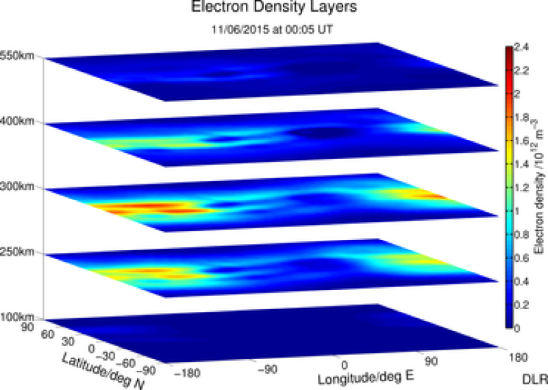
SWACI - Electron Density Distribution (REG) - Global
SWACI is a research project of DLR supported by the State Government of Mecklenburg-Vorpommern. Radio signals, transmitted by modern communication and navigation systems may be heavily disturbed by space weather hazards. Thus, severe temporal and spatial changes of the electron density in the ionosphere may significantly degrade the signal quality of various radio systems which even may lead to a complete loss of the signal. By providing specific space weather information, in particular now- and forecast of the ionospheric state, the accuracy and reliability of impacted communication and navigation systems shall be improved.
According to the pioneer work of Sir E. Appleton the vertical structure of the terrestrial ionosphere may be divided into different layers (D, E, F1, F2) with different physical characteristics. The layers are primarily characterized by its height and peak electron density.
The spatial plasma distribution is generated from actual TEC maps by applying a first version of the empirical electron density model NEDM-v1. In correspondence with the update rate of TEC maps the time resolution of the 3 D images is 5 minutes.
For details see http://swaciweb.dlr.de/index.php?id=303&L= 1 and http://presentations.copernicus.org/EGU2011-7324_presentation.pdf .
- Identification
- Distribution
- Quality
- Spatial rep.
- Ref. system
- Content
- Portrayal
- Metadata
- Md. constraints
- Md. maintenance
- Schema info
Identification
Data identification
Citation
- Date (Creation)
- 2015-05-06T00:00:00
- Citation identifier
- https://geoservice.dlr.de/catalogue/srv/metadata/96153ce9-a5f8-4868-b8b3-b44f3392abe0
- Presentation form
- Digital map
- Status
- On going
- Maintenance and update frequency
- Not planned
-
GEMET - INSPIRE themes, version 1.0
-
-
Atmospheric conditions
-
- Keywords
-
-
urn:eop:DLR:EOWEB:SWACI.GROUNDBASED.REC.GB.L2
-
SWACI
-
global electron density distribution
-
Ionosphere
-
REC
-
- Use limitation
-
Conditional
Legal constraints
- Access constraints
- Other restrictions
- Use constraints
- License
- Other constraints
-
Limited for public use
SWACI License
- Spatial representation type
- Grid
- Denominator
- 0
- Language
-
eng
- Character set
- UTF8
- Topic category
-
- Climatology, meteorology, atmosphere
Extent
))
- Begin date
- 2011-01-13T00:00:00
Distribution
Distribution
- Distribution format
-
- OnLine resource
- Ionosphere Monitoring and Prediction Center Homepage ( WWW:LINK-1.0-http--link )
Quality
Data quality
- Hierarchy level
- Series
Domain consistency
- Measure identification
- INSPIRE / Conformity_001
Conformance result
Citation
- Date (Publication)
- 2010-12-08
- Explanation
-
See the referenced specification
- Pass
- Yes
Lineage
- Statement
-
For details see:
- Description
-
Please refer to https://impc.dlr.de/products/ for more details.
Spatial rep.
Grid spatial representation
- Number of dimensions
- 3
Dimension
- Dimension name
- Row
- Dimension size
- 1
Dimension
- Dimension name
- Column
- Dimension size
- 1
Dimension
- Dimension name
- Vertical
- Dimension size
- 1
- Cell geometry
- Area
- Transformation parameter availability
- No
Ref. system
- Reference system identifier
- EPSG / WGS 84 (EPSG:4326) / 7.4
Metadata
Metadata
- File identifier
- 96153ce9-a5f8-4868-b8b3-b44f3392abe0 XML
- Metadata language
- English
- Character set
- UTF8
- Hierarchy level
- Series
- Hierarchy level name
-
Dataseries
- Date stamp
- 2024-06-20T14:12:14
- Metadata standard name
-
ISO 19115-1:2014/19139
- Metadata standard version
-
1.0
Overviews

Spatial extent
Provided by
