 My GeoNetwork catalogue
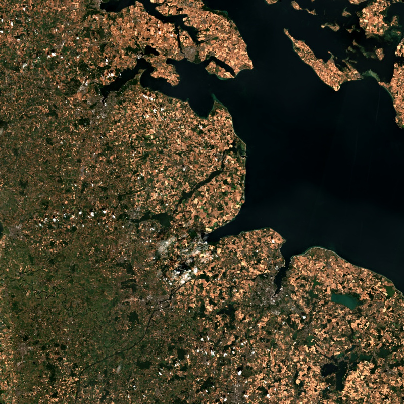
Sentinel-2 MSI - Level 2A (MAJA Tiles) - Germany
This collection contains Sentinel-2 Level 2A surface reflectances, which are computed for the country of Germany using the time-series based MAJA processor. During the Level 2A processing, the data are corrected for atmospheric effects and clouds and their shadows are detected. The MAJA L2A product is available online for the last 12 months. Further data are kept in the archive and are available upon request. Please see https://logiciels.cnes.fr/en/content/maja for additional information on the MAJA product. The MAJA product offers an alternative to the official ESA L2A product and has been processed with consideration of the characteristics of the Sentinel-2 mission (fast collection of time series, constant sensor perspective, and global coverage). Assumptions about the temporal constancy of the ground cover are taken into account for a robust detection of clouds and a more flexible determination of aerosol properties. As a result, an improved determination of the reflectance of sunlight at the earth's surface (pixel values of the multispectral image) is derived. Further Sentinel-2 Level 2A data computed using MAJA are available on the following website: https://theia.cnes.fr
Simple
- Date (Creation)
- 2018-06-11T08:12:00
- Citation identifier
- https://geoservice.dlr.de/catalogue/srv/metadata/97f6e84c-5db2-4121-b257-d3318cedc059
- Presentation form
- Digital image
- Other citation details
-
DOI: 10.15489/ifczsszkcp63
- Status
- On going
- Maintenance and update frequency
- Continual
- Keywords
-
-
Satellite
-
Earth Observation
-
Multispectral
-
Sentinel-2
-
MSI
-
Level 2A
-
MAJA
-
DLR
-
Atmospheric Correction
-
Cloud Detection
-
Germany
-
-
GEMET - INSPIRE themes, version 1.0
-
-
Orthoimagery
-
- Use limitation
-
Nutzungseinschränkungen: Das DLR ist nicht haftbar für Schäden, die sich aus der Nutzung ergeben. / Use Limitations: DLR not liable for damage resulting from use.
- Access constraints
- Other restrictions
- Other constraints
- Es gelten keine Zugriffsbeschränkungen
- Use constraints
- Other restrictions
- Other constraints
-
Nutzungsbedingungen / Terms of use: The Sentinel-2 level 2A data produced and distributed by DLR are based on Copernicus Sentinel-2 level 1C data, which are subject to the following license: https://theia.cnes.fr/atdistrib/documents/TC_Sentinel_Data_31072014.pdf
- Other constraints
-
{"id": "cc-by-4.0",
"name": "Creative Commons Namensnennung 4.0 International (CC BY 4.0)",
"url": " https://www.dcat-ap.de/def/licenses/ ",
"quelle": "German Aerospace Center (DLR): Sentinel-2 MSI - Level 2A (MAJA Tiles) - Germany, DOI: 10.15489/ifczsszkcp63 or Contains modified Copernicus Sentinel data, processed by DLR, licensed under CC BY 4.0"}
- Spatial representation type
- Grid
- Denominator
- 20000
- Language
- English
- Character set
- UTF8
- Topic category
-
- Imagery base maps earth cover
))
- Begin date
- 2015-07-01T00:00:00
- Unique resource identifier
- EPSG:4326
- Number of dimensions
- 2
- Dimension name
- Column
- Dimension size
- 74592
- Resolution
- 10 m
- Dimension name
- Row
- Dimension size
- 90211
- Resolution
- 10 m
- Cell geometry
- Area
- Transformation parameter availability
- No
- Distribution format
-
-
GeoTIFF
()
-
GeoTIFF
()
- OnLine resource
- EOC Geoservice Dataset ( WWW:LINK-1.0-http--link )
- OnLine resource
-
Identification of tile IDs for Sentinel-2
(
WWW:LINK-1.0-http--link
)
Identification of tile IDs for Sentinel-2 (note: Open tiling grid provided on the right column)
- OnLine resource
- EOC STAC Collection ( WWW:LINK-1.0-http--link )
- OnLine resource
- Description of MAJA L2A product (pdf) ( WWW:LINK-1.0-http--link )
- OnLine resource
- Description of MAJA algorithm and related reference ( WWW:LINK-1.0-http--link )
- OnLine resource
- Theia platform for downloading further MAJA L2A products ( WWW:LINK-1.0-http--link )
- OnLine resource
-
HTTP Download
(
WWW:LINK-1.0-http--link
)
HTTP download (Sentinel-2 MAJA L2A)
- OnLine resource
-
S2_L2A_MAJA_CLM_V2
(
OGC:WMS
)
WMS access: Sentinel-2 L2A CLM (MAJA)
- OnLine resource
-
S2_L2A_MAJA_FRE_V2
(
OGC:WMS
)
WMS access: Sentinel-2 L2A FRE (MAJA)
- OnLine resource
-
S2_L2A_MAJA_MG2_V2
(
OGC:WMS
)
WMS access: Sentinel-2 L2A MG2 (MAJA)
- OnLine resource
- https://geoservice.dlr.de/eoc/imagery/wms?SERVICE=WMS&REQUEST=GetCapabilities ( OGC:WMS-http-get-capabilities )
- OnLine resource
-
S2_L2A_MAJA_CLM_V2
(
OGC:WCS
)
WCS access: Sentinel-2 L2A CLM (MAJA)
- OnLine resource
-
S2_L2A_MAJA_FRE_V2
(
OGC:WCS
)
WCS access: Sentinel-2 L2A FRE (MAJA)
- OnLine resource
-
S2_L2A_MAJA_MG2_V2
(
OGC:WCS
)
WCS access: Sentinel-2 L2A MG2 (MAJA)
- OnLine resource
- https://geoservice.dlr.de/eoc/imagery/wcs?SERVICE=WCS&REQUEST=GetCapabilities ( OGC:WCS-http-get-capabilities )
- OnLine resource
-
EOC Geoservice Map Context
(
WWW:LINK-1.0-http--link
)
EOC Geoservice Map Context (sentinel2:l2a:maja)
- Hierarchy level
- Series
Domain consistency
- Measure identification
- INSPIRE / Conformity_001
Conformance result
- Date (Publication)
- 2010-12-08
- Explanation
-
See the referenced specification.
- Pass
- Yes
- Statement
-
Input data sets: Sentinel-2 L1C data, SRTM C-Band DEM
- Description
-
Sentinel-2 L2A data are generated by time-series based atmospheric correction of the MAJA software (formerly known as MACCS) using the CATENA framework at DLR. Please see the following website for further information: http://www.cesbio.ups-tlse.fr/multitemp/?p=620 3
- File identifier
- 97f6e84c-5db2-4121-b257-d3318cedc059 XML
- Metadata language
- English
- Character set
- UTF8
- Hierarchy level
- Series
- Date stamp
- 2025-07-22T13:34:30
- Metadata standard name
-
ISO19115
- Metadata standard version
-
2003/Cor.1:2006
Overviews

Spatial extent
Provided by
