 My GeoNetwork catalogue
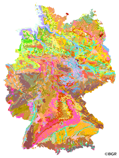
Land use-stratified soil map of Germany at scale 1:1,000,000
The Land use-stratified soil map of Germany at scale 1:1,000,000 (BUEK1000N), version 2.32, presents the distribution of soils and their associations nationwide in a uniform form at the aggregation level of the lead soil associations, which were intersected with 14 generalized and adjusted land use classes from CORINE Land Cover 1990. It did not appear as an analog map like the three subextracts of cropland, grassland, and forest. The digital map graphic is supplemented by climate regions, soil regions, and soil landscapes. The legend comprises 69 soil legend units with leading and accompanying soils (and information on the soil depth, the soil types, water conditions and the parent material), arranged according to soil distribution areas, partial legends arable land, grassland and forest, each subdivided according to climatic regions. The area-related content data are composed of 76 forest reference profiles, 78 cropland reference profiles, and 56 grassland reference profiles and are stored in a relational database. An additional 54-page booklet with explanations of the BUEK1000N can be purchased at GeoCenter Touristik Medienservice GmbH in 70565 Stuttgart, Germany, if required. The digital map graphics of version 2.32 are based on the topographic map of the Digital Landscape Model 1:1,000,000 (DLM1000) of the Federal Agency for Cartography and Geodesy from 2019.
INSPIRE
Identification
- File identifier
- 9F57D939-7BF4-4E0B-A13D-2F07009E08C1 XML
- Hierarchy level
- Dataset
Online resource
Resource identifier
- code
-
064385a1-0202-11ea-b222-10e7c63313a0
- Metadata language
- Deutsch
- Spatial representation type
- Vector
Encoding
- Format
-
GeoPackage
- Version
-
n/a
- Format
-
Shapefile
- Version
-
n/a
- Format
-
MS Access
- Version
-
n/a
Projection
- code
- EPSG:3035
Classification of data and services
- Topic category
-
- Geoscientific information
Classification of data and services
Coupled resource
Coupled resource
Classification of data and services
Coupled resource
Coupled resource
Keywords
-
GEMET - INSPIRE themes, version 1.0
-
-
Boden
-
Soil
-
-
GEMET - Concepts, version 2.4
-
-
Bodenbearbeitung
-
Bodenfeuchtigkeit
-
Bodenart
-
Bodenmineralogie
-
Bodengestaltung
-
Bodenkarte
-
Bodenfunktion
-
Bodenbelastung
-
Bodennutzung
-
Bodennutzbarkeit
-
Bodenmechanik
-
Bodenluft
-
-
SGD-Liste
-
-
Bodengruppe
-
Bodengefüge
-
Bodenskelett
-
Bodenverbreitung
-
Bodenhorizont
-
bodenphysikalische Eigenschaften
-
Bodeneigenschaften
-
-
Freies Schlagwort
-
-
Bodengesellschaft
-
Bodensubstrat
-
Bodenprofil
-
Bodentyp
-
Bodenform
-
Bodensystematik
-
Bodeninformationssystem
-
Bodenausgangsgestein
-
Bodengesellschaft
-
Fachinformationssystem
-
Other keywords
- Place
-
-
Bundesrepublik Deutschland
-
Geographic coverage
))
Temporal reference
Temporal extent
Temporal extent
- Date (Creation)
- 2005-11-09
- Date (Publication)
- 2019-11-08
- Date (Revision)
- 2022-03-17
Quality and validity
- Lineage
-
BÜK1000N V1.3 (BGR), Bodenprofile der BZE (BFH), Bodenprofile der SGD der Länder. Gesamten Datensatz um 150 Meter nach Westen und um 50 Meter nach Süden verschoben (PROJECT), Anpassung an aktuelles DLM1000 von 2019 des BKG.
- Denominator
- 1000000
Conformity
Conformity
Conformity
Conformity
Conformity
Conformity
Restrictions on access and use
- Access constraints
- Es gelten keine Zugriffsbeschränkungen
- Access constraints
-
Allgemeine Geschäftsbedingungen, siehe http://www.bgr.bund.de/AGB - General terms and conditions, see http://www.bgr.bund.de/AGB_en . Die bereitgestellten Informationen sind bei Weiterverwendung wie folgt zu zitieren: Datenquelle: BÜK1000N V2.32, (C) BGR, Hannover, 2019.
Responsible organization (s)
Contact for the resource
- Organisation name
-
Bundesanstalt für Geowissenschaften und Rohstoffe (BGR)
Responsible organization (s)
Contact for the resource
- Organisation name
-
Bundesanstalt für Geowissenschaften und Rohstoffe (BGR)
Metadata information
Contact for the metadata
- Organisation name
-
Bundesanstalt für Geowissenschaften und Rohstoffe (BGR)
- Date stamp
- 2023-08-22
- Metadata language
- Deutsch
- Character set
- UTF8
SDS
Conformance class 1: invocable
Access Point URL
Endpoint URL
Technical specification
Conformance class 2: interoperable
Access constraints
Limitation
Use constraints
Limitation
Responsible custodian
Contact for the resource
Overviews
Spatial extent
Provided by
