 My GeoNetwork catalogue
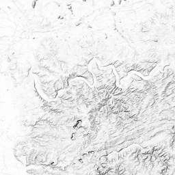
WMS basemap.de Web Raster Schummerung
Der WMS DE basemap.de Web Raster Schummerung hat als Datengrundlage das bundesweite DGM 5. Maßstab: 1:17471320, 1:8735660, 1:4367830, 1:2183915, 1:1091957, 1:545978, 1:272989, 1:136494, 1:68247, 1:34123, 1:17061, 1:8530, 1:4265, 1:2132; Bodenauflösung: nullm, nullm, nullm, nullm, nullm, nullm, nullm, nullm, nullm, nullm, nullm, nullm, nullm, nullm; Scanauflösung (DPI): null, null, null, null, null, null, null, null, null, null, null, null, null, null
Simple
Identification info
- Alternate title
-
basemap.de
- Alternate title
-
wms_basemapde_schummerung
- Date (Creation)
- 2022-07-29T00:00:00.000+02:00
+49 89 2129-21901
https://www.adv-online.de
+49 89 2129-21901
https://www.adv-online.de
+49 69 6333-251
https://www.bkg.bund.de
+49 69 6333-235
https://www.bkg.bund.de
- Maintenance and update frequency
- Irregular
- Update scope
- Service
-
Service Classification, version 1.0
-
-
infoMapAccessService
-
- Keywords
-
-
WMS
-
ViewService
-
Geobasisdaten
-
Deutschlandatlas
-
AdV
-
Bund
-
BKG
-
DE
-
basemap.de
-
Schummerung
-
Höhenschichten
-
DGM5
-
Webbasierter Atlas für Deutschland
-
AdV-OWS-Basisprofil
-
AdV-WMS-Profil 5.0.0
-
Webkarte Deutschland
-
Bundesamt für Kartographie und Geodäsie
-
Smart Mapping
-
Hintergrundkarte
-
- Keywords
-
-
AdVMIS
-
-
GEMET - Concepts, version 3.1
- Use constraints
- Other restrictions
- Other constraints
-
Die Daten sind urheberrechtlich geschützt. Die Daten werden geldleistungsfrei gemäß der Creative Commons Namensnennung 4.0 International Lizenz ( https://creativecommons.org/licenses/by/4.0/ ) zur Verfügung gestellt. Daten, die unter der Lizenz CC BY 4.0 stehen, dürfen unter einer Namensnennung geteilt, vervielfältigt und bearbeitet werden. Die Namensnennung ist im Quellenvermerk enthalten. Der Quellenvermerk ist zu beachten.
- Other constraints
-
Quellenvermerk: © GeoBasis-DE / BKG (Jahr des letzten Datenbezugs) CC BY 4.0
- Access constraints
- Other restrictions
- Other constraints
- Es gelten keine Zugriffsbeschränkungen
- Service Type
- view
- Service Version
-
OGC:WMS 1.3.0
- Extent type code
- Yes
- Geographic identifier
- Bundesrepublik Deutschland
))
- Coupling Type
- Tight
Contains Operations
- Operation Name
-
GetCapabilities
- Distributed Computing Platforms
- Web services
Contains Operations
- Operation Name
-
GetMap
- Distributed Computing Platforms
- Web services
- Operates On
- Unique resource identifier
- EPSG 3857: WGS 84 / Pseudo-Mercator
- Unique resource identifier
- EPSG 25832: ETRS89 / UTM Zone 32N
- Unique resource identifier
- EPSG 25833: ETRS89 / UTM Zone 33N
- Unique resource identifier
- EPSG 4326: WGS 84 / geographisch
- Unique resource identifier
- EPSG 4647: ETRS89 / UTM Zone 32N (zE-N)
- Distribution format
-
-
PNG
()
-
JPEG
()
-
TIFF
()
-
PNG
()
- OnLine resource
-
basemap.de Web Raster Schummerung
Produktbeschreibung auf basemap.de
- OnLine resource
- Nutzungsbedingungen
- OnLine resource
- Dokumentation
- OnLine resource
- Dienst "WMS basemap.de Web Raster Schummerung" (GetCapabilities) ( OGC Web Map Service )
- Hierarchy level
- Service
- Other
-
service
Conformance result
- Date (Publication)
- 2022-07-29
- Explanation
-
see the referenced specification
- Pass
- Yes
- File identifier
- A82E17DB-1383-45F4-A50A-59AA54A7A579 XML
- Metadata language
- Deutsch
- Character set
- UTF8
- Hierarchy level
- Service
- Hierarchy level name
-
service
- Date stamp
- 2026-05-05
- Metadata standard name
-
ISO19119
- Metadata standard version
-
2005/PDAM 1
Overviews
Spatial extent
Provided by
