 My GeoNetwork catalogue
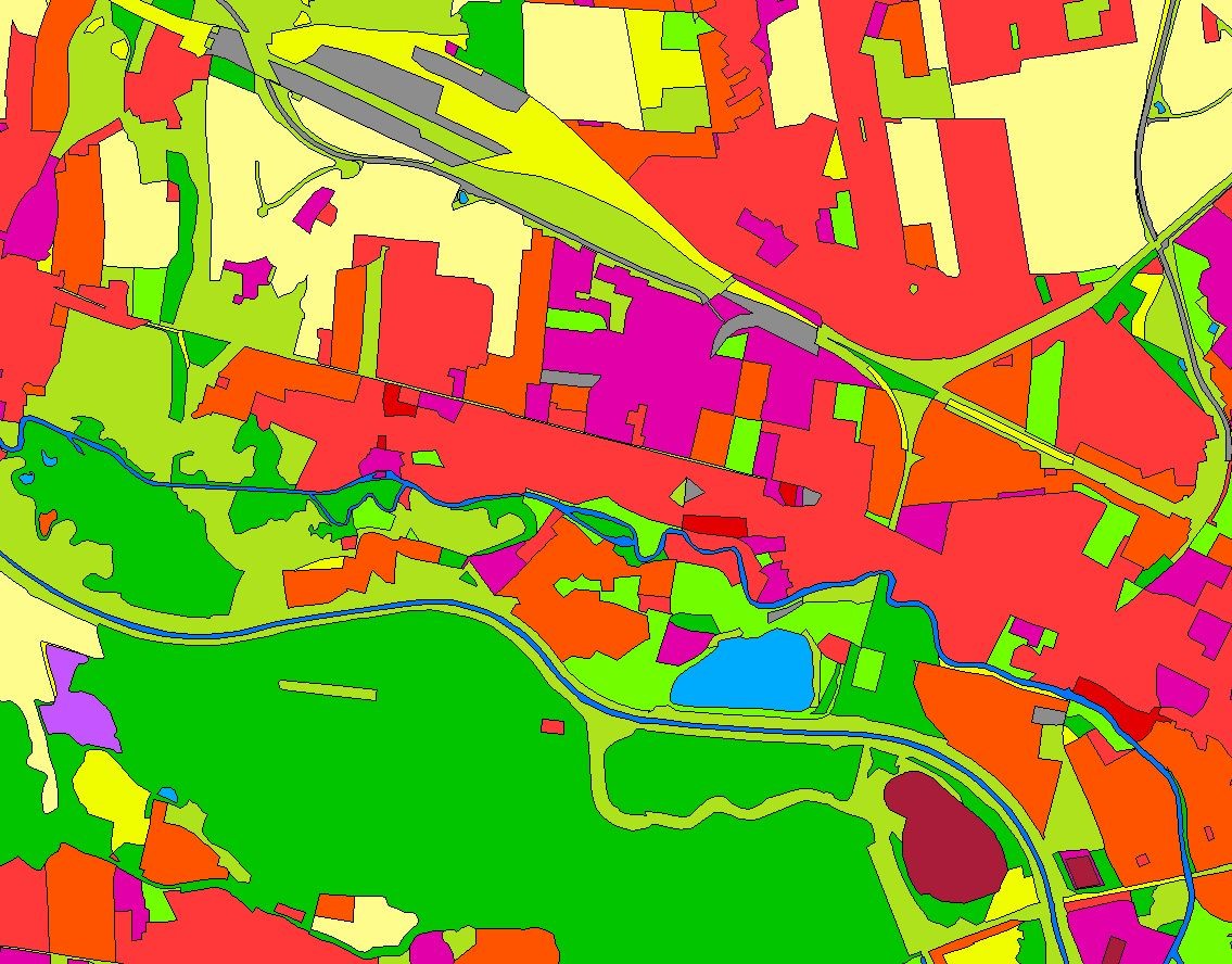
Landbedeckungsmodell für Deutschland (LBM-DE) 2021
Das Landbedeckungsmodell Deutschland (LBM-DE) besitzt eine detaillierte Gliederung in Landbedeckung (LB) und Landnutzung (LN) bei einer Mindestkartierfläche von 1ha. Aus den Kombinationen von LB und LN werden eindeutige CORINE LandCover-Klassen abgeleitet ("CLC").
Simple
- Alternate title
-
LBM-DE2021
- Date (Revision)
- 2026-03-09T00:00:00.000+01:00
- Citation identifier
- https://registry.gdi-de.org/id/de.bund.bkg.csw/638c5069-85e7-44c9-90e4-d0ccca631426
- Status
- Completed
+49 69 6333-251
https://www.bkg.bund.de
+49 69 6333-235
https://www.bkg.bund.de
- Maintenance and update frequency
- Continual
- Update scope
- Dataset
- Keywords
-
-
CLC
-
Landnutzung
-
opendata
-
-
GEMET - Concepts, version 3.1
- Use constraints
- Other restrictions
- Other constraints
-
Quellenvermerk: © BKG (Jahr des letzten Datenbezugs) CC BY 4.0, Datenquellen: https://sgx.geodatenzentrum.de/web_public/gdz/datenquellen/datenquellen_lbm-de2021.pdf
- Other constraints
-
{"id":"cc-by/4.0","name":"Creative Commons Namensnennung – 4.0 International (CC BY 4.0)","url":" https://creativecommons.org/licenses/by/4.0/","quelle":"© BKG (Jahr des letzten Datenbezugs) CC BY 4.0, Datenquellen: https://sgx.geodatenzentrum.de/web_public/gdz/datenquellen/datenquellen_lbm-de2021.pdf"}
- Access constraints
- Other restrictions
- Other constraints
- Es gelten keine Zugriffsbeschränkungen
- Denominator
- 25000
- Language
- Deutsch
- Topic category
-
- Imagery base maps earth cover
- Extent type code
- Yes
- Geographic identifier
- Bundesrepublik Deutschland
))
- Begin date
- 2021-01-01T00:00:00.000+01:00
- End date
- 2021-12-31T00:00:00.000+01:00
- Unique resource identifier
- EPSG 4258: ETRS89 / geographisch
- Unique resource identifier
- EPSG 25833: ETRS89 / UTM Zone 33N
- Unique resource identifier
- EPSG 25832: ETRS89 / UTM Zone 32N
- Unique resource identifier
- EPSG 31469: DHDN / Gauss-Krüger Zone 5
- Unique resource identifier
- EPSG 31468: DHDN / Gauss-Krüger Zone 4
- Unique resource identifier
- EPSG 31467: DHDN / Gauss-Krüger Zone 3
- Distribution format
-
-
GeoPackage
()
-
GeoPackage
()
Distributor
+49 69 6333-251
https://www.bkg.bund.de
- OnLine resource
- Produktseite des Geodatenzentrums
- OnLine resource
- Dokumentation
- OnLine resource
- Nutzungsbedingungen
- OnLine resource
- Download LBM-DE2021
- Hierarchy level
- Dataset
Absolute external positional accuracy
- Name of measure
-
Mean value of positional uncertainties (2D)
- Measure identification
- 28
- Measure description
-
geographic
Quantitative result
- Value
- 5
- Statement
-
Das BKG erstellt und aktualisiert das LBM-DE, welches auf Geobasisdaten aufsetzt und Satellitenbilder zur Aktualisierung nutzt.
- File identifier
- BBB47E1F-4E6C-4969-844A-14CAF097FD1F XML
- Metadata language
- Deutsch
- Character set
- UTF8
- Hierarchy level
- Dataset
- Date stamp
- 2026-05-05
- Metadata standard name
-
ISO19115
- Metadata standard version
-
2003/Cor.1:2006
Overviews
Spatial extent
Provided by
