 My GeoNetwork catalogue
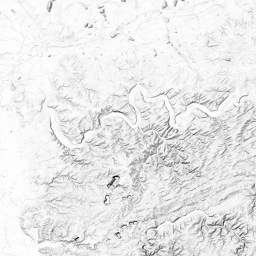
WMTS basemap.de Web Raster Schummerung
Der WMTS DE basemap.de Web Raster Schummerung hat als Datengrundlage das bundesweite DGM 5. Maßstab: 1:17471320, 1:8735660, 1:4367830, 1:2183915, 1:1091957, 1:545978, 1:272989, 1:136494, 1:68247, 1:34123, 1:17061, 1:8530, 1:4265, 1:2132; Bodenauflösung: nullm, nullm, nullm, nullm, nullm, nullm, nullm, nullm, nullm, nullm, nullm, nullm, nullm, nullm; Scanauflösung (DPI): null, null, null, null, null, null, null, null, null, null, null, null, null, null
INSPIRE
Identification
- File identifier
- D5498A65-9A7D-4640-AFFF-C4B23EF9EB11 XML
- Hierarchy level
- Service
Online resource
- Protocol
- OGC Web Map Tile Service
Resource identifier
Encoding
- Format
-
PNG
Projection
Classification of data and services
- Service Type
- view
- Coupling Type
- Tight
Coupled resource
Coupled resource
Classification of data and services
- Service Type
- view
- Coupling Type
- Tight
Coupled resource
Coupled resource
Keywords
-
Service Classification, version 1.0
-
-
infoMapAccessService
-
-
GEMET - Concepts, version 3.1
Other keywords
- Keywords
-
-
WMTS
-
ViewService
-
AdV-OWS-Basisprofil
-
AdV-WMTS-Profil 1.0.0
-
AdV
-
Bund
-
BKG
-
Bundesamt für Kartographie und Geodäsie
-
DE
-
Deutschland
-
basemap.de
-
Smart Mapping
-
Webbasierter Atlas für Deutschland
-
Webkarte Deutschland
-
Deutschlandatlas
-
Geobasisdaten
-
infoMapAccessService
-
Schummerung
-
Höhenschichten
-
DGM5
-
Hintergrundkarte
-
- Keywords
-
-
AdVMIS
-
Geographic coverage
))
Temporal reference
Temporal extent
Temporal extent
- Date (Creation)
- 2022-07-29T00:00:00.000+02:00
Conformity
Conformity
Conformity
Conformity
Conformity
Conformity
- Explanation
-
see the referenced specification
Restrictions on access and use
- Access constraints
-
Quellenvermerk: © GeoBasis-DE / BKG (Jahr des letzten Datenbezugs) CC BY 4.0
- Access constraints
- Es gelten keine Zugriffsbeschränkungen
Responsible organization (s)
Contact for the resource
- Organisation name
-
Arbeitsgemeinschaft der Vermessungsverwaltungen der Länder der Bundesrepublik Deutschland (AdV)
- Organisation name
-
Arbeitsgemeinschaft der Vermessungsverwaltungen der Länder der Bundesrepublik Deutschland (AdV)
- Organisation name
-
Zentrale Stelle Geotopographie (ZSGT) am Bundesamt für Kartographie und Geodäsie (BKG)
- Organisation name
-
Zentrale Stelle Geotopographie (ZSGT) am Bundesamt für Kartographie und Geodäsie (BKG)
Metadata information
Contact for the metadata
- Organisation name
-
Bundesamt für Kartographie und Geodäsie (BKG)
- Date stamp
- 2026-05-05
- Metadata language
- Deutsch
SDS
Conformance class 1: invocable
- Pass
- Yes
Access Point URL
Endpoint URL
Technical specification
- Date
- Explanation
-
see the referenced specification
Conformance class 2: interoperable
Access constraints
- Access constraints
- Other restrictions
- Other constraints
- Es gelten keine Zugriffsbeschränkungen
Limitation
Use constraints
- Use constraints
- Other restrictions
- Other constraints
-
Quellenvermerk: © GeoBasis-DE / BKG (Jahr des letzten Datenbezugs) CC BY 4.0
Limitation
- string
-
Quellenvermerk: © GeoBasis-DE / BKG (Jahr des letzten Datenbezugs) CC BY 4.0
Responsible custodian
Contact for the resource
Conformance class 3: harmonized
Contains Operations
- Operation Name
-
GetCapabilities
- Distributed Computing Platforms
- Web services
Overviews
Spatial extent
Provided by
