 My GeoNetwork catalogue
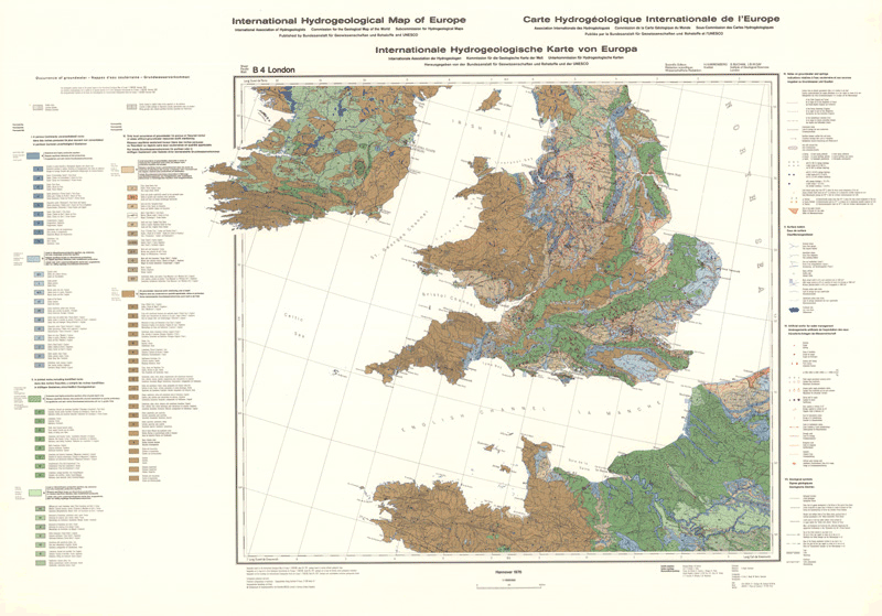
International hydrogeological map of Europe 1:1,500,000 (IHME1500) - Sheet B4 London
The International Hydrogeological Map of Europe, scale 1:1,500,000 is a series of general hydrogeological maps comprising 25 map sheets with explanatory notes, covering the whole European continent and parts of the Near East. The national contributions to this map series were compiled by hydrogeologists and experts in related sciences of the countries concerned under the auspices of the International Association of Hydrogeologists (IAH) and its Commission on Hydrogeological Maps (COHYM). The project is supported by the Commission for the Geological Map of the World (CGMW).The scientific editorial work is supported financially by the Government of the Federal Republic of Germany through the Bundesanstalt für Geowissenschaften und Rohstoffe (BGR) and by the United Nations Educational, Scientific and Cultural Organization (UNESCO). These organizations are responsible for the cartography, printing and publication of the map sheets and explanatory notes.The series of hydrogeological maps seeks to represent the hydrogeological setting of Europe as a whole without regard to political boundaries. Together with the information presented in the accompanying explanatory notes, the map can be used for scientific purposes, for large-scale regional planning and as a basis for detailed hydrogeological mapping.
- Identification
- Distribution
- Quality
- Spatial rep.
- Ref. system
- Content
- Portrayal
- Metadata
- Md. constraints
- Md. maintenance
- Schema info
Identification
Data identification
Citation
- Alternate title
-
IHME1500 - Blatt B4 London
- Date (Publication)
- 1976-09-30
- Citation identifier
- DA50C263-C229-4BD5-A4B2-13A38DA6608E
- Other citation details
-
gedruckte Karte inkl. Erläuterungsheft; Größe der gedruckten Karte: 93,0 x 67,0 cm - printed map with explanatory notes; size of printed map: 93.0 x 67.0 cm
- Status
- Completed
-
GEMET - INSPIRE themes, version 1.0
-
-
Geologie
-
Geology
-
-
GEMET - Concepts, version 2.4
-
-
Groundwater
-
Grundwasser
-
Hydrogeologie
-
Hydrogeology
-
Wasser
-
- Theme
-
-
Aquifer
-
Geodaten
-
Geoinformationssystem
-
Karte
-
Lithologie
-
Petrographie
-
Produktivität
-
Quelle
-
Rasterdaten
-
Wasserwirtschaftliche Anlage
-
- Place
-
-
GB
-
- Place
-
-
IRL
-
- Place
-
-
NL
-
- Place
-
-
B
-
- Place
-
-
D
-
- Place
-
-
F
-
Legal constraints
- Access constraints
- Other restrictions
- Other constraints
- Es gelten keine Zugriffsbeschränkungen
Legal constraints
- Use constraints
- Other restrictions
- Other constraints
-
Allgemeine Geschäftsbedingungen, s. https://www.bgr.bund.de/agb - General Terms and Conditions, s. https://www.bgr.bund.de/agb_en
- Other constraints
-
Preis der gedruckten Karte: 18,69 EUR (zzgl. 7% MWSt. und Versandkosten) Weitere Informationen zur Bestellung beim Internationalen Landkartenhaus siehe https://www.bgr.bund.de/produktcenter-bestellhinweis-ILH
- Spatial representation type
- Grid
- Denominator
- 1500000
- Language
- English
- Character set
- UTF8
- Topic category
-
- Geoscientific information
))
Distribution
Distribution
- Distribution format
-
-
georef. TIFF
(
n/a
)
-
PDF
(
n/a
)
-
gedruckt
(
n/a
)
-
georef. TIFF
(
n/a
)
Digital transfer options
- Transfer size
- 40
- OnLine resource
-
IHME1500 - Blatt B4 London (georef. TIFF)
IHME1500 - Blatt B4 London im Format georef. TIFF (Auflösung 300 dpi)
Digital transfer options
- Transfer size
- 20
- OnLine resource
-
IHME1500 - Blatt B4 London (PDF)
IHME1500 - Blatt B4 London im Format PDF (Auflösung 300 dpi)
- OnLine resource
-
IHME1500 - Blatt B4 London (gedruckt)
IHME1500 - Blatt B4 London im Format gedruckt, gefalzt
- OnLine resource
- Beispielbild - example image
- OnLine resource
- IHME1500-Internetseite - IHME1500 - map-website
- OnLine resource
- Indexkarte
Quality
Data quality
Scope
- Hierarchy level
- Dataset
- Statement
-
Die nationalen Beiträge zu diesem Kartenwerk werden von Hydrogeologen und Spezialisten verwandter Bereiche unter der Schirmherrschaft der Internationalen Assoziation der Hydrogeologen (IAH) und ihrer Kommission für Hydrogeol. Karten (COHYM) geleistet. - The national contributions to this map are made by hydrogeologists and specialists in related areas under the auspices of the International Association of Hydrogeologists (IAH) and its Commission on Hydrogeological Maps (COHYM).
Ref. system
Metadata
Metadata
- File identifier
- DB0F3487-D187-44FB-A938-1522EDD9697C XML
- Metadata language
- Deutsch
- Character set
- UTF8
- Parent identifier
-
International Hydrogeological Map of Europe 1:1,500,000 (IHME1500)
6B89AEB4-D78A-46E1-AAF8-3E2E4746AD2B
- Hierarchy level
- Dataset
- Hierarchy level name
-
Grundwasser
- Date stamp
- 2026-01-13
- Metadata standard name
-
INSPIRE Metadata Implementing Rules: Technical Guidelines based on EN ISO 19115 and EN ISO 19119
- Metadata standard version
-
n/a
Overviews
Spatial extent
Provided by
