 www.geodatenkatalog.de (S2L)
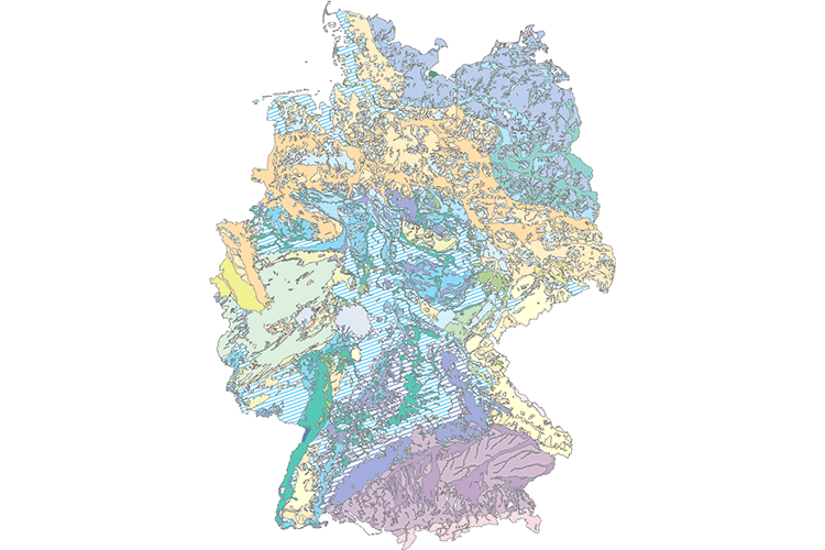
Geogenic Groundwater Quality of Germany 1:1,000,000 (GEOGW1000)
The map shows the representative chemical content of groundwater for 22 hydrogeological subregions of Germany. The classification of each sub-region was based on the TDS value (total dissolved solids) and the chemical inventory. According to the degree of mineralization, five classes of waters were distinguished (very small, low, medium, high and strongly changing solution contents). The classification of the waters by their chemical inventory was made according to the equivalent percentage of the main cations and anions based on the Piper quadruple diagram. With this chemical classification and the degree of mineralization, 22 geogenic groundwater types could be differentiated throughout Germany. The basis for the mapping of geogenic groundwater quality is the "Hydrogeological Regions" map. The water quality data comes from the groundwater monitoring networks of the German federal states, which were collected by the State Geological Surveys or the State Environmental Surveys. Further analyses are based on the data of the former Central Geological Institute (ZGI) of the GDR. In total, sample data of nearly 8,000 observation wells have been evaluated.
|
|
Citation proposal
(2019) . Geogenic Groundwater Quality of Germany 1:1,000,000 (GEOGW1000). https://gdk.gdi-de.org/geonetwork/srv/api/records/EC6DF478-52C4-4EE3-BEA4-787502D083BD |
Simple
- Alternate title
- GEOGW1000
- Date ( Publication )
- 2019-08-15
- Edition
- v1.0
- Identifier
- C85949D0-51F1-4CE7-A307-7328FCFFE46E
Author
Author
- Other citation details
- GEOGW1000 (c) BGR Hannover 2019
- Status
- completed Completed
Point of contact
- GEMET - INSPIRE themes, version 1.0 ( Theme )
-
- Geologie
- GEMET - Concepts, version 2.4 ( Theme )
-
- Grundwasser
- Hydrogeologie
- Keywords ( Theme )
-
- Geogene Grundwasserbeschaffenheit
- HAD
- HAD 5.7
- GEOGW
- HK1000
- Keywords ( Place )
-
- Deutschland
- Access constraints
- Other restrictions
- Use constraints
- Other restrictions
- Other constraints
- Allgemeine Geschäftsbedingungen, siehe https://www.bgr.bund.de/AGB - General terms and conditions, see https://www.bgr.bund.de/AGB_en. Die bereitgestellten Informationen sind bei Weiterverwendung wie folgt zu zitieren: Datenquelle: GEOGW1000 (c) BGR Hannover 2019
- Spatial representation type
- Vector
- Denominator
- 1000000
- Metadata language
- ger German
- Character set
- utf8 UTF8
- Topic category
-
- Geoscientific information
N
S
E
W
))
- Geographic identifier
- Regionalschlüssel / 000000000000
- Distribution format
-
- Shapefile (n/a )
- Transfer size
- 11
- OnLine resource
-
GEOGW1000 (Shapefile)
GEOGW1000 im Format ESRI Shape
- OnLine resource
-
Informationen zum Projekt HAD und Bezugsquelle der gedruckten Atlastafel - Information about the project and supply of the printed edition
Informationen zum Projekt HAD und Bezugsquelle der gedruckten Atlastafel - Information about the project and supply of the printed edition
- OnLine resource
-
Karte im BGR-Geoviewer
Karte im BGR-Geoviewer
- Hierarchy level
- Dataset
- Statement
- Grundlage für die Kartierung der geogenen Grundwasserbeschaffenheit ist die Karte "Hydrogeologische Regionen". Die Wasserbeschaffenheitsdaten stammen aus den Grundwassermessnetzen der deutschen Bundesländer, die von den Landesämtern für Geologie/Bodenforschung bzw. Umwelt erhoben wurden. Weitere Analysen gehen auf den Datenbestand des ehemaligen Zentralen Geologischen Instituts der DDR zurück. Insgesamt wurden Proben aus knapp 8000 Grundwassermessstellen ausgewertet.
gmd:MD_Metadata
- File identifier
- EC6DF478-52C4-4EE3-BEA4-787502D083BD XML
- Metadata language
- German
- Character set
- utf8 UTF8
- Hierarchy level
- dataset Dataset
- Hierarchy level name
- Grundwasser
- Date stamp
- 2023-08-21
- Metadata standard name
- INSPIRE Metadata Implementing Rules: Technical Guidelines based on EN ISO 19115 and EN ISO 19119
- Metadata standard version
- n/a
Point of contact
Overviews
Provided by

Views
EC6DF478-52C4-4EE3-BEA4-787502D083BD
Access to the portal
Read here the full details and access to the data.
Associated resources
Not available