 My GeoNetwork catalogue
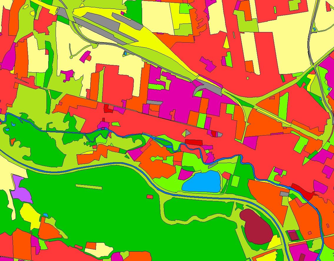
Landbedeckungsmodell für Deutschland (LBM-DE) 2018
Das Landbedeckungsmodell Deutschland (LBM-DE) besitzt eine detaillierten Gliederung in Landbedeckung (LB) und Landnutzung (LN) bei einer Mindestkartierfläche von 1ha. Aus den Kombinationen von LB und LN werden eindeutige CORINE LandCover-Klassen abgeleitet ("CLC").
Simple
- Alternate title
-
LBM-DE2018
- Date (Creation)
- 2017-08-28T00:00:00.000+02:00
- Date (Revision)
- 2020-10-01T00:00:00.000+02:00
- Citation identifier
- https://registry.gdi-de.org/id/de.bund.bkg.csw/63f83c30-6c18-4bfd-bb6c-81bb5780da9e
- Status
- Completed
+49 69 6333-251
https://www.bkg.bund.de
+49 69 6333-235
https://www.bkg.bund.de
- Maintenance and update frequency
- Continual
- Update scope
- Dataset
- Keywords
-
-
CLC
-
Landnutzung
-
-
GEMET - Concepts, version 3.1
- Use constraints
- Other restrictions
- Other constraints
-
Wenden Sie sich bitte an das Dienstleistungszentrum (DLZ) des Bundesamt für Kartographie und Geodäsie: https://www.bkg.bund.de/DE/Service/Kontakt/kontakt.html
- Other constraints
-
Quellenvermerk: © GeoBasis-DE / BKG (Jahr des letzten Datenbezugs)
- Access constraints
- License
- Access constraints
- Other restrictions
- Spatial representation type
- Grid
- Denominator
- 25000
- Language
- Deutsch
- Topic category
-
- Imagery base maps earth cover
- Extent type code
- Yes
- Geographic identifier
- Bundesrepublik Deutschland
))
- Begin date
- 2018-01-01T00:00:00.000+01:00
- End date
- 2018-12-31T00:00:00.000+01:00
- Unique resource identifier
- EPSG 4258: ETRS89 / geographisch
- Unique resource identifier
- EPSG 25833: ETRS89 / UTM Zone 33N
- Unique resource identifier
- EPSG 25832: ETRS89 / UTM Zone 32N
- Unique resource identifier
- EPSG 31469: DHDN / Gauss-Krüger Zone 5
- Unique resource identifier
- EPSG 31468: DHDN / Gauss-Krüger Zone 4
- Unique resource identifier
- EPSG 31467: DHDN / Gauss-Krüger Zone 3
- Distribution format
-
-
Shapefiles
()
-
Shapefiles
()
Distributor
+49 69 6333-251
https://www.bkg.bund.de
- OnLine resource
- Produktseite des Webshops des Geodatenzentrums
- OnLine resource
- Dienst "WMS Landbedeckungsmodell für Deutschland 2018" (GetCapabilities) ( OGC Web Map Service )
- Hierarchy level
- Dataset
Completeness omission
- Name of measure
-
Rate of missing items
- Measure identification
- 7
- Measure description
-
completeness omission (rec_grade)
Quantitative result
- Value
- 0
Absolute external positional accuracy
- Name of measure
-
Mean value of positional uncertainties (2D)
- Measure identification
- 28
- Measure description
-
geographic
Quantitative result
- Value
- 5
Conformance result
- Date (Publication)
- 2010-12-08
- Explanation
-
see the referenced specification
- Pass
- No
Completeness commission
- Name of measure
-
Number of duplicate feature instances
- Measure identification
- 4
Quantitative result
- Value
- 0
Completeness commission
- Name of measure
-
Rate of excess items
- Measure identification
- 3
Quantitative result
- Value
- 0
Conceptual consistency
- Name of measure
-
Number of invalid overlaps of surfaces
- Measure identification
- 11
Quantitative result
- Value
- 0
Conceptual consistency
- Name of measure
-
Compliance rate with the rules of the conceptual schema
Quantitative result
- Value
- 100
Domain consistency
- Name of measure
-
Value domain non conformance rate
- Measure identification
- 17
Quantitative result
- Value
- 0
Format consistency
- Name of measure
-
Physical structure conflict rate
- Measure identification
- 20
Quantitative result
- Value
- -1
Thematic classification correctness
- Name of measure
-
Misclassification rate
- Measure identification
- 61
Quantitative result
- Value
- 10
Quantitative attribute accuracy
- Name of measure
-
Attribute value uncertainty at 95 % significance level
- Measure identification
- 71
Quantitative result
- Value
- 5
- Statement
-
Das BKG erstellt und aktualisiert das LBM-DE, welches auf Geobasisdaten aufsetzt und Satellitenbilder zur Aktualisierung nutzt.
- Description
-
Aktualisierung des LBM-DE2015 mit Satellitenbilddaten (RapidEye), BasisDLM und DOP
- Description
-
RapidEye
- Description
-
DOP
- Description
-
BasisDLM
- File identifier
- ED7F6DE9-6433-41DA-928A-044837C6EDAA XML
- Metadata language
- Deutsch
- Character set
- UTF8
- Hierarchy level
- Dataset
- Date stamp
- 2026-05-05
- Metadata standard name
-
ISO19115
- Metadata standard version
-
2003/Cor.1:2006
Overviews
Spatial extent
Provided by
