 My GeoNetwork catalogue
Luftbilder 2001
Geflogen wurde der Süden Anfang April und der Norden Ende April 2001. Grenzlinie ca. 5621000
Bodenauflösung 10 cm
INSPIRE
Identification
- fileIdentifier
- FC28F7DA-31F2-4FF5-9EE2-3B827ACC85A4 XML
- hierarchyLevel
- Dataset
Online resource
Resource identifier
- language
- Deutsch
- spatialRepresentationType
- Grid
Encoding
- Format
-
TIF(TFW)
- Version
-
-
- Format
-
GeoTIF
- Version
-
-
- Format
-
JPG
- Version
-
-
- Format
-
GIF
- Version
-
-
Projection
Classification of data and services
- topicCategory
-
- Imagery base maps earth cover
Classification of data and services
Coupled resource
Coupled resource
Classification of data and services
Coupled resource
Coupled resource
Keywords
Other keywords
- Keywords
-
-
INTER|01 EINE Grundkarte wählen\Luftbilder\Luftbild 2001
-
Lufbilder
-
Luftbilder 2001
-
Orthophoto
-
Geographic coverage
N
S
E
W
))
Temporal reference
Temporal extent
Temporal extent
- date (Creation)
- 2009-12-15
- date (Revision)
- 2020-09-01
- date (Publication)
- 2009-12-15
Quality and validity
- Lineage
-
Vollständigkeit: vollständig
Genauigkeit: 10 - 50 cm
Aktualität: keine Pflege (2001)
- denominator
- 1000
Conformity
Conformity
Conformity
Conformity
Conformity
Conformity
- Explanation
-
INSPIRE "Interoperabilität von Geodatensätzen und -diensten"
- Explanation
-
INSPIRE Annex-Thema "Orthofotografie"
Restrictions on access and use
- Access constraints
-
Es gelten keine Zugriffsbeschränkungen
- Access constraints
-
Es gelten keine Zugriffsbeschränkungen
- Access constraints
-
Datensatz ist kostenpflichtig
- Access constraints
-
Nutzungsbedingung: Nur über schriftliche Nutzungsvereinbarung
Responsible organization (s)
Contact for the resource
- Organisation name
-
Stadt Zwickau
Responsible organization (s)
Contact for the resource
- Organisation name
-
Stadt Zwickau
Metadata information
Contact for the metadata
- Organisation name
-
Stadt Zwickau
- dateStamp
- 2022-05-19
- language
- Deutsch
- characterSet
- 8859 Part 1
SDS
Conformance class 1: invocable
Access Point URL
Endpoint URL
Technical specification
Conformance class 2: interoperable
Access constraints
Limitation
Use constraints
Limitation
Responsible custodian
Contact for the resource
Overviews
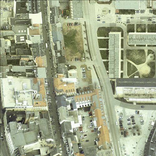
Beispiel Kartenausschnitt
Spatial extent
N
S
E
W
Provided by

Associated resources
Not available