 My GeoNetwork catalogue
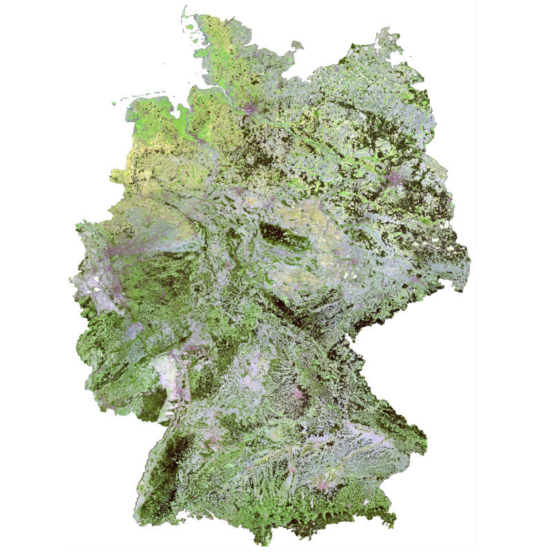
SCMaP - Landsat - Germany, 1984-2014
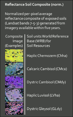
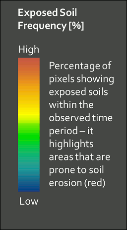
The Soil Composite Mapping Processor (SCMaP) is a new approach designed to make use of per-pixel compositing to overcome the issue of limited soil exposure due to vegetation. Three primary product levels are generated that will allow for a long term assessment and distribution of soils that include the distribution of exposed soils, a statistical information related to soil use and intensity and the generation of exposed soil reflectance image composites. The resulting composite maps provide useful value-added information on soils with the exposed soil reflectance composites showing high spatial coverage that correlate well with existing soil maps and the underlying geological structural regions.
Simple
- Date (Creation)
- 2018-11-17T00:00:00
- Citation identifier
- https://geoservice.dlr.de/catalogue/srv/metadata/a1543075-f6a6-47ac-b45c-cece50778dc0
- Presentation form
- Digital map
- Other citation details
-
DOI: 10.15489/c5ng9ynnyx29
- Status
- Completed
- Maintenance and update frequency
- As needed
-
GEMET - INSPIRE themes, version 1.0
-
-
Soil
-
- Keywords
-
-
Landsat
-
Soil mapping
-
Image composites
-
automated processors
-
top soil analysis
-
time series
-
SCMaP
-
Germany
-
- Use limitation
-
Nutzungseinschränkungen: The Soil Composite Images are provided without any warranty. DLR is not liable for damage resulting from use.
- Use limitation
-
Nutzungsbedingungen: License, https://creativecommons.org/licenses/by-nc-sa/4.0/
- Access constraints
- Other restrictions
- Other constraints
-
License
- Use constraints
- License
- Use constraints
- Other restrictions
- Other constraints
-
Nutzungsbedingungen: License, https://creativecommons.org/licenses/by-nc-sa/4.0/
- Other constraints
-
{"id": "other-open",
"name": "Andere offene Lizenz",
"url": " http://dcat-ap.de/def/licenses/other-open ",
"quelle": "Copyright DLR (year of production)"}
- Spatial representation type
- Grid
- Denominator
- 60000
- Language
-
eng
- Character set
- UTF8
- Topic category
-
- Geoscientific information
))
- Begin date
- 1984-04-13T00:00:00
- End date
- 2014-11-09T00:00:00
- Reference system identifier
- EPSG / WGS 84 (EPSG:4326) / 7.4
- Number of dimensions
- 2
- Dimension name
- Column
- Dimension size
- 39606
- Resolution
- 30 m
- Dimension name
- Row
- Dimension size
- 32406
- Resolution
- 30 m
- Cell geometry
- Area
- Transformation parameter availability
- No
- Distribution format
-
- OnLine resource
-
OPUS-GMES
(
WWW:LINK-1.0-http--link
)
OPUS-GMES Project Website
- OnLine resource
-
AGRO-DE
(
WWW:LINK-1.0-http--link
)
AGRO-DE Project Website
- OnLine resource
-
SCMAP_SN_LS
(
OGC:WMS
)
SCMaP Reflectance Soil Composite (normalized)
- OnLine resource
-
SCMAP_SN_LS_1984-2014
(
OGC:WMS
)
SCMaP Reflectance Soil Composite 1984-2014 (normalized)
- OnLine resource
-
SCMAP_SR_LS
(
OGC:WMS
)
SCMaP Reflectance Composite
- OnLine resource
-
SCMAP_SR_LS_1984-2014
(
OGC:WMS
)
SCMaP Reflectance Composite 1984-2014
- OnLine resource
-
SCMAP_SC_LS
(
OGC:WMS
)
SCMaP Exposed Soil Coverage
- OnLine resource
-
SCMAP_SC_LS_1984-2014
(
OGC:WMS
)
SCMaP Exposed Soil Coverage 1984-2014
- OnLine resource
-
SCMAP_SF_LS
(
OGC:WMS
)
SCMaP Exposed Soil Frequency
- OnLine resource
-
SCMAP_SF_LS_1984-2014
(
OGC:WMS
)
SCMaP Exposed Soil Frequency 1984-2014
- OnLine resource
- Legend "Reflectance Soil Composite" ( WWW:LINK-1.0-http--link )
- OnLine resource
- Legend "Exposed Soil Frequency" ( WWW:LINK-1.0-http--link )
- OnLine resource
- Legend "Reflectance Composite" ( WWW:LINK-1.0-http--link )
- OnLine resource
- Legend "Exposed Soil Cover" ( WWW:LINK-1.0-http--link )
- Hierarchy level
- Dataset
Domain consistency
- Measure identification
- INSPIRE / Conformity_001
Conformance result
- Date (Publication)
- 2010-12-08
- Explanation
-
See the referenced specification.
- Pass
- Yes
- Statement
-
Input data: Landsat 4, 5 and 7.
- Description
-
Generation of the soil composite maps comprises three different automated modules which include: 1) download and ingestion; 2) preprocessing and data filtering; and, 3) the SCMaP. While step 1 and 2 are part of the TimeScan framework (Esch et al., 2017 submitted), step three has been specifically developed for building soil composites. Crucial is the selection of pixels covering exposed soil from a multitemporal composite image that was built using a multispectral vegetation index and a threshold calibrated using broad land cover classes over Germany. In the result, several products have been developed: 1) useful value-added information on the spatial distribution and extend of exposed soils; 2) statistical information related to agricultural use and intensity (e.g. depending on cultivation cycle and pattern); and, 3) soil composite reflectance images of high spatial coverage that correlate well with existing soil and geological maps.
- Description
-
The accuracy depends on: 1) quality of data preprocessing (cloud masking, atmospheric correction), 2) threshold definition. For further information see Rogge et al. 2018: Rogge, D., Bauer, A., Zeidler, J., Mueller, A., Esch, T., Heiden, U. (2018). Building an exposed soil composite processor (SCMaP) for mapping spatial and temporal characteristics of soils with Landsat imagery (1984-2014). Remote Sensing of Environment, 205, 1-17. DOI: 10.1016/j.rse.2017.11.004 ISSN 0034-4257. https://www.sciencedirect.com/science/article/pii/S003442571730514X
- File identifier
- a1543075-f6a6-47ac-b45c-cece50778dc0 XML
- Metadata language
- English
- Character set
- UTF8
- Hierarchy level
- Dataset
- Hierarchy level name
-
Dataset
- Date stamp
- 2024-11-11T08:45:24
- Metadata standard name
-
19115-1:2014/19139
- Metadata standard version
-
1.0
Overviews
Spatial extent
Provided by
