 My GeoNetwork catalogue
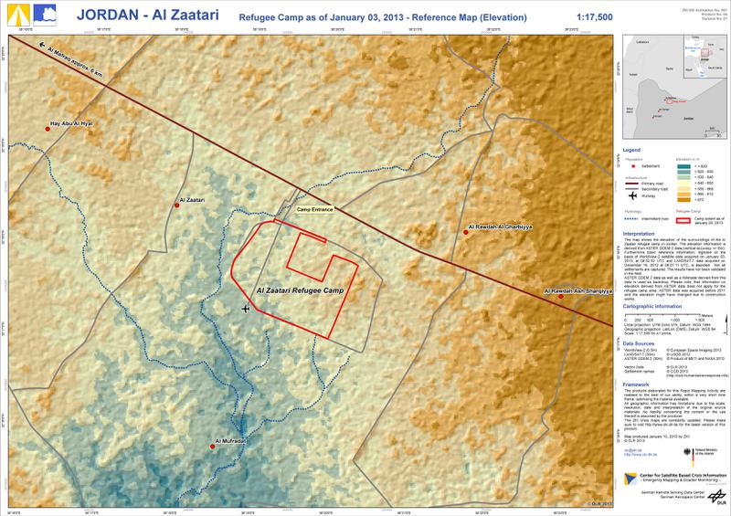
Jordan - Al Zaatari - P04 - Refugee Camp as of January 03, 2013 - Reference Map (Elevation)
The map shows the elevation of the surroundings of the Al Zaatari refugee camp in Jordan. The elevation information is derived from ASTER GDEM 2 data (vertical accuracy +/- 6m). Furthermore basic reference information, digitized on the basis of WorldView-2 satellite data acquired on January 03, 2013, at 08:52:52 UTC and LANDSAT-7 data acquired on December 16, 2012 at 08:07:11 UTC, is depicted. Not all settlements are captured. The results have not been validated in the field. ASTER GDEM 2 data as well as a hillshade derived from this data is used as backdrop. Please note, that information on elevation derived from ASTER data does not apply for the refugee camp area. ASTER data was acquired before 2011 and the elevation might have changed due to construction works. The products elaborated for this Rapid Mapping Activity are realised to the best of our ability, within a very short time frame, optimising the material available. All geographic information has limitations due to the scale, resolution, date and interpretation of the original source materials. No liability concerning the content or the use thereof is assumed by the producer. The ZKI crisis maps are constantly updated. Please make sure to visit http://www.zki.dlr.de for the latest version of this product.
Simple
- Date (Creation)
- 2013-01-10
- Citation identifier
- https://geoservice.dlr.de/catalogue/srv/metadata/a396c2b7-3b95-502b-9afb-dfc6bb151376
+49-(0)8153-28-1445
- Maintenance and update frequency
- As needed
-
GEMET - INSPIRE themes, version 1.0
-
-
Human health and safety
-
-
ZKI-DE Produktportfolio according to Annex 1 to the framework contract between BMI und DLR
-
-
Humanitarian Crisis
-
- Place
-
-
Jordan
-
Al Zataari
-
- Keywords
-
-
DLR
-
EOC
-
ZKI
-
- Use limitation
-
Product is optimized for Din A1 printing.
- Use limitation
-
The products elaborated for this Rapid Mapping Activity are realised to the best of our ability, within a very short time frame, during a crisis, optimising the material available. All geographic information has limitations due to the scale, resolution, date and interpretation of the original source materials. No liability concerning the content or the use thereof is assumed by the producer.
- Use constraints
- Other restrictions
- Other constraints
-
License, use limitations and references ( http://s.dlr.de/vz8 2) according to the framework contract between the German Federal Ministry of the Interior (BMI) and DLR for ZKI products.
- Access constraints
- Other restrictions
- Other constraints
-
no access restrictions
- Denominator
- 17500
- Distance
- 30 m
- Language
- English
- Character set
- UTF8
- Topic category
-
- Geoscientific information
))
- Reference system identifier
-
http://www.opengis.net/def/crs/EPSG/0/32637
EPSG Geodetic Parameter Dataset 2010-03-31 7.5 EPSG
- Distribution format
-
- OnLine resource
-
DLR-ZKI-DE_2013_001_Jordan_Flood_Geographic-Reference-Map_P04_V01_high.jpg
(
WWW:DOWNLOAD-1.0-http--download
)
Product in 300dpi resolution
- OnLine resource
-
DLR-ZKI-DE_2013_001_Jordan_Flood_Geographic-Reference-Map_P04_V01_med.jpg
(
WWW:DOWNLOAD-1.0-http--download
)
Product in 150dpi resolution
- OnLine resource
-
DLR-ZKI-DE_2013_001_Jordan_Flood_Geographic-Reference-Map_P04_V01_low.jpg
(
WWW:DOWNLOAD-1.0-http--download
)
Product in 100dpi resolution
- OnLine resource
-
DLR-ZKI-DE_2013_001_Jordan_Flood_Geographic-Reference-Map_P04_V01.pdf
(
WWW:DOWNLOAD-1.0-http--download
)
GeoPDF Product
- OnLine resource
-
DLR-ZKI-DE_2013_001_Jordan_Flood_Geographic-Reference-Map_P04_V01.kmz
(
WWW:DOWNLOAD-1.0-http--download
)
Product as KMZ in 100dpi resolution
- Hierarchy level
- Dataset
- Statement
-
Statement of conformity: The Center for Satellite Based Crisis Information (ZKI) produced this product by satellite analyses in the context of the framework contract between BMI and DLR. Quality Disclaimer: This product is a standard product in line with the ZKI-DE portfolio and/or with the mapping guidelines current at time of production. Data sources: WorldView-2 © European Space Imaging 2013; LANDSAT-7 © USGS 2012; ASTER GDEM 2 © Product of METI and NASA 2010
- Description
-
Vector data creation by manual interpretation and digitization of WorldView-2 data of January 03, 2013
- Description
-
Map compilation and cartographical enhancement
- Description
-
Product generation using ArcGIS 10.1, SP1, ZKI Export Tool 0.1
- File identifier
- a396c2b7-3b95-502b-9afb-dfc6bb151376 XML
- Metadata language
- English
- Character set
- UTF8
- Hierarchy level
- Dataset
- Date stamp
- 2024-06-20T13:13:08
- Metadata standard name
-
ISO 19115:2003/19139
- Metadata standard version
-
1.0
+49-(0)8153-28-1445
Overviews

Spatial extent
Provided by
