 My GeoNetwork catalogue
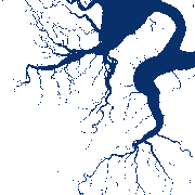
SWIM Water Extent - Sentinel-1/2 - Daily
SWIM Water Extent is a global surface water product at 10 m pixel spacing based on Sentinel-1/2 data. The collection contains binary layers indicating open surface water for each Sentinel-1/2 scene. Clouds and cloud shadows are removed using ukis-csmask (see: https://github.com/dlr-eoc/ukis-csmask ) and are represented as NoData. The water extent extraction is based on convolutional neural networks (CNN). For further information, please see the following publications: https://doi.org/10.1016/j.rse.2019.05.0 22 and https://doi.org/10.3390/rs11192330
- Identification
- Distribution
- Quality
- Spatial rep.
- Ref. system
- Content
- Portrayal
- Metadata
- Md. constraints
- Md. maintenance
- Schema info
Identification
Data identification
Citation
- Date (Creation)
- 2025-02-25T00:00:00
- Citation identifier
- https://geoservice.dlr.de/catalogue/srv/metadata/a9860b91-ef10-40d2-acaf-603336816d2a
- Presentation form
- Digital map
- Status
- On going
- Maintenance and update frequency
- As needed
-
GEMET - INSPIRE themes, version 1.0
-
-
Land cover
-
Hydrography
-
- Keywords
-
-
DLR
-
EOC
-
Sentinel-1
-
Sentinel-2
-
Global
-
water extent
-
SWIM
-
- Use limitation
-
Nutzungseinschränkungen: Das DLR ist nicht haftbar für Schäden, die sich aus der Nutzung ergeben. / Use Limitations: DLR not liable for damage resulting from use.
Legal constraints
- Access constraints
- Other restrictions
- Other constraints
- Es gelten keine Zugriffsbeschränkungen
Legal constraints
- Use constraints
- Other restrictions
- Other constraints
-
Nutzungsbedingungen: Lizenz, https://creativecommons.org/licenses/by-nc/4.0 / Terms of use: License, https://creativecommons.org/licenses/by-nc/4.0
- Other constraints
-
{"id": "cc-by-nc-4.0",
"name": "Creative Commons Namensnennung – 4.0 International (CC BY NC 4.0)",
"url": " http://dcat-ap.de/def/licenses/cc-by-nc/4.0 ",
"quelle": "Copyright DLR (year of production)"}
- Spatial representation type
- Grid
- Denominator
- 20000
- Language
- English
- Character set
- UTF8
- Topic category
-
- Imagery base maps earth cover
- Inland waters
Extent
))
- Begin date
- 2015-07-04T00:00:00
Distribution
Distribution
- Distribution format
-
-
GeoTIFF
()
-
GeoTIFF
()
Digital transfer options
- OnLine resource
-
Scientific publication
(
WWW:LINK-1.0-http--link
)
Scientific publication on Sentinel-1-Based Water and Flood Mapping
- OnLine resource
-
Scientific publication
(
WWW:LINK-1.0-http--link
)
Scientific publication on a modular processing chain for automated flood monitoring from multi-spectral satellite data
- OnLine resource
-
EOC Geoservice Map Context
(
WWW:LINK-1.0-http--link
)
EOC Geoservice Map Context (eoc:swim)
- OnLine resource
-
SWIM_WE
(
OGC:WMS
)
SWIM Water Extent
- OnLine resource
- https://geoservice.dlr.de/eoc/swim/wms?SERVICE=WMS&REQUEST=GetCapabilities ( OGC:WMS-http-get-capabilities )
- OnLine resource
-
EOC Download Service
(
WWW:LINK-1.0-http--link
)
EOC Download Service (SWIM Water Extent)
- OnLine resource
- EOC STAC Collection ( WWW:LINK-1.0-http--link )
Quality
Data quality
- Hierarchy level
- Series
Domain consistency
- Measure identification
- INSPIRE / Conformity_001
Conformance result
Citation
- Date (Publication)
- 2010-12-08
- Explanation
-
See the referenced specification.
- Pass
- Yes
Lineage
- Statement
-
The main input datasets are daily Sentinel-2 L2A and Sentinel-1 GRD at 10 m pixel spacing. The Copernicus GLO-30 DEM is included as an auxiliary dataset. For more information please refer to Wieland et. al (2019) (10.1016/j.rse.2019.05.022) and Bereczky et. al (2022) (10.1109/JSTARS.2022.3152127)
- Description
-
The water extent extraction is based on convolutional neural networks (CNN). For more information please refer to Wieland et. al (2019) (10.1016/j.rse.2019.05.022) and Bereczky et. al (2022) (10.1109/JSTARS.2022.3152127)
Ref. system
- Unique resource identifier
- EPSG:4326
Metadata
Metadata
- File identifier
- a9860b91-ef10-40d2-acaf-603336816d2a XML
- Metadata language
- English
- Character set
- UTF8
- Hierarchy level
- Series
- Hierarchy level name
-
Dataseries
- Date stamp
- 2025-05-21T12:00:39
- Metadata standard name
-
ISO 19115
- Metadata standard version
-
2003/Cor.1:2006
Overviews

Spatial extent
Provided by
