 My GeoNetwork catalogue
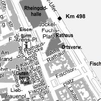
Stadtplan Mainz - Grau
Stadtplan Mainz (Farbe oder/und Grauwerte):
INSPIRE
Identification
- File identifier
- abd1ea03-c62d-62c6-cf3c-50b3fd4a855c XML
- Hierarchy level
- Service
Online resource
- Protocol
-
OGC:WMS-1.1.1-http-get-map
Resource identifier
Encoding
Projection
Classification of data and services
- Service Type
- view
- Coupling Type
- Loose
Coupled resource
Coupled resource
Classification of data and services
- Service Type
- view
- Coupling Type
- Loose
Coupled resource
Coupled resource
Keywords
-
mapbender.2.registryId
-
-
2f23ed6e-0186-4c2b-8380-748389036509
-
Other keywords
- Keywords
-
-
infoMapAccessService
-
Geographic coverage
))
Temporal reference
Temporal extent
Temporal extent
- Date (Revision)
- 2023-11-28
Conformity
Conformity
Conformity
Conformity
Conformity
Conformity
- Explanation
-
No explanation available
- Explanation
-
No explanation available
- Explanation
-
No explanation available
- Explanation
-
No explanation available
- Explanation
-
No explanation available
- Explanation
-
No explanation available
- Explanation
-
No explanation available
- Explanation
-
No explanation available
Restrictions on access and use
- Access constraints
- Es gelten keine Zugriffsbeschränkungen
- Access constraints
-
Lizenz: cc-by-nc-nd-3.0 - Creative Commons: Namensnennung - Keine kommerzielle Nutzung - Keine Bearbeitungen 3.0 Deutschland - http://creativecommons.org/licenses/by-nc-nd/3.0/de/
- Access constraints
-
{"id":"cc-by-nc-nd-3.0","name":"Creative Commons: Namensnennung - Keine kommerzielle Nutzung - Keine Bearbeitungen 3.0 Deutschland","url":"http:\/\/creativecommons.org\/licenses\/by-nc-nd\/3.0\/de\/"}
Responsible organization (s)
Contact for the resource
- Organisation name
-
60-Bauamt, Abt. Bodenmanagement und Geoinformation
Responsible organization (s)
Contact for the resource
- Organisation name
-
60-Bauamt, Abt. Bodenmanagement und Geoinformation
Metadata information
Contact for the metadata
- Organisation name
-
Stadt Mainz
- Date stamp
- 2026-04-26
- Metadata language
- Deutsch
SDS
Conformance class 1: invocable
- Pass
- Yes
- Pass
- Yes
- Pass
- Yes
- Pass
- Yes
- Pass
- Yes
- Pass
- Yes
- Pass
- Yes
- Pass
- Yes
Access Point URL
Endpoint URL
Technical specification
- Date
- Explanation
-
No explanation available
- Date
- Explanation
-
No explanation available
- Date
- Explanation
-
No explanation available
- Date
- Explanation
-
No explanation available
- Date
- Explanation
-
No explanation available
- Date
- Explanation
-
No explanation available
- Date
- Explanation
-
No explanation available
- Date
- Explanation
-
No explanation available
Conformance class 2: interoperable
Access constraints
- Access constraints
- Other restrictions
- Other constraints
- Es gelten keine Zugriffsbeschränkungen
Limitation
Use constraints
Limitation
- string
-
Lizenz: cc-by-nc-nd-3.0 - Creative Commons: Namensnennung - Keine kommerzielle Nutzung - Keine Bearbeitungen 3.0 Deutschland - http://creativecommons.org/licenses/by-nc-nd/3.0/de/
- string
-
{"id":"cc-by-nc-nd-3.0","name":"Creative Commons: Namensnennung - Keine kommerzielle Nutzung - Keine Bearbeitungen 3.0 Deutschland","url":"http:\/\/creativecommons.org\/licenses\/by-nc-nd\/3.0\/de\/"}
Responsible custodian
Contact for the resource
Conformance class 3: harmonized
Contains Operations
- Operation Name
-
GetCapabilities
- Distributed Computing Platforms
- Web services
Overviews
Spatial extent
Provided by
