 My GeoNetwork catalogue
Processed seismic data of Cruise M20/3 1992
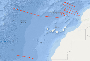
The METEOR cruise M20/3 from 4th February to 13th March 1992 had two scientific objectives: One research topic was to study the variability of the Mesozoic oceanic crust along two flow-line profiles located north of the Kane and Hayes Fracture Zones. The other research topic was the investigation of the weak magnetic anomalies in the Jurassic magnetic quiet zone north of the Canary Islands. Seismic data with a coverage of 2,400 % were acquired together with magnetic, gravimetric and hydroacoustic data along the two flow-line profiles with a total length of 1,595 km. Magnetic, gravimetric and hydroacoustic measurements were carried out on 31 profiles with a total length of 6,069 km in the Jurassic quiet zone north of the Canary Islands. On 10 of these lines multichannel seismic reflection data (2,138 km) have been acquired.
Simple
- Alternate title
-
M20/3 1992
- Date (Creation)
- 1992-03-13
- Citation identifier
- 204c76e3-30c9-3042-68f4-d2cfb24c430c
- Status
- Completed
-
GEMET - INSPIRE themes, version 1.0
-
-
Geologie
-
geology
-
-
GEMET - Concepts, version 2.4
-
-
geophysics
-
Geophysik
-
raw material
-
Rohstoff
-
- Theme
-
-
Marine geology
-
Meeresgeologie
-
Seismics
-
Seismik
-
Two-dimensional seismic reflection
-
zweidimensionale Reflektionsseismik
-
- Place
-
-
Central East Atlantic
-
Zentraler Ostatlantik
-
Canary Basin
-
Kanarenbecken
-
- Access constraints
- Other restrictions
- Other constraints
- Es gelten keine Zugriffsbeschränkungen
- Use constraints
- Other restrictions
- Other constraints
-
Allgemeine Geschäftsbedingungen, siehe http://www.bgr.bund.de/AGB - General terms and conditions, see http://www.bgr.bund.de/AGB_en . Die bereitgestellten Informationen sind bei Weiterverwendung wie folgt zu zitieren: Datenquelle: M20/3 1992, (c) BGR, Hannover, 1992
- Spatial representation type
- Vector
- Language
- English
- Character set
- UTF8
- Topic category
-
- Geoscientific information
))
- Unique resource identifier
- EPSG:4326
- Distribution format
-
-
Shapefile
(
n/a
)
-
Shapefile
(
n/a
)
- Transfer size
- 2
- OnLine resource
-
M20/3 1992 (Shapefile)
M20/3 1992 im Format ESRI Shape
- OnLine resource
- M203-011
- OnLine resource
- M203-012
- OnLine resource
- M203-013
- OnLine resource
- M203-014
- OnLine resource
- M203-015
- OnLine resource
- M203-016
- OnLine resource
- M203-024
- OnLine resource
- M203-025
- OnLine resource
- M203-026
- OnLine resource
- M203-027
- OnLine resource
- Karte im BGR-Geoviewer
- Hierarchy level
- Dataset
Conformance result
- Date (Publication)
- 2010-12-08
- Explanation
-
siehe dazu die angegebene Durchführungsbestimmung
- Statement
-
During the period from the 4th February to the 13th March 1992 BGR acquired seismic lines off West Africa in the Canary Basin. The lines M203-001, M203-002, M203-002A and M203-003 are raw data, the lines M203-011, M203-012, M203-013, M203-014, M203-015, M203-016, M203-024, M203-025, M203-026 and M203-027 are processed (migrated) data.
- File identifier
- ade3f819-ba37-45a3-b901-48510c6c33de XML
- Metadata language
- English
- Character set
- UTF8
- Parent identifier
-
Marine Seismic Survey Profiles (MSSP)
06a73c56-06a2-40d8-b806-466222b0760d
- Hierarchy level
- Dataset
- Hierarchy level name
-
Geophysik
- Date stamp
- 2023-11-14
- Metadata standard name
-
INSPIRE Metadata Implementing Rules: Technical Guidelines based on EN ISO 19115 and EN ISO 19119
- Metadata standard version
-
n/a
Overviews
Spatial extent
Provided by
