 My GeoNetwork catalogue
Processed seismic data of Cruise BGR99 1999
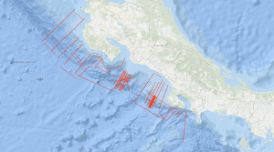
Between 08.11.1999 and 02.12.1999 the active convergent margin off Costa Rica was investigated using the S/V Professor Polshkov. The cruise had three scientific targets. Several seismic profiles in the dip-direction of the subduction zone were acquired to map the general variability of the accretionary wedge. Near the Jaco Scarp, a dense net of seismic profiles using a smaller seismic source should deliver information about the amount of gas hydrates within the shallow sub-surface. In an area of this wedge south of the Quepos Plateau densely spaced seismic lines were measured to prepare an ODP campaign (which was finished in 2011 as IODP Expedition 334).
Simple
- Alternate title
-
BGR99 1999
- Date (Creation)
- 1999-12-02
- Citation identifier
- 313ce6c8-1aed-1ea5-87c5-61c032a1c4bf
- Status
- Completed
-
GEMET - INSPIRE themes, version 1.0
-
-
Geologie
-
geology
-
-
GEMET - Concepts, version 2.4
-
-
geophysics
-
Geophysik
-
raw material
-
Rohstoff
-
- Theme
-
-
Marine geology
-
Meeresgeologie
-
Seismics
-
Seismik
-
Two-dimensional seismic reflection
-
zweidimensionale Reflektionsseismik
-
- Place
-
-
Northeast Pacific Ocean
-
Nordost-Pazifik
-
Costa Rica
-
- Access constraints
- Other restrictions
- Other constraints
- Es gelten keine Zugriffsbeschränkungen
- Use constraints
- Other restrictions
- Other constraints
-
Allgemeine Geschäftsbedingungen, siehe http://www.bgr.bund.de/AGB - General terms and conditions, see http://www.bgr.bund.de/AGB_en . Die bereitgestellten Informationen sind bei Weiterverwendung wie folgt zu zitieren: Datenquelle: BGR99 1999, (c) BGR, Hannover, 2018
- Spatial representation type
- Vector
- Language
- English
- Character set
- UTF8
- Topic category
-
- Geoscientific information
))
- Unique resource identifier
- EPSG:4326
- Distribution format
-
-
Shapefile
(
n/a
)
-
Shapefile
(
n/a
)
- Transfer size
- 2
- OnLine resource
-
BGR99 1999 (Shapefile)
BGR99 1999 im Format ESRI Shape
- OnLine resource
- Profile BGR99-01
- OnLine resource
- Profile BGR99-02
- OnLine resource
- Profile BGR99-03
- OnLine resource
- Profile BGR99-04
- OnLine resource
- Profile BGR99-05
- OnLine resource
- Profile BGR99-06
- OnLine resource
- Profile BGR99-07
- OnLine resource
- Profile BGR99-08
- OnLine resource
- Profile BGR99-09
- OnLine resource
- Profile BGR99-10
- OnLine resource
- Profile BGR99-11
- OnLine resource
- Profile BGR99-12
- OnLine resource
- Profile BGR99-12A
- OnLine resource
- Profile BGR99-13
- OnLine resource
- Profile BGR99-14
- OnLine resource
- Profile BGR99-15
- OnLine resource
- Profile BGR99-16
- OnLine resource
- Profile BGR99-16A
- OnLine resource
- Profile BGR99-17
- OnLine resource
- Profile BGR99-18
- OnLine resource
- Profile BGR99-19
- OnLine resource
- Profile BGR99-20
- OnLine resource
- Profile BGR99-21
- OnLine resource
- Profile BGR99-22
- OnLine resource
- Profile BGR99-23
- OnLine resource
- Profile BGR99-39
- OnLine resource
- Profile BGR99-40
- OnLine resource
- Profile BGR99-41
- OnLine resource
- Profile BGR99-42
- OnLine resource
- Profile BGR99-43
- OnLine resource
- Profile BGR99-44
- OnLine resource
- Profile BGR99-45
- OnLine resource
- Profile BGR99-46
- OnLine resource
- Profile BGR99-46A
- OnLine resource
- Profile BGR99-47
- OnLine resource
- Profile BGR99-47A
- OnLine resource
- Profile BGR99-48
- OnLine resource
- Profile BGR99-49A
- OnLine resource
- Profile BGR99-50
- OnLine resource
- Profile BGR99-51
- OnLine resource
- Profile BGR99-52
- OnLine resource
- Profile BGR99-53
- OnLine resource
- Profile BGR99-54
- OnLine resource
- Profile BGR99-55
- OnLine resource
- Profile BGR99-56
- OnLine resource
- Profile BGR99-57
- OnLine resource
- Profile BGR99-58
- OnLine resource
- Profile BGR99-58A
- OnLine resource
- Profile BGR99-59
- OnLine resource
- Profile BGR99-60
- OnLine resource
- Profile BGR99-61
- OnLine resource
- Profile BGR99-62
- OnLine resource
- Profile BGR99-63
- OnLine resource
- Profile BGR99-64
- OnLine resource
- Profile BGR99-65
- OnLine resource
- Profile BGR99-66
- OnLine resource
- Profile BGR99-67
- OnLine resource
- Profile BGR99-68
- OnLine resource
- Profile BGR99-69
- OnLine resource
- Karte im BGR-Geoviewer
- Hierarchy level
- Dataset
Conformance result
- Date (Publication)
- 2010-12-08
- Explanation
-
siehe dazu die angegebene Durchführungsbestimmung
- Statement
-
During the period from 8th November to 2nd December 1999 BGR acquired seismic lines off the Pacific coast of Costa Rica. All lines BGR99-01 to BGR99-23 and BGR99-39 to BGR99-69 consist of stacked data.
- File identifier
- b61ec9c1-0d1b-408f-8c13-aedb8a028b75 XML
- Metadata language
- English
- Character set
- UTF8
- Parent identifier
-
Marine Seismic Survey Profiles (MSSP)
06a73c56-06a2-40d8-b806-466222b0760d
- Hierarchy level
- Dataset
- Hierarchy level name
-
Geophysik
- Date stamp
- 2023-11-16
- Metadata standard name
-
INSPIRE Metadata Implementing Rules: Technical Guidelines based on EN ISO 19115 and EN ISO 19119
- Metadata standard version
-
n/a
Overviews
Spatial extent
Provided by
