 My GeoNetwork catalogue
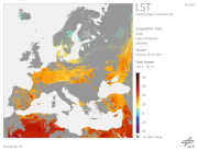
AVHRR - Land Surface Temperature (LST) - Europe, Daytime
The "Land Surface Temperature derived from NOAA-AVHRR data (LST_AVHRR)" is a fixed grid map (in stereographic projection ) with a spatial resolution of 1.1 km. The total size covering Europe is 4100 samples by 4300 lines. Within 24 hours of acquiring data from the satellite, day-time and night-time LSTs are calculated. In general, the products utilise data from all six of the passes that the satellite makes over Europe in each 24 hour period. For the daily day-time LST maps, the compositing criterion for the three day-time passes is maximum NDVI value and for daily night-time LST maps, the criterion is the maximum night-time LST value of the three night-time passes. Weekly and monthly day-time or night-time LST composite products are also produced by averaging daily day-time or daily night-time LST values, respectively. The range of LST values is scaled between –39.5°C and +87°C with a radiometric resolution of 0.5°C. A value of –40°C is used for water. Clouds are masked out as bad values. For additional information, please see: https://wdc.dlr.de/sensors/avhrr/
Simple
- Date (Creation)
- 2011-01-05T00:00:00
- Citation identifier
- https://geoservice.dlr.de/catalogue/srv/metadata/b673f41b-d934-49e4-af6b-44bbdf164367
- GEMET - INSPIRE themes, version 1.0
-
-
Land cover
-
- Keywords
-
-
NOAA-14
-
NOAA-16
-
NOAA-17
-
NOAA-18
-
NOAA-19
-
AVHRR
-
Land Surface Temperature (daytime)
-
Europe
-
urn:eop:DLR:EOWEB:NOAA.AVHRR.LST_D
-
FEDEO
-
- Use limitation
-
Nutzungseinschränkungen: Das DLR ist nicht haftbar für Schäden, die sich aus der Nutzung ergeben. / Use Limitations: DLR not liable for damage resulting from use.
- Use constraints
- Other restrictions
- Other constraints
-
License: https://geoservice.dlr.de/resources/licenses/D-SDA_DataLicenseTerms.pdf
- Language
- English
- Topic category
-
- Environment
))
- Begin date
- 1998-02-23T15:00:00
- Distribution format
-
- OnLine resource
-
AVHRR - Land Surface Temperature (LST) - Europe, Daytime
(
WWW:LINK-1.0-http--link
)
EOWEB GeoPortal Collection
- Hierarchy level
- Series
Domain consistency
- Measure identification
- INSPIRE / Conformity_001
Conformance result
- Date (Publication)
- 2010-12-08
- Explanation
-
See the referenced specification
- Pass
- Yes
- Statement
-
The LST maps are calculated using AVHRR channel 4 and 5, only. All LST products consist of one LST channel. The major processing steps are:
1. Automatic pre-navigation / Interactive supervision
2. Calibration of thermal channels of NOAA-11, NOAA-14, NOAA-16, NOAA-17 and NOAA-18 AVHRR
3. Cloud Screening and Clearing
3.1. Cloud detection scheme for DAY TIME LST from NOAA-14 AVHRR
3.2. Cloud detection scheme for DAY TIME LST from NOAA-16 AVHRR
4. Derivation of the LST
5. Remapping
Further information is available at http://wdc.dlr.de/sensors/avhrr/ and Dech, S., Tungalagsaikhan, P., Preusser, C., & Meisner, R., 1998. Operational value-adding to AVHRR data over Europe: methods, results, and prospects. Aerospace Science and Technology, 5, 335-346.
- File identifier
- b673f41b-d934-49e4-af6b-44bbdf164367 XML
- Metadata language
- English
- Character set
- UTF8
- Hierarchy level
- Series
- Hierarchy level name
-
Dataseries
- Date stamp
- 2024-09-27T12:48:48
- Metadata standard name
-
19115-1:2014/19139
- Metadata standard version
-
1.0
Overviews
Spatial extent
Provided by
