 My GeoNetwork catalogue
Processed seismic data of Cruise SO267 ARCHIMEDES I 2018
The cruise SO267 ARCHIMEDES I started on December 11th, 2018 in Suva (Fidji) and ended in Suva on January 26th, 2019. Over half of the world´s presently exploited metal deposits were formed during major episodes of crustal growth related to subduction and microplate tectonics. These processes are observed today along the entire margin of the Western Pacific, where complex microplate mosaics offer unique opportunities to study accretion and the emergence of new continental crust. The focus of SO267 was a series of crustal cross-sections at the outer edge of the Indo- Australian Plate, in the largely uncharted waters of the Kingdom of Tonga. The project, entitled “Arc Rifting, Metallogeny and Microplate Evolution – An Integrated Geodynamic, Magmatic and Hydrothermal Study of the Fonualei Rift System”, was designed to document the geological evolution of an emerging microplate mosaic in the NE Lau Basin, a region with some of the fastest growing crust on Earth, and to better understand the sequence of events that cause arc rifting and related magmatic-hydrothermal activity. Using a coordinated approach of high-resolution 2D seismics, electromagnetics and sampling, ARCHIMEDES I imaged the deep structure of the Fonualei Rift system and adjoining back-arc crust of the Niuafo’ou microplate. The goal was to address a major unsolved question concerning crustal growth in complex arc-backarc systems: at what stage in the structural and thermal evolution of the crust does arc rifting occur and seafloor spreading initiate? Planned operations included large-scale reflection and refraction seismic surveys, and a dense program of gravity, magnetics, heat flow, bathymetric mapping and sidescan imaging using the AUV ABYSS and ship-based multibeam systems. This ambitious program was made possible by a close collaboration between GEOMAR and BGR scientists, bringing together diverse expertise and state-of-the-art technologies. To understand the large-scale tectonic processes, we studied 6 different locations within an area of 300 km x 300 km: i) the southern Fonualei Rift Spreading Center (S-FRSC), ii) the region between the S-FRSC and the Eastern Lau Spreading Center (FRSC-ELSC Transfer Zone), iii) the northern tip of the Eastern Lau Spreading Center (ELSC), iv) the northern tip of the Fonualei Rift system (N-FRSC), v) the Mangatolu Triple Junction (MTJ), and vi) the southward propagating Northeast Lau Spreading centre (NELSC). The combined data represent one of the most comprehensive records of microplate formation from the modern oceans.
INSPIRE
Identification
- File identifier
- b8466d2b-d872-4f2b-acae-7be513628051 XML
- Hierarchy level
- Dataset
Online resource
Resource identifier
- code
-
f12ee0bb-2e87-d6c7-639f-4d04419122f3
- Metadata language
- English
Encoding
- Format
-
Shapefile
- Version
-
n/a
Projection
- code
- EPSG:4326
Classification of data and services
- Topic category
-
- Geoscientific information
Classification of data and services
Coupled resource
Coupled resource
Classification of data and services
Coupled resource
Coupled resource
Keywords
-
GEMET - INSPIRE themes, version 1.0
-
-
Geologie
-
geology
-
-
GEMET - Concepts, version 2.4
-
-
geophysics
-
Geophysik
-
raw material
-
Rohstoff
-
Other keywords
- Theme
-
-
Marine geology
-
Meeresgeologie
-
Seismics
-
Seismik
-
Two-dimensional seismic reflection
-
zweidimensionale Reflektionsseismik
-
- Place
-
-
Lau Basin
-
Lau-Becken
-
Tonga
-
Fidji
-
Geographic coverage
))
Temporal reference
Temporal extent
Temporal extent
- Date (Publication)
- 2019-01-26
Quality and validity
- Lineage
-
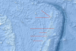
During the period from the 11th of December 2018 to the 26th of January 2019 BGR acquired seismic lines in the Lau Basin between Fidji and Tonga Islands. The lines BGR18-201 to BGR18-206 consist of migrated data.
Conformity
Conformity
Conformity
Conformity
Conformity
Conformity
- Explanation
-
siehe dazu die angegebene Durchführungsbestimmung
Restrictions on access and use
- Access constraints
- Es gelten keine Zugriffsbeschränkungen
- Access constraints
-
Allgemeine Geschäftsbedingungen, siehe https://www.bgr.bund.de/AGB - General terms and conditions, see https://www.bgr.bund.de/AGB_en . Die bereitgestellten Informationen sind bei Weiterverwendung wie folgt zu zitieren: Datenquelle: SO267 ARCHIMEDES I 2018, (c) BGR, Hannover, 2021
Responsible organization (s)
Contact for the resource
- Organisation name
-
Federal Institute for Geosciences and Natural Resources
Responsible organization (s)
Contact for the resource
- Organisation name
-
Federal Institute for Geosciences and Natural Resources
Metadata information
Contact for the metadata
- Organisation name
-
Bundesanstalt für Geowissenschaften und Rohstoffe (BGR)
- Date stamp
- 2023-11-16
- Metadata language
- English
- Character set
- UTF8
SDS
Conformance class 1: invocable
Access Point URL
Endpoint URL
Technical specification
Conformance class 2: interoperable
Access constraints
Limitation
Use constraints
Limitation
Responsible custodian
Contact for the resource
Overviews
Spatial extent
Provided by
