 My GeoNetwork catalogue
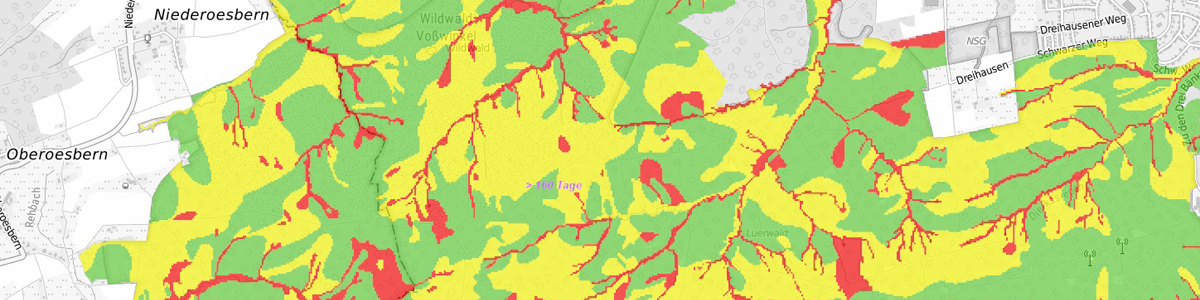
IS FSK 5 RCP8.5 Forstliche Standortkarte 1 : 5.000 von NRW, auf Grundlage der Bodenkarte 1 : 5.000 und Klimaprojektionen nach Szenario RCP8.5 - WMS
Der WMS zeigt die Standorteigenschaften für Waldstandorte in NRW im Maßstab 1 : 5.000 auf Basis von Projektionsdaten nach Klimaszenario RCP8.5 für den Zeitraum 2071-2100. Es werden der Gesamtwasserhaushalt und die natürliche Nährstoffversorgung der Standorte dargestellt. Abgeleitet vom Gesamtwasserhaushalt wird die Dürreempfindlichkeit der Waldstandorte dargestellt. In weiteren Layern werden die Standorteigenschaften aggregiert zu Standorttypen nach Waldbaukonzept NRW sowie die Standorteignung von 16 wichtigen Waldbaumarten nach den Kriterien des Waldbaukonzeptes NRW dargestellt. Die Auskunftsseite stellt die Eigenschaften für jede Fläche dar und bietet Verknüpfungen zu den Informationen des Waldbaukonzeptes NRW. Es handelt sich um eine Auswertung der Bodenkarte von NRW 1 : 5.000 in Verbindung mit Klimaprojektionsdaten für NRW für das Szenario RCP8.5 des Deutschen Wetterdienstes (2071-2100, DWD) und Reliefdaten (DGM10, Geobasis NRW). Es werden alle Bodenflächen dargestellt, von denen zum Zeitpunkt der Bereitstellung eine digitale Bodenkarte zur Forstlichen Standorterkundung - BK5 F - vorliegt.
INSPIRE
Identification
- File identifier
- b94299d3-4e13-4389-a10f-e5b65cd35298 XML
- Hierarchy level
- Service
Online resource
Resource identifier
Encoding
Projection
- code
- EPSG:4258
- code
- EPSG:4326
- code
- EPSG:25832
- code
- EPSG:3034
- code
- EPSG:3035
- code
- EPSG:3043
- code
- EPSG:3044
- code
- EPSG:3045
- code
- EPSG:3857
- code
- EPSG:4258
- code
- EPSG:4647
- code
- EPSG:5649
- code
- EPSG:5650
- code
- EPSG:5651
- code
- EPSG:5652
- code
- EPSG:5653
- code
- EPSG:25831
- code
- EPSG:25833
- code
- EPSG:31466
- code
- EPSG:31462
- code
- EPSG:31467
- code
- EPSG:31463
Classification of data and services
- Service Type
- view
- Coupling Type
- Tight
Coupled resource
Coupled resource
Classification of data and services
- Service Type
- view
- Coupling Type
- Tight
Coupled resource
Coupled resource
Keywords
-
OGDD-Kategorien
-
-
geo
-
Other keywords
- Discipline
-
-
Boden
-
Soil
-
Bodenkarte
-
Bodenkartierung
-
Bodenkunde
-
1 : 5 000
-
Bodeninformationssystem
-
Wald
-
Forst
-
Standort
-
Wasserhaushalt
-
Gesamtwasserhaushalt
-
Nährstoffversorgung
-
Nährstoffhaushalt
-
Forstliche Standortkarte
-
Baumarteneignung
-
Dürreempfindlichkeit
-
Waldentwicklungstypen
-
Waldbaukonzept NRW
-
Klimawandel
-
RCP8.5
-
Geographic coverage
))
Temporal reference
Temporal extent
Temporal extent
- Date (Publication)
- 2021-03-23
- Date (Revision)
- 2025-09-12
Conformity
Conformity
Conformity
Conformity
Conformity
Conformity
Restrictions on access and use
- Access constraints
- Es gelten keine Zugriffsbeschränkungen
- Access constraints
- Es gelten keine Bedingungen
Responsible organization (s)
Contact for the resource
- Organisation name
-
Geologischer Dienst NRW
Responsible organization (s)
Contact for the resource
- Organisation name
-
Geologischer Dienst NRW
Metadata information
Contact for the metadata
- Organisation name
-
Geologischer Dienst NRW
- Date stamp
- 2025-09-29
- Metadata language
- Deutsch
SDS
Conformance class 1: invocable
Access Point URL
Endpoint URL
Technical specification
Conformance class 2: interoperable
Access constraints
- Access constraints
- Other restrictions
- Other constraints
- Es gelten keine Zugriffsbeschränkungen
Limitation
Use constraints
- Use constraints
- Other restrictions
- Other constraints
- Es gelten keine Bedingungen
Limitation
Responsible custodian
Contact for the resource
Conformance class 3: harmonized
Contains Operations
- Operation Name
-
GetCapabilities
- Distributed Computing Platforms
- HTTPGet
- Connect Point
- https://www.wms.nrw.de/gd/fsk05_rcp85
Contains Operations
- Operation Name
-
GetMap
- Distributed Computing Platforms
- HTTPGet
- Connect Point
- https://www.wms.nrw.de/gd/fsk05_rcp85
Contains Operations
- Operation Name
-
GetFeatureInfo
- Distributed Computing Platforms
- HTTPGet
- Connect Point
- https://www.wms.nrw.de/gd/fsk05_rcp85
Contains Operations
- Operation Name
-
esri_wms:GetStyles
- Distributed Computing Platforms
- HTTPGet
- Connect Point
- https://www.wms.nrw.de/gd/fsk05_rcp85
Overviews
Spatial extent
Provided by
