 www.geodatenkatalog.de (S3L)
Processed seismic data of Cruise SO16 1981
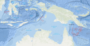
The results of the 1978 SONNE survey by the Federal Institute for Geosciences and Natural Resources (BGR), in the Coral Sea indicated the presence of narrow rift valleys beneath the outer margins of the Queensland and Papuan Plateaus. On the margins of these valleys, features were observed which were then interpreted to be large fossil reefs underlying an Eocene/Oligocene unconformity. These conclusions were important because they indicated that the Coral Sea Basin region is ideal for research into the fundamental problems concerning the development of continental margins. That is, the region offers similar problems to areas of the world where detailed studies are currently being conducted (e.g. West African margin) but with less complicated superimposed structure and a much thinner sediment cover. During the period from 29th November 1980 to 9th January 1981 a 'follow up' survey on the first and second leg of cruise SO-16 using the R/V SONNE was carried out in the northern Coral Sea, around the margins of the Coral Sea Basin, by the BGR in co-operation with the Bureau of Mineral Resources, Geology and Geophysics, Canberra (BMR) and the Geological Survey of Papua New Guinea, Port Moresby (GSPNG). The survey, which was divided into a geophysical cruise (first leg of SO-16) and a geological sampling cruise (second leg of SO-16), resulted in the recording of about 7,140 km of bathymetric and gravimetric data, of about 6,950 km of magnetic data, 3,150 km of digital multichannel seismic reflection profiles, 3,560 km of analogue single channel seismic reflection profiles, 10 sonobuoy refraction profiles and the sampling of 16 stations by dredging and 9 by coring. In the period from 9th January to 6th February 1981, geophysical investigations on the 3rd leg of SONNE cruise SO-16 were carried out in the Arafura Sea between Tanimbar, Aru and Kai Islands, and in the southern part of the Makassar Strait by BGR in co-operation with the Geological Research and Development Centre, Dept. Mines and Energy of Indonesia, Bandung and the Indonesian lnstitute of Sciences (LIPI), Bandung. 4,060 km of bathymetric and gravity lines, 3,080 km of magnetic lines, 1,415 km of reflection seismic lines (digital and analogue), and 9 sonobuoy profiles were recorded during this leg. Objectives of the Arafura Sea survey were determination of (a) thickness, seismic pattern, tectonic style and subsidence of the Cenozoic/Mesozoic depositional sequences at the transition from the Australian continental shelf to the Tanimbar outer arc ridge and (b) the configuration of the Precambrian rocks of the above mentioned transition zone. Objectives of the Makassar Strait survey were determination of (a) the nature and configuration of the acoustic basement underlying the South Makassar Basin, (b) the formation and nature of the sediments overlying the acoustic basement, (c) the regional distribution of a major unconformity of assumed Middle Miocene age as observed on profile VA16-24 of the VALDIVIA cruise VA-16 in 1977 in order to get a better understanding of the development of the South Makassar Basin.
|
|
Citation proposal
. Processed seismic data of Cruise SO16 1981. https://gdk.gdi-de.org/geonetwork/srv/api/records/c0e0434b-1a2f-4d05-8fee-6ee1cf8bc5ba |
Simple
- Alternate title
- SO16 1981
- Date ( Creation )
- 1981-02-06
- Identifier
- d9d72d29-09eb-be40-8518-1b75b8c16165
- Status
- completed Completed
Point of contact
- GEMET - INSPIRE themes, version 1.0 ( Theme )
-
- Geologie
- geology
- GEMET - Concepts, version 2.4 ( Theme )
-
- geophysics
- Geophysik
- raw material
- Rohstoff
- Keywords ( Theme )
-
- Marine geology
- Meeresgeologie
- Seismics
- Seismik
- Two-dimensional seismic reflection
- zweidimensionale Reflektionsseismik
- Keywords ( Place )
-
- Coral Sea
- Korallenmeer
- Arafura Sea
- Arafurasee
- Makassar Strait
- Makassar-Straße
- Access constraints
- Other restrictions
- Use constraints
- Other restrictions
- Other constraints
- Allgemeine Geschäftsbedingungen, siehe http://www.bgr.bund.de/AGB - General terms and conditions, see http://www.bgr.bund.de/AGB_en. Die bereitgestellten Informationen sind bei Weiterverwendung wie folgt zu zitieren: Datenquelle: SO16 1981, (c) BGR, Hannover, 2019
- Spatial representation type
- Vector
- Metadata language
- English
- Character set
- UTF8
- Topic category
-
- Geoscientific information
N
S
E
W
))
- Distribution format
-
- Shapefile (n/a )
- Transfer size
- 2
- OnLine resource
-
SO16 1981 (Shapefile)
SO16 1981 im Format ESRI Shape
- OnLine resource
-
Profile SO16-03
Profile SO16-03
- OnLine resource
-
Profile SO16-04
Profile SO16-04
- OnLine resource
-
Profile SO16-05
Profile SO16-05
- OnLine resource
-
Profile SO16-06
Profile SO16-06
- OnLine resource
-
Profile SO16-07
Profile SO16-07
- OnLine resource
-
Profile SO16-08
Profile SO16-08
- OnLine resource
-
Profile SO16-09
Profile SO16-09
- OnLine resource
-
Profile SO16-10
Profile SO16-10
- OnLine resource
-
Profile SO16-11
Profile SO16-11
- OnLine resource
-
Profile SO16-12
Profile SO16-12
- OnLine resource
-
Profile SO16-12A
Profile SO16-12A
- OnLine resource
-
Profile SO16-13
Profile SO16-13
- OnLine resource
-
Profile SO16-14
Profile SO16-14
- OnLine resource
-
Profile SO16-15
Profile SO16-15
- OnLine resource
-
Profile SO16-16
Profile SO16-16
- OnLine resource
-
Profile SO16-17
Profile SO16-17
- OnLine resource
-
Profile SO16-17A
Profile SO16-17A
- OnLine resource
-
Profile SO16-18
Profile SO16-18
- OnLine resource
-
Profile SO16-19
Profile SO16-19
- OnLine resource
-
Profile SO16-20
Profile SO16-20
- OnLine resource
-
Profile SO16-21
Profile SO16-21
- OnLine resource
-
Profile SO16-23
Profile SO16-23
- OnLine resource
-
Profile SO16-25
Profile SO16-25
- OnLine resource
-
Profile SO16-26
Profile SO16-26
- OnLine resource
-
Profile SO16-27
Profile SO16-27
- OnLine resource
-
Profile SO16-28
Profile SO16-28
- OnLine resource
-
Profile SO16-29
Profile SO16-29
- OnLine resource
-
Profile SO16-30
Profile SO16-30
- OnLine resource
-
Profile SO16-88
Profile SO16-88
- OnLine resource
-
Profile SO16-89
Profile SO16-89
- OnLine resource
-
Profile SO16-90
Profile SO16-90
- OnLine resource
-
Profile SO16-91
Profile SO16-91
- OnLine resource
-
Profile SO16-92
Profile SO16-92
- OnLine resource
-
Profile SO16-93
Profile SO16-93
- OnLine resource
-
Profile SO16-95
Profile SO16-95
- OnLine resource
-
Profile SO16-96
Profile SO16-96
- OnLine resource
-
Profile SO16-97
Profile SO16-97
- OnLine resource
-
Profile SO16-98
Profile SO16-98
- OnLine resource
-
Karte im BGR-Geoviewer
Karte im BGR-Geoviewer
- Hierarchy level
- Dataset
Conformance result
- Date ( Publication )
- 2010-12-08
- Explanation
- siehe dazu die angegebene Durchführungsbestimmung
- Statement
- During the period from 22nd November 1980 to 6th February 1981 BGR acquired seismic lines in the Coral Sea between Queensland (Australia) and Papua New Guinea, in the Arafura Sea and in the southern part of the Makassar Strait (Indonesia) during the legs 1, 2 and 3 of cruise SO16. The lines SO16-22 and SO16-24 consist of raw data. The lines SO16-11, SO16-17, SO16-17A, SO16-18, SO16-19, SO16-20, SO16-21, SO16-23, SO16-27, SO16-29, SO16-30, SO16-89, SO16-90, SO16-93, SO16-95, SO16-96, SO16-97 and SO16-98 are stacked data. The lines SO16-03, SO16-04, SO16-05, SO16-06, SO16-07, SO16-08, SO16-09, SO16-10, SO16-12, SO16-12A, SO16-13, SO16-14, SO16-15, SO16-16, SO16-25, SO16-26, SO16-28, SO16-88, SO16-91 and SO16-92 are migrated data.
gmd:MD_Metadata
- File identifier
- c0e0434b-1a2f-4d05-8fee-6ee1cf8bc5ba XML
- Metadata language
- English
- Character set
- UTF8
- Parent identifier
- 06a73c56-06a2-40d8-b806-466222b0760d
- Hierarchy level
- Dataset
- Hierarchy level name
- Geophysik
- Date stamp
- 2023-11-16
- Metadata standard name
- INSPIRE Metadata Implementing Rules: Technical Guidelines based on EN ISO 19115 and EN ISO 19119
- Metadata standard version
- n/a
Point of contact
Overviews
Provided by

Views
c0e0434b-1a2f-4d05-8fee-6ee1cf8bc5ba
Access to the portal
Read here the full details and access to the data.
Associated resources
Not available