 My GeoNetwork catalogue
Straßenverzeichnis Stadt Bochum
Das Straßenverzeichnis enthält neben den Hausnummernbereichen verschiedene statistische Einteilungen.
INSPIRE
Identification
- File identifier
- c294915f-59a9-40f8-9a08-c72eca7524d9 XML
- Hierarchy level
- Dataset
Online resource
- Protocol
-
WWW:LINK-1.0-http--link
Resource identifier
- Metadata language
- Deutsch
- Spatial representation type
- Text, table
Encoding
- Format
-
PDF
- Version
-
1.4
Projection
Classification of data and services
- Topic category
-
- Planning cadastre
Classification of data and services
Coupled resource
Coupled resource
Classification of data and services
Coupled resource
Coupled resource
Keywords
-
GEMET - INSPIRE themes, version 1.0
-
-
Statistische Einheiten
-
Adressen
-
-
GovData
-
-
Infrastruktur, Bauen und Wohnen
-
Politik und Wahlen
-
-
Region
-
-
Nordrhein-Westfalen
-
Regionalverband Ruhr
-
Bochum
-
Regierungsbezirk Arnsberg
-
Other keywords
- Theme
-
-
Straßenverzeichnis
-
Straße und Hausnummer
-
Straßenname
-
Gemarkung
-
Postleitzahl
-
Statistischer Bezirk
-
Statistisches Viertel
-
Stimmbezirk
-
Wahlbezirk
-
Finanzamtsbezirk
-
Geographic coverage
N
S
E
W
))
Temporal reference
Temporal extent
Temporal extent
- Date (Revision)
- 2017-02-17
Conformity
Conformity
Conformity
Conformity
Conformity
Conformity
Responsible organization (s)
Contact for the resource
- Organisation name
-
Stadt Bochum
Responsible organization (s)
Contact for the resource
- Organisation name
-
Stadt Bochum
Metadata information
Contact for the metadata
- Organisation name
-
Amt für Geoinformation, Liegenschaften und Kataster
- Date stamp
- 2024-04-30T13:27:17
- Metadata language
- Deutsch
- Character set
- UTF8
SDS
Conformance class 1: invocable
Access Point URL
Endpoint URL
Technical specification
Conformance class 2: interoperable
Access constraints
Limitation
Use constraints
Limitation
Responsible custodian
Contact for the resource
Overviews
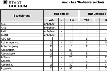
Straßenverzeichnis
Spatial extent
N
S
E
W
Provided by

Associated resources
Not available