 My GeoNetwork catalogue
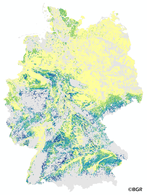
Amount of direct runoff on agricultural soils in Germany (WMS)
The map of the direct runoff on agricultural soils gives an overview of the average annual amount of precipitation, which does not infiltrate into the soils. It is based on pedological, relief and climatic factors. The map was created by using the empirical SCS – runoff curve number approach. The method was adapted by the Federal Institute for Geosciences and Natural Resources (BGR) as part of the attempt to model the seepage volume in the TUB_BGR method. The land use stratified soil map of Germany at scale 1:1,000,000 was used as pedological input to the model. The relief data was derived from the DEM50 of the BKG. The mean annual precipitation data of the period 1961 -1990 (DWD) is used as an input as well. The land use information is derived from CORINE Land Cover data set (2006).
INSPIRE
Identification
- File identifier
- c490b8eb-3ac4-4254-8af5-f99c9c17383f XML
- Hierarchy level
- Service
Online resource
Resource identifier
Encoding
- Format
-
png
- Version
-
n/a
- Format
-
jpeg
- Version
-
n/a
- Format
-
gif
- Version
-
n/a
Projection
- code
- EPSG:3034
Classification of data and services
- Service Type
- view
- Coupling Type
- Tight
Coupled resource
Coupled resource
Classification of data and services
- Service Type
- view
- Coupling Type
- Tight
Coupled resource
Coupled resource
Keywords
-
GEMET - INSPIRE themes, version 1.0
-
-
Boden
-
Soil
-
-
GEMET - Concepts, version 2.4
-
-
Oberflächenabfluss
-
Abfluss
-
Bodenwasserhaushalt
-
Ackerland
-
Other keywords
- Theme
-
-
Curve-Number
-
infoMapAccessService
-
- Place
-
-
Bundesrepublik Deutschland
-
Geographic coverage
))
Temporal reference
Temporal extent
Temporal extent
- Date (Publication)
- 2015-11-26
Quality and validity
- Lineage
-
Bodendaten aus BÜK1000N V2.31 (BGR), Landnutzungsdaten aus Corine Land Cover 2006 (UBA/DLR), Klimadaten des Deutschen Wetterdienstes, hier mittlerer jährlicher Niederschlag der Referenzperiode 1961-1990 (DWD) Reliefinformationen aus dem DGM50 des Bundesamtes für Kartographie und Geodäsie (BKG).
Conformity
Conformity
Conformity
Conformity
Conformity
Conformity
Restrictions on access and use
- Access constraints
- Es gelten keine Zugriffsbeschränkungen
- Access constraints
-
Allgemeine Geschäftsbedingungen, siehe https://www.bgr.bund.de/AGB - General terms and conditions, see https://www.bgr.bund.de/AGB_en . Die bereitgestellten Informationen sind bei Weiterverwendung wie folgt zu zitieren: Datenquelle: OAAcker1000_250 V1.0, (c) BGR, Hannover, 2015.
Responsible organization (s)
Contact for the resource
- Organisation name
-
Bundesanstalt für Geowissenschaften und Rohstoffe (BGR)
- Organisation name
-
Bundesanstalt für Geowissenschaften und Rohstoffe (BGR)
Responsible organization (s)
Contact for the resource
- Organisation name
-
Bundesanstalt für Geowissenschaften und Rohstoffe (BGR)
- Organisation name
-
Bundesanstalt für Geowissenschaften und Rohstoffe (BGR)
Metadata information
Contact for the metadata
- Organisation name
-
Bundesanstalt für Geowissenschaften und Rohstoffe (BGR)
- Date stamp
- 2024-01-24
- Metadata language
- Deutsch
SDS
Conformance class 1: invocable
Access Point URL
Endpoint URL
Technical specification
- Date
- Explanation
-
siehe dazu die angegebene Durchführungsbestimmung
Conformance class 2: interoperable
Access constraints
- Access constraints
- Other restrictions
- Other constraints
- Es gelten keine Zugriffsbeschränkungen
Limitation
Use constraints
Limitation
- string
-
Allgemeine Geschäftsbedingungen, siehe https://www.bgr.bund.de/AGB - General terms and conditions, see https://www.bgr.bund.de/AGB_en . Die bereitgestellten Informationen sind bei Weiterverwendung wie folgt zu zitieren: Datenquelle: OAAcker1000_250 V1.0, (c) BGR, Hannover, 2015.
Responsible custodian
Contact for the resource
- Organisation name
-
Bundesanstalt für Geowissenschaften und Rohstoffe (BGR)
Conformance class 3: harmonized
Contains Operations
- Operation Name
-
GetCapabilities
- Distributed Computing Platforms
- Web services
- Connect Point
- https://services.bgr.de/wms/boden/oaacker1000/?
Contains Operations
- Operation Name
-
GetMap
- Distributed Computing Platforms
- Web services
- Connect Point
- https://services.bgr.de/wms/boden/oaacker1000/?
Overviews
Spatial extent
Provided by
