 My GeoNetwork catalogue
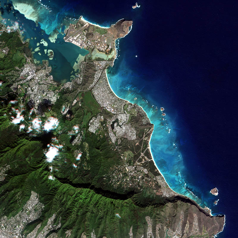
RapidEye (RESA) - Level 3A OrthoTile
The RapidEye Earth observation system comprised five satellites equipped with high-resolution optical sensors. Co-funded by the German Federal Government, the fleet of satellites was launched from the Baikonur cosmodrome in Kazakhstan in 2008. RapidEye is owned by Planet Labs, Inc. It has been operated by Planet Labs Germany GmbH until the constellation was retired in March 2020.
With all 5 satellites arranged in one orbit the RapidEye constellation was capable of taking images of the Earth's surface at high repeat rates with a maximum of 5 million km² per day. With a spatial resolution of 6.5m the 5-band sensors onboard the RapidEye satellites operated in the visible and near-infrared portions of the electromagnetic spectrum. For more information see: https://www.dlr.de/rd/en/desktopdefault.aspx/tabid-2440/3586_read-5336/
The PlanetScope data of this collection has been purchased by the German Space Agency with funds from the Ministry of Economy and is available for Germany-based researchers for scientific use. The data collection is maintained by the German Satellite Data Archive (D-SDA) of DLR’s Earth Observation Center and can be accessed via the EOWEB Geoportal.
The RapidEye Analytic Ortho Tile (L3A) product is orthorectified, multispectral data and is suitable for many data science and analytic applications that require imagery with an accurate geolocation and cartographic projection. It eliminates the perspective effect on the ground (not on buildings), restoring the geometry of a vertical shot. In addition to orthorectification, the imagery has radiometric corrections applied to correct for any sensor artifacts and transformation to at-sensor radiance.
For more details see:
https://assets.planet.com/docs/Planet_Combined_Imagery_Product_Specs_letter_screen.pdf
- Identification
- Distribution
- Quality
- Spatial rep.
- Ref. system
- Content
- Portrayal
- Metadata
- Md. constraints
- Md. maintenance
- Schema info
Identification
Data identification
Citation
- Date (Creation)
- 2014-09-01T12:00:00
- Citation identifier
- https://geoservice.dlr.de/catalogue/srv/metadata/d04a9e1a-0696-4442-9876-9a6dc6b40b58
- Presentation form
- Digital image
- Status
- Completed
- Maintenance and update frequency
- As needed
-
GEMET - INSPIRE themes, version 1.0
-
-
Orthoimagery
-
- Keywords
-
-
urn:eop:DLR:EOWEB:RapidEye.RESA.L3A
-
RapidEye
-
REIS
-
Optical
-
visible wavelengths
-
infrared wavelengths
-
- Use limitation
-
Nutzungseinschränkungen: Das DLR ist nicht haftbar für Schäden, die sich aus der Nutzung ergeben. / Use Limitations: DLR not liable for damage resulting from use.
Legal constraints
- Access constraints
- Other restrictions
Legal constraints
- Use constraints
- Other restrictions
- Other constraints
-
Nutzungsbedingungen / License: https://geoservice.dlr.de/resources/licenses/resa/RESA-License-Agreement-Planet-Data-en.pdf
- Spatial representation type
- Grid
- Denominator
- 10000
- Language
- English
- Character set
- UTF8
))
Distribution
Distribution
- Distribution format
-
-
GeoTIFF
()
-
GeoTIFF
()
Digital transfer options
- OnLine resource
-
Planet Labs, Inc.
(
WWW:LINK-1.0-http--link
)
For non-scientific users
- OnLine resource
-
Planet Labs Germany GmbH – RESA
(
WWW:LINK-1.0-http--link
)
For scientific users
- OnLine resource
- EOWEB Collection
Quality
Data quality
- Hierarchy level
- Series
Domain consistency
- Measure identification
- INSPIRE / Conformity_001
Conformance result
Citation
- Date (Publication)
- 2010-12-08
- Explanation
-
See the referenced specification
- Pass
- Yes
- Statement
-
L3A data: radiometric sensor corrected data. These data have been orthorectified using a DTED-level-1-SRTM (or better) elevation model.
For more details see:
https://assets.planet.com/docs/Planet_Combined_Imagery_Product_Specs_letter_screen.pdf
Spatial rep.
Grid spatial representation
- Number of dimensions
- 2
Dimension
- Dimension name
- Row
- Dimension size
- 1
- Resolution
- 5 m
Dimension
- Dimension name
- Column
- Dimension size
- 1
- Resolution
- 5 m
- Cell geometry
- Area
- Transformation parameter availability
- No
Ref. system
- Reference system identifier
- UTM/WGS84
Metadata
Metadata
- File identifier
- d04a9e1a-0696-4442-9876-9a6dc6b40b58 XML
- Metadata language
- English
- Character set
- UTF8
- Hierarchy level
- Series
- Hierarchy level name
-
Dataseries
- Date stamp
- 2024-06-27T14:46:29
- Metadata standard name
-
ISO 19115-1:2014/19139
Overviews

Spatial extent
Provided by
