 My GeoNetwork catalogue
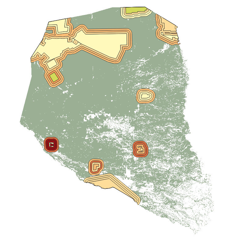
Geo-ForPy - Forest Cover per Protected Area in the Paraguayan Chaco - 2000-2020
This product is a vector file of the protected areas of the Paraguayan Chaco. It contains information on the forest cover within each protected area and a 5, 10, and 15 km buffer zone around these areas, for the years 2000 until 2020. Hence, this product aggregates the information of 21 annual forest maps of the Paraguayan Chaco to the level of protected areas and provides the basis for further analysis as conducted in the following publication: https://doi.org/10.3390/f130100 25
INSPIRE
Identification
- File identifier
- d1d97c73-eff4-411b-93d6-f4a30ea05faa XML
- Hierarchy level
- Dataset
Online resource
- Protocol
-
OGC:WMS
- Protocol
-
WWW:LINK-1.0-http--link
- Protocol
-
WWW:LINK-1.0-http--link
- Protocol
-
WWW:LINK-1.0-http--link
Resource identifier
- Metadata language
- English
- Spatial representation type
- Grid
Encoding
- Format
-
Geopackage
Projection
Classification of data and services
- Topic category
-
- Biota
Classification of data and services
Coupled resource
Coupled resource
Classification of data and services
Coupled resource
Coupled resource
Keywords
-
GEMET - INSPIRE themes, version 1.0
-
-
Land cover
-
Other keywords
- Keywords
-
-
opendata
-
DLR
-
EOC
-
GeoForPy
-
Forest
-
Forest Cover
-
Landsat-5
-
Landsat-7
-
Landsat-8
-
Paraguay
-
random forest
-
protected areas
-
Geographic coverage
))
Temporal reference
Temporal extent
- Begin
- 2000-01-01T00:00:00
- End
- 2020-12-31T23:59:59
Temporal extent
- Date (Creation)
- 2022-09-27T00:00:00
Quality and validity
- Lineage
-
This data set provides 21 years of forest cover losses in the protected areas and surrounding buffer zones in the Paraguayan Chaco. All information is given in square meter. The forest cover per protected area/buffer zone was derivated from the forest masks (2000 – 2020) which are a product of the Geo-ForPy project.
- Denominator
- 60000
Conformity
Conformity
Conformity
Conformity
Conformity
Conformity
- Explanation
-
See the referenced specification.
Restrictions on access and use
- Access constraints
- There are no limitations on public access to spatial data sets and services.
- Access constraints
-
Nutzungsbedingungen: Lizenz, https://creativecommons.org/licenses/by/4.0/ Terms of use: License, https://creativecommons.org/licenses/by/4.0/
- Access constraints
-
{"id": "cc-by-4.0",
"name": "Creative-Commons - Attribution 4.0 International (CC BY 4.0)",
"url": " http://dcat-ap.de/def/licenses/cc-by/4.0 ",
"quelle": "Copyright DLR (2022)"}
Responsible organization (s)
Contact for the resource
- Organisation name
-
German Aerospace Center (DLR)
- Organisation name
-
German Aerospace Center (DLR)
Responsible organization (s)
Contact for the resource
- Organisation name
-
German Aerospace Center (DLR)
- Organisation name
-
German Aerospace Center (DLR)
Metadata information
Contact for the metadata
- Organisation name
-
German Aerospace Center (DLR)
- Date stamp
- 2024-06-20T13:07:17
- Metadata language
- English
- Character set
- UTF8
SDS
Conformance class 1: invocable
Access Point URL
Endpoint URL
Technical specification
Conformance class 2: interoperable
Access constraints
Limitation
Use constraints
Limitation
Responsible custodian
Contact for the resource
Overviews
Spatial extent
Provided by
