 My GeoNetwork catalogue
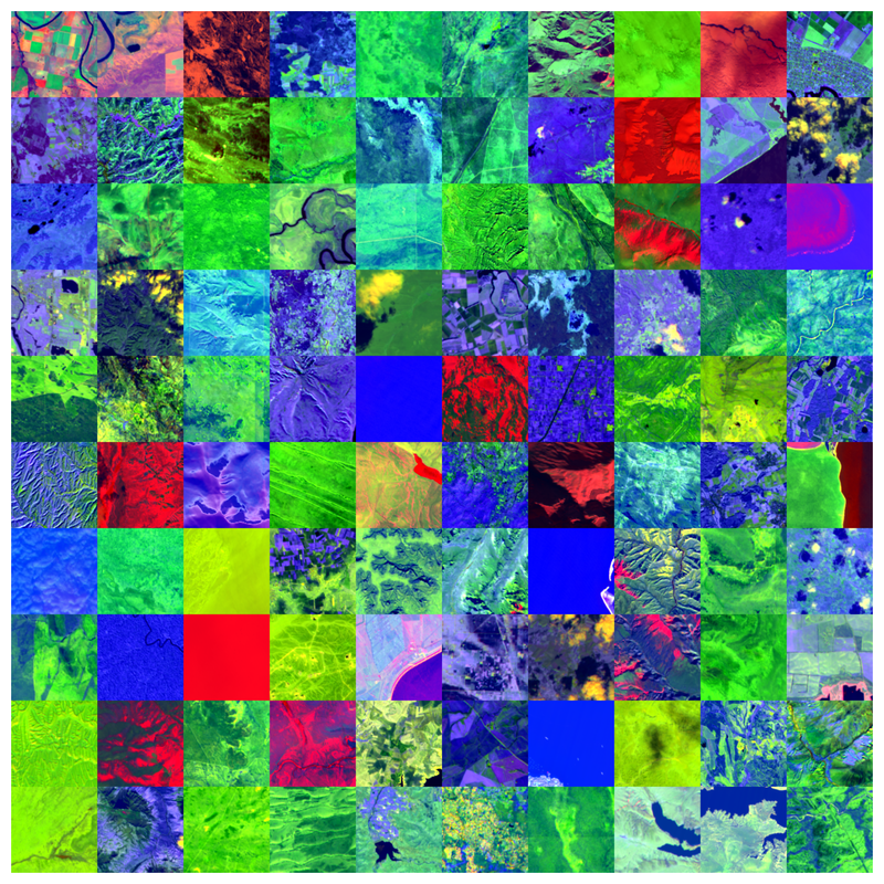
EnMAP HSI – SpectralEarth, non-georeferenced – Global
The Environmental Mapping and Analysis Program (EnMAP) is a German hyperspectral satellite mission to monitoring and characterise Earth’s environment on a global scale. EnMAP measures and models key dynamic processes of Earth’s ecosystems by extracting geochemical, biochemical and biophysical parameters that provide information on the status and evolution of various terrestrial and aquatic ecosystems. The mission’s main objective is to study and decipher coupled environmental processes and to assist and promote the sustainable management of Earth’s resources.
This collection includes Level 0 quicklook images of the mission. For more information, please see the mission website: https://www.enmap.org/mission/
Simple
- Date (Creation)
- 2024-08-15T00:00:00
- Citation identifier
- https://geoservice.dlr.de/catalogue/srv/metadata/d98099fd-b2c2-4749-9a05-d00ef0a0df49
- Presentation form
- Digital map
- Purpose
-
Geospatial Foundation Model training and evaluation.
- Status
- ongoing
- Maintenance and update frequency
- Daily
-
GEMET - INSPIRE themes, version 1.0
-
-
Orthoimagery
-
- Keywords
-
-
DLR
-
EOC
-
ENMAP
-
HSI
-
Global
-
hyperspectral
-
geospatial foundation models
-
land cover classification
-
unsupervised change detection
-
- Use limitation
-
Nutzungseinschränkungen: Das DLR ist nicht haftbar für Schäden, die sich aus der Nutzung ergeben. / Use Limitations: DLR not liable for damage resulting from use.
- Access constraints
- Other restrictions
- Other constraints
- Öffentlicher Zugriff beschränkt entsprechend Artikel 13(1)(e) der INSPIRE-Richtlinie: e) aufgrund nachteiliger Auswirkungen auf die Rechte des geistigen Eigentums
- Use constraints
- Other restrictions
- Other constraints
-
Nutzungsbedingungen: Lizenz, https://www.enmap.org/data_access/ Terms of use: https://www.enmap.org/data_access/
- Spatial representation type
- Grid
- Denominator
- 60000
- Language
- English
- Character set
- UTF8
- Topic category
-
- Imagery base maps earth cover
))
- Begin date
- 2022-05-01T00:00:00
- End date
- 2024-05-01T00:00:00
- Unique resource identifier
- EPSG:4326
- Distribution format
-
-
GeoTIFF
()
-
GeoTIFF
()
- OnLine resource
- EOC Download Service ( WWW:LINK-1.0-http--link )
- Hierarchy level
- Series
Domain consistency
- Measure identification
- INSPIRE / Conformity_001
Conformance result
- Date (Publication)
- 2010-12-08
- Explanation
-
See the referenced specification.
- Pass
- Yes
- Statement
-
SpectralEarth is derived from DLR EnMAP L2A data. Downstream task data have been collected from CORINE landcover, CDL, and NLCD.
- Description
-
Processing: Spectral Earth data have been filtered for clouds, other atmospheric artifacts, and the EnMAP tiles have been patchified into 128x128 spatial pixels. For a subset of 73k of the data there exists time series of up to about 20 with the majority of patches having two timestamps.
Quality Assurance: The data quality aligns with EnMAP L2A data product quality.
- File identifier
- d98099fd-b2c2-4749-9a05-d00ef0a0df49 XML
- Metadata language
- English
- Character set
- UTF8
- Hierarchy level
- Series
- Hierarchy level name
-
Dataseries
- Date stamp
- 2024-09-17T09:14:28
- Metadata standard name
-
ISO 19115-1:2014/19139
- Metadata standard version
-
2003/Cor.1:2006
Overviews

Spatial extent
Provided by
