 My GeoNetwork catalogue
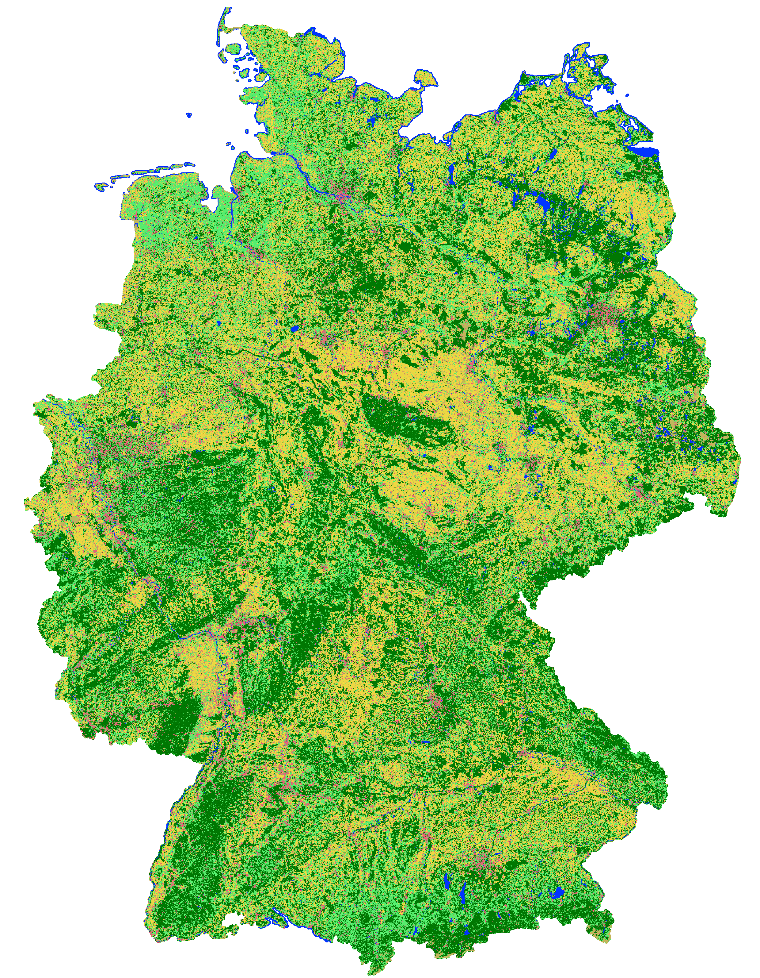
Landcover classification map of Germany 2016 based on Sentinel-2 data
This landcover map was produced as an intermediate result in the course of the project incora (Inwertsetzung von Copernicus-Daten für die Raumbeobachtung, mFUND Förderkennzeichen: 19F2079C) in cooperation with ILS (Institut für Landes- und Stadtentwicklungsforschung gGmbH) and BBSR (Bundesinstitut für Bau-, Stadt- und Raumforschung) funded by BMVI (Federal Ministry of Transport and Digital Infrastructure). The goal of incora is an analysis of settlement and infrastructure dynamics in Germany based on Copernicus Sentinel data.
This classification is based on a time-series of monthly averaged, atmospherically corrected Sentinel-2 tiles (MAJA L3A-WASP: https://geoservice.dlr.de/web/maps/sentinel2:l3a:wasp ; DLR (2019): Sentinel-2 MSI - Level 2A (MAJA-Tiles)- Germany). It consists of the following landcover classes:
10: forest
20: low vegetation
30: water
40: built-up
50: bare soil
60: agriculture
Potential training and validation areas were automatically extracted using spectral indices and their temporal variability from the Sentinel-2 data itself as well as the following auxiliary datasets:
- OpenStreetMap (Map data copyrighted OpenStreetMap contributors and available from htttps://www.openstreetmap.org)
- Copernicus HRL Imperviousness Status Map 2018 (© European Union, Copernicus Land Monitoring Service 2018, European Environment Agency (EEA))
- S2GLC Land Cover Map of Europe 2017 (Malinowski et al. 2020: Automated Production of Land Cover/Use Map of Europe Based on Sentinel-2 Imagery. Remote Sens. 2020, 12(21), 3523; https://doi.org/10.3390/rs 12213523)
- Germany NUTS administrative areas 1:250000 (© GeoBasis-DE / BKG 2020 / dl-de/by-2-0 / https://gdz.bkg.bund.de/index.php/default/nuts-gebiete-1-250-000-stand-31-12-nuts250-31-12.html )
- Contains modified Copernicus Sentinel data (2016), processed by mundialis
Processing was performed for blocks of federal states and individual maps were mosaicked afterwards.
For each class 100,000 pixels from the potential training areas were extracted as training data.
An exemplary validation of the classification results was perfomed for the federal state of North Rhine-Westphalia as its open data policy allows for direct access to official data to be used as reference. Rules to convert relevant ATKIS Basis-DLM object classes to the incora nomenclature were defined. Subsequently, 5.000 reference points were randomly sampled and their classification in each case visually examined and, if necessary, revised to obtain a robust reference data set. The comparison of this reference data set with the incora classification yielded the following results:
overall accuracy: 88.4%
class: user's accuracy / producer's accuracy (number of reference points n)
forest: 96.7% / 94.3% (1410)
low vegetation: 70.6% / 84.0% (844)
water: 98.5% / 94.2% (69)
built-up: 98.2% / 89.8% (983)
bare soil: 19.7% / 58.5% (41)
agriculture: 91.7% / 85.3% (1653)
Incora report with details on methods and results: pending
INSPIRE
Identification
- File identifier
- db130a09-fc2e-421d-95e2-1575e7c4b45c XML
- Hierarchy level
- Dataset
Online resource
- Protocol
-
WWW:DOWNLOAD-1.0-http--download
- Protocol
-
WWW:DOWNLOAD-1.0-http--download
Resource identifier
- code
-
dataset
- Metadata language
- English
- Spatial representation type
- Grid
Encoding
- Format
-
GeoTIFF
- Version
-
1.0
Projection
- code
-
EPSG:32632 (UTM 32N)
Classification of data and services
- Topic category
-
- Geoscientific information
Classification of data and services
Coupled resource
Coupled resource
Classification of data and services
Coupled resource
Coupled resource
Keywords
-
GEMET - INSPIRE themes, version 1.0
-
-
Land cover
-
Land use
-
Other keywords
- Theme
-
-
Sentinel-2
-
Classification
-
Land Cover
-
mFUND
-
MAJA
-
Infrastuktur
-
Umwelt
-
Regionen und Städte
-
mfund-projekt:incora
-
mfund-fkz:19F2079C
-
incora
-
- Place
-
-
Germany
-
Geographic coverage
))
Temporal reference
Temporal extent
- Begin
- 2016-01-01
- End
- 2016-12-31
Temporal extent
- Date (Publication)
- 2020-12-01
Quality and validity
- Lineage
-
derived from Sentinel-2 MSI - Level 3A-WASP
- Distance
- 10 meters
Conformity
Conformity
Conformity
Conformity
Conformity
Conformity
- Explanation
-
See specified reference
Restrictions on access and use
- Access constraints
- no limitations to public access
- Access constraints
-
Data licence Germany - attribution - version 2.0 or later (DL-DE->BY-2.0) | Datenlizenz Deutschland - Namensnennung - Version 2.0 oder neuer
- Access constraints
-
{ "id": "dl-by-de/2.0", "name": "Datenlizenz Deutschland Namensnennung 2.0", "url": " https://www.govdata.de/dl-de/by-2-0 ", "quelle": "Source: mundialis GmbH & Co. KG" }
Responsible organization (s)
Contact for the resource
- Organisation name
-
mundialis GmbH & Co. KG
Responsible organization (s)
Contact for the resource
- Organisation name
-
mundialis GmbH & Co. KG
Metadata information
Contact for the metadata
- Organisation name
-
mundialis GmbH & Co. KG
- Date stamp
- 2023-02-28T10:32:47
- Metadata language
- English
- Character set
- UTF8
SDS
Conformance class 1: invocable
Access Point URL
Endpoint URL
Technical specification
Conformance class 2: interoperable
Access constraints
Limitation
Use constraints
Limitation
Responsible custodian
Contact for the resource
Overviews
Spatial extent
Provided by
