 My GeoNetwork catalogue
Geo-ForPy - Forest Cover Changes in the Paraguayan Chaco - Landsat-5/7/8,1987-2020
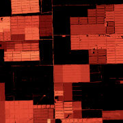
The dataset is based on the analysis of forest cover dynamics in the Paraguayan Chaco (northeastern part of Paraguay) between 1987 and 2020. The underlying forest masks were derived through annual forst classifications with a Random-Forest-Classifier trained on Landsat data from 1987 until 2020. The map shows the year in which the forest area was lost.
Simple
- Date (Creation)
- 2022-09-01T00:00:00
- Citation identifier
- https://geoservice.dlr.de/catalogue/srv/metadata/dbc3ec56-a9d7-4050-ad14-1ff2e72a753
- Presentation form
- Digital map
- Purpose
-
This data set provides an overview over the dynamic development of the forest cover in the Paraguayan Chaco between 1987 and 2020.
- Status
- Completed
- Maintenance and update frequency
- As needed
-
GEMET - INSPIRE themes, version 1.0
-
-
Land cover
-
- Keywords
-
-
opendata
-
DLR
-
EOC
-
GeoForPy
-
Forest
-
Forest Cover
-
Landsat-5
-
Landsat-7
-
Landsat-8
-
Paraguay
-
Time Series
-
- Use limitation
-
Nutzungseinschränkungen: Das DLR ist nicht haftbar für Schäden, die sich aus der Nutzung ergeben. / Use Limitations: DLR not liable for damage resulting from use.
- Access constraints
- Other restrictions
- Use constraints
- Other restrictions
- Other constraints
-
Nutzungsbedingungen: Lizenz, https://creativecommons.org/licenses/by/4.0/ Terms of use: License, https://creativecommons.org/licenses/by/4.0/
- Other constraints
-
{"id": "cc-by-4.0",
"name": "Creative-Commons - Attribution 4.0 International (CC BY 4.0)",
"url": " http://dcat-ap.de/def/licenses/cc-by/4.0 ",
"quelle": "Copyright DLR (2022)"}
- Spatial representation type
- Grid
- Denominator
- 60000
- Language
- English
- Character set
- UTF8
- Topic category
-
- Biota
))
- Begin date
- 1987-01-01T00:00:00
- End date
- 2020-12-31T23:59:59
- Unique resource identifier
- EPSG:32721 - WGS 84 / UTM zone 21S
- Number of dimensions
- 2
- Dimension name
- Column
- Dimension size
- 18909
- Resolution
- 30 m
- Dimension name
- Row
- Dimension size
- 22341
- Resolution
- 30 m
- Cell geometry
- Area
- Transformation parameter availability
- No
- Distribution format
-
-
Cloud Optimized GeoTIFF
()
-
Cloud Optimized GeoTIFF
()
- OnLine resource
-
FOREST_COVER_PRY_1986_2020_P1Y
(
OGC:WMS
)
WMS Access: Forest Cover Changes in the Paraguayan Chaco 1987-2020
- OnLine resource
- HTTP download Geo-ForPy - Paraguayan Chaco, 1987-2020 ( WWW:LINK-1.0-http--link )
- OnLine resource
-
Geo-ForPy - Deforestration in Latin America and the Paraguayan Chaco
(
WWW:LINK-1.0-http--link
)
Geo-ForPy - project Webpage
- OnLine resource
-
Understanding 34 Years of Forest Cover Dynamics across the Paraguayan Chaco: Characterizing Annual Changes and Forest Fragmentation Levels between 1987 and 2020
(
WWW:LINK-1.0-http--link
)
Article
- Hierarchy level
- Dataset
Domain consistency
- Measure identification
- INSPIRE / Conformity_001
Conformance result
- Date (Publication)
- 2010-12-08
- Explanation
-
See the referenced specification.
- Pass
- Yes
- Statement
-
This data set provides an overview of 34 years of forest cover losses in the Paraguayan Chaco. The year in which there was the last change of an area from forest to non-forest is represented by its colour. Afforestaton cannot be represented in this dataset.
- Description
-
Geo-ForPy - Forest cover changes in the Paraguayan Chaco 1987-2020 - Processing
Data:
The used forest masks (1987 – 2020) are a product oft he GeoFor-Py project. More information on this data set can be found under the following link.
Processing:
For this overview, the forest masks from 1986 to 2020 were compared with each other. The year in which a pixel changed its value from forest to non-forest was stored in this data set. If there were several changes between forest and non-forest, the last change was saved.
Quality Assurance:
The underlying forest masks have overall accuracies between 85% and 97%. Missclassifications directly affect the derived year of deforestation and can cause salt and pepper effects within continuously deforested areas.
- File identifier
- dbc3ec56-a9d7-4050-ad14-1ff2e72a753 XML
- Metadata language
- English
- Character set
- UTF8
- Hierarchy level
- Dataset
- Hierarchy level name
-
Dataset
- Date stamp
- 2024-06-20T13:07:37
- Metadata standard name
-
ISO 19115-1:2014/19139
Overviews

Spatial extent
Provided by
