 My GeoNetwork catalogue
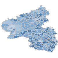
Abwasser - Öffentliche Abwasserentsorgung 2013 - Abwasserkanalnetz insgesamt 2013, in Kilometer (Verbandsgemeindeebene)
Thematische Karte zur Abwasserentsorgung in den Kreisen, den Verbandsgemeinden und den Gemeinden. Nachgewiesen wird die Abwasserbeseitigung nach Art des Kanals. Die Länge des Kanalnetzes insgesamt in Kilometer, sowie je angeschlossenem Einwohner in Meter. Außerdem wird das Kanalnetz zur Schmutzwasserentsorgung insgesamt in Kilometer und anteilig in Prozent für Misch- und Trennkanalisation dargestellt.:Abwasserkanalnetz insgesamt 2013, in Kilometer, Verbandsgemeineebene
Simple
Identification info
- Date (Revision)
- 2024-06-30
-
mapbender.2.registryId
-
-
2f23ed6e-0186-4c2b-8380-748389036509
-
- Keywords
-
-
Umwelt
-
Abwasser
-
Abwasserentsorgung
-
Kanalnetz
-
Schmutzwasserentsorgung
-
Mischkanalisation
-
Trennkanalisation
-
Verbandsgemeindedaten
-
infoMapAccessService
-
- Access constraints
- Other restrictions
- Other constraints
- Es gelten keine Zugriffsbeschränkungen
- Use constraints
- Other restrictions
- Other constraints
-
Lizenz: cc-by-3.0 - Creative Commons: Namensnennung 3.0 Deutschland - http://creativecommons.org/licenses/by/3.0/de/ - Quellenvermerk: Source note required by license, but not given!
- Other constraints
-
{"id":"cc-by-3.0","name":"Creative Commons: Namensnennung 3.0 Deutschland","url":"http:\/\/creativecommons.org\/licenses\/by\/3.0\/de\/","quelle":"Source note required by license, but not given!"}
- Service Type
- view
- Service Version
-
OGC:WMS 1.1.1
))
- Coupling Type
- Loose
Contains Operations
- Operation Name
-
GetCapabilities
- Distributed Computing Platforms
- Web services
- Distribution format
-
- OnLine resource
-
UMW3L1VG
(
OGC:WMS-1.1.1-http-get-map
)
Abwasserkanalnetz insgesamt 2013, in Kilometer, Verbandsgemeineebene
- Hierarchy level
- Service
- Other
-
Dienst
Conformance result
- Date (Publication)
- 2010-12-08
- Explanation
-
No explanation available
- Pass
- Yes
Conformance result
- Date (Publication)
- 2009-10-20
- Explanation
-
No explanation available
- Pass
- Yes
Conformance result
- Date (Publication)
- 2014-12-11
- Explanation
-
No explanation available
- Pass
- Yes
Conformance result
- Date (Publication)
- 2008-12-04
- Explanation
-
No explanation available
- Pass
- Yes
Conformance result
- Date (Publication)
- 2014-12-11
- Explanation
-
No explanation available
- Pass
- Yes
Conformance result
- Date (Publication)
- 2013-12-10
- Explanation
-
No explanation available
- Pass
- Yes
Conformance result
- Date (Publication)
- 2011-02-05
- Explanation
-
No explanation available
- Pass
- Yes
Conformance result
- Date (Publication)
- 2010-12-08
- Explanation
-
No explanation available
- Pass
- Yes
- File identifier
- dea95f56-90f3-fb2a-f773-6e41d468f16f XML
- Metadata language
- Deutsch
- Character set
- UTF8
- Hierarchy level
- Service
- Hierarchy level name
-
Darstellungsdienst
- Date stamp
- 2026-04-26
- Metadata standard name
-
ISO19119
- Metadata standard version
-
2005/PDAM 1
Overviews
Spatial extent
Provided by
