 My GeoNetwork catalogue
Processed seismic data of Cruise SO104 CINCA 1995
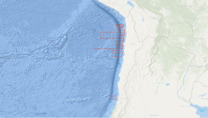
The CINCA marine geoscience investigations on the convergent continental margin of Chile between 19°S and 33°30'S were accomplished during three legs of RV SONNE cruise SO-104, from 22. July to 15. October 1995. The objectives of the first leg are to contribute to an understanding of the geological architecture and of the tectonic mechanism in the area of the Chile convergent zone through a geophysical assessment of the tectonic structures of the Chile continental margin and the adjacent oceanic Nazca plate. During the first leg from 22. July to 24. August 1995 multichannel seismic reflection data with BGR's new digital streamer were collected along a systematic grid with a total traverse length of 4,494 km simultaneously with the acquisition of magnetic, gravimetric, Hydrosweep and Parasound data over a total traverse length of 7,012 km. GFZ's mobile land array of 12 seismic stations recorded the air gun shots fired by RV SONNE within the CINCA area. Three seismic lines were surveyed between 32°30'S and 33°30'S in the area of the CONDOR project. Here, the surface of the downbending oceanic crust is smooth. The 5,000 m to 6,000 m deep trench floor is underlain by sediments, in excess 2,500 m thick. The inner trench slope consists of a landward thickening accretionary wedge which terminates against a body forming the base of a fore arc basin near Valparaiso. The principal area of the CINCA project extends between 19°S and 26°S and comprises the convergent continental margin, the Peru-Chile trench and the seaward adjacent part of the Nazca plate up to approximately 75°W longitude. The tectonic regime of these units of the CINCA area is very different from the tectonic system of the respective units of the CONDOR area. The Eocene-aged and sediment-starved oceanic crust of the Nazca plate becomes blockfaulted when approaching the outer trench slope break. The 50 km to 70 km wide outer trench slope is characterized by a complex system of horst and graben structures in the CINCA area probably resulting from the strong downbending. Steep fault scarps forming the flanks of the horsts reach vertical offsets varying between few hundreds of metres to 1,000 m, and locally even more. The 7,000 m to 8,l00 m deep trench is very narrow and mostly sediment-starved in the CINCA area. Morphology and architecture of the continental margin of the CINCA area are controlled by planar and listric faulting and tilted blocks of inferred continental nature, which apparently slid down into the trench. The inferred continental blocks, overlying a reflective mass, are covered by sediments of presumably turbiditic nature. An accretionary wedge is difficult to define on the seismic single channel records from the CINCA area. However, processed seismic data show a deep reflective mass underlying the downfaulted blocks of inferred continental nature. This deep reflective mass is interpreted to consist of a tectonically eroded and underplated continental crust-basalt melange forming the transition between the downfaulted continental upper plate and the subducting oceanic lower plate. Complex structural highs of still unknown origin and nature have been observed on the upper continental slope at 20°S, 24°S and 25°S. The northernmost structural high represents the seaward termination of the Iquique fore arc basin. The accuracy of the acquired gravity and bathymetric data is very good, i.e. better than 1 mGal and less than 10 m. The Chile trench is associated with strong negative gravity anomalies, and the continental margin is characterized by several positive and negative gravity anomalies of varying size and amount. The first results of magnetic modeling show, that the intensive blockfaulting of the oceanic crust across the outer trench slope causes no loss of the magnetization of the oceanic crust. The air gun shots fired by RV SONNE in 50 m intervals along 17 seismic traverses were recorded by GFZ's mobile land array in the coastal area of Chile. Good quality data were obtained out to about 100 km distance and in some cases even out to about 150 km.
INSPIRE
Identification
- File identifier
- e40152d2-d11c-402a-bf84-81d2f3225205 XML
- Hierarchy level
- Dataset
Online resource
Resource identifier
- code
-
eed9b6f2-ac36-feb3-a42d-081fd7a8335e
- Metadata language
- English
- Spatial representation type
- Vector
Encoding
- Format
-
Shapefile
- Version
-
n/a
Projection
- code
- EPSG:4326
Classification of data and services
- Topic category
-
- Geoscientific information
Classification of data and services
Coupled resource
Coupled resource
Classification of data and services
Coupled resource
Coupled resource
Keywords
-
GEMET - INSPIRE themes, version 1.0
-
-
Geologie
-
geology
-
-
GEMET - Concepts, version 2.4
-
-
geophysics
-
Geophysik
-
raw material
-
Rohstoff
-
Other keywords
- Theme
-
-
Marine geology
-
Meeresgeologie
-
Seismics
-
Seismik
-
Two-dimensional seismic reflection
-
zweidimensionale Reflektionsseismik
-
- Place
-
-
Southeast Pacific Ocean
-
Südost-Pazifik
-
Chile
-
Geographic coverage
))
Temporal reference
Temporal extent
Temporal extent
- Date (Creation)
- 1995-08-24
Quality and validity
- Lineage
-
SO104-02, SO104-03, SO104-06, SO104-10, SO104-13, SO104-15, SO104-19, SO104-23, SO104-24, SO104-24A, SO104-25, SO104-28 and SO104-29 consist of raw data. Lines SO104-05, SO104-07, SO104-08, SO104-09, SO104-11, SO104-12, SO104-16, SO104-17, SO104-18 and SO104-20 consist of stacked data. Lines SO104-22, SO104-026 and SO104-27 are migrated data.
Conformity
Conformity
Conformity
Conformity
Conformity
Conformity
- Explanation
-
siehe dazu die angegebene Durchführungsbestimmung
Restrictions on access and use
- Access constraints
- Es gelten keine Zugriffsbeschränkungen
- Access constraints
-
Allgemeine Geschäftsbedingungen, siehe http://www.bgr.bund.de/AGB - General terms and conditions, see http://www.bgr.bund.de/AGB_en . Die bereitgestellten Informationen sind bei Weiterverwendung wie folgt zu zitieren: Datenquelle: SO104 CINCA 1995, (c) BGR, Hannover, 2018
Responsible organization (s)
Contact for the resource
- Organisation name
-
Federal Institute for Geosciences and Natural Resources
Responsible organization (s)
Contact for the resource
- Organisation name
-
Federal Institute for Geosciences and Natural Resources
Metadata information
Contact for the metadata
- Organisation name
-
Bundesanstalt für Geowissenschaften und Rohstoffe (BGR)
- Date stamp
- 2023-11-16
- Metadata language
- English
- Character set
- UTF8
SDS
Conformance class 1: invocable
Access Point URL
Endpoint URL
Technical specification
Conformance class 2: interoperable
Access constraints
Limitation
Use constraints
Limitation
Responsible custodian
Contact for the resource
Overviews
Spatial extent
Provided by
