 My GeoNetwork catalogue
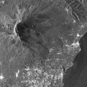
TerraSAR-X - CEOS Geohazard Supersites
This collection contains TerraSAR-X Level 1b data acquired over the pre-defined Geohazard Supersites and a number of CEOS projects regions. The collection comprises mainly complex (SSC) with a number of detected (MGD) products. TerraSAR-X data can be ordered by a Principal Investigator (PI) of a respective Supersite region under the terms of a TerraSAR-X Science proposal accepted by DLR. Data is available for download by the Geohazard scientific community under the terms of the user license.
Supersites are single sites or extended areas of high priority to the Geohazards community in which active single or multiple geological hazards pose a threat to human population and/or critical facilities. The Supersites initiative provides access to spaceborne and in-situ geophysical data of selected sites prone to earthquake, volcano or other hazards.
For further information see: http://ceos.org/ourwork/workinggroups/disasters/gsnl/
Overview of permament Supersites: http://geo-gsnl.org/supersites/permanent-supersites/
INSPIRE
Identification
- File identifier
- e514d88d-35de-4d96-8931-db442f2404a7 XML
- Hierarchy level
- Series
Online resource
- Protocol
-
WWW:LINK-1.0-http--link
- Protocol
-
WWW:LINK-1.0-http--link
- Protocol
-
WWW:LINK-1.0-http--link
- Protocol
-
WWW:LINK-1.0-http--link
- Protocol
-
WWW:LINK-1.0-http--link
Resource identifier
- Metadata language
- English
- Spatial representation type
- Grid
Encoding
Projection
- code
-
UTM/UPS
Classification of data and services
- Topic category
-
- Imagery base maps earth cover
Classification of data and services
Coupled resource
Coupled resource
Classification of data and services
Coupled resource
Coupled resource
Keywords
- GEMET - INSPIRE themes, version 1.0
-
-
Orthoimagery
-
Natural risk zones
-
Other keywords
- Keywords
-
-
TerraSAR-X
-
TSX
-
SAR
-
natural disasters
-
CEOS
-
Geohazard
-
Supersites
-
Geographic coverage
))
Temporal reference
Temporal extent
- Begin
- 2008-05-02T00:00:00
Temporal extent
- Date (Creation)
- 2019-02-01T00:00:00
Quality and validity
- Lineage
-
Input data sets:
- Orbit products
- Attitude products
- Extracted house-keeping parameters
- Denominator
- 6000
Conformity
Conformity
Conformity
Conformity
Conformity
Conformity
- Explanation
-
See the referenced specification.
Restrictions on access and use
- Access constraints
-
Zufriffsbeschränkt, Registrierung erforderlich / restricted access, registration required
- Access constraints
-
Nutzungsbedingungen: Lizenz / Terms of use: License, https://geoservice.dlr.de/resources/licenses/supersites/TSX-TDX_GEO-Supersite_UserLicense.pdf
Responsible organization (s)
Contact for the resource
- Organisation name
-
German Aerospace Center (DLR)
- Organisation name
-
German Aerospace Center (DLR)
Responsible organization (s)
Contact for the resource
- Organisation name
-
German Aerospace Center (DLR)
- Organisation name
-
German Aerospace Center (DLR)
Metadata information
Contact for the metadata
- Organisation name
-
German Aerospace Center (DLR)
- Date stamp
- 2024-06-20T13:06:59
- Metadata language
- English
- Character set
- UTF8
SDS
Conformance class 1: invocable
Access Point URL
Endpoint URL
Technical specification
Conformance class 2: interoperable
Access constraints
Limitation
Use constraints
Limitation
Responsible custodian
Contact for the resource
Overviews

Spatial extent
Provided by
