 My GeoNetwork catalogue
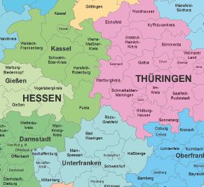
Verwaltungskarte Deutschland 1:2 500 000 - Länder
Die Verwaltungskarte Deutschland (Länder) ist eine Übersichtskarte der Länder der Bundesrepublik Deutschland im Maßstab 1:2500000. Sie ist als PDF-Datei, optimiert für das Druckformat DIN A3, verfügbar.
- Identification
- Distribution
- Quality
- Spatial rep.
- Ref. system
- Content
- Portrayal
- Metadata
- Md. constraints
- Md. maintenance
- Schema info
Identification
Data identification
Citation
- Alternate title
-
VK2500-L
- Date (Creation)
- 2012-01-01T00:00:00.000+01:00
- Date (Revision)
- 2024-12-31T00:00:00.000+01:00
- Citation identifier
- https://registry.gdi-de.org/id/de.bund.bkg.csw/face07e8-d890-4a8e-bf91-45b89f22378a
- Status
- On going
+49 69 6333-251
https://www.bkg.bund.de
Maintenance information
- Maintenance and update frequency
- Annually
- Update scope
- Dataset
- Maintenance note
-
Zwischenstände bei gegebenem Anlass, z.B. Gebietsreform
- Keywords
-
-
Verwaltungseinheiten
-
Verwaltungseinheit
-
Verwaltungsgrenzen
-
Statistische Einheiten
-
opendata
-
-
GEMET - Concepts, version 3.1
Legal constraints
- Use constraints
- Other restrictions
- Other constraints
-
Quellenvermerk: © GeoBasis-DE / BKG (Jahr des letzten Datenbezugs) dl-de/by-2-0
- Other constraints
-
{"id":"dl-by-de/2.0","name":"Datenlizenz Deutschland Namensnennung 2.0","url":" https://www.govdata.de/dl-de/by-2-0","quelle":"© GeoBasis-DE / BKG (Jahr des letzten Datenbezugs) dl-de/by-2-0\n https://sgx.geodatenzentrum.de/web_public/gdz/lizenz/deu/datenlizenz_deutschland_ergaenzungstext_namensnennung.pdf"}
Legal constraints
- Access constraints
- Other restrictions
- Other constraints
- Es gelten keine Zugriffsbeschränkungen
- Denominator
- 2500000
- Language
- Deutsch
- Character set
- UTF8
- Topic category
-
- Boundaries
Extent
Geographic description
- Extent type code
- Yes
- Geographic identifier
- Raumbezug des Datensatzes
))
- Code
- 000000000000
Distribution
Distribution
- Distribution format
-
-
PDF
(
1.4
)
-
PDF
(
1.4
)
Distributor
+49 69 6333-251
https://www.bkg.bund.de
- OnLine resource
- Produktseite des Geodatenzentrums
- OnLine resource
- Datendownload, PDF
- OnLine resource
- Dokumentation
- OnLine resource
- Nutzungsbedingungen
Quality
Data quality
- Hierarchy level
- Dataset
- Statement
-
Ableitung aus dem Datenbestand der Verwaltungsgebiete 1 : 2 500 000
Ref. system
- Unique resource identifier
- EPSG 5243: ETRS89 / LCC Deutschland (E-N)
Metadata
Metadata
- File identifier
- e656c6ad-c7c8-45f0-a829-1b14c9f2a19a XML
- Metadata language
- Deutsch
- Character set
- UTF8
- Hierarchy level
- Dataset
- Date stamp
- 2026-05-05
- Metadata standard name
-
ISO19115
- Metadata standard version
-
2003/Cor.1:2006
Overviews
Spatial extent
Provided by
